Property Record
4505 Fm 439, Belton, TX 76513


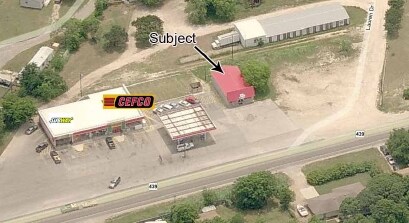
Property Detail
4505 Fm 439
107351
A0166BC C CRUISE, 13, ACRES 2.711
Commercialnec
Bell
B and X Area of moderate flood hazard, usually the area between the limits of the 100-year and 500-year floods.
Texas
2025
2.71 AC
2025
Outlying Bell County
021701
Killeen/Temple/Fort Hood
7,751 SF
Killeen-Temple, TX
NEARBY LISTINGS FOR SALE OR LEASE
-
-
View all Belton listings for sale on LoopNet.com
DEMOGRAPHICS near 4505 Fm 439
1 mile
3 mile
5 mile
2025 Total Population
2,161
12,616
49,602
2030 Population
2,329
13,493
52,903
Pop Growth 2025-2030
+ 7.77%
+ 6.95%
+ 6.65%
Average Age
41
40
37
2025 Total Households
780
4,660
17,211
HH Growth 2025-2030
+ 7.82%
+ 7.04%
+ 6.86%
Median Household Inc
$120,678
$115,665
$93,842
Avg Household Size
2.70
2.60
2.70
2025 Avg HH Vehicles
2.00
2.00
2.00
Median Home Value
$376,438
$389,533
$322,787
Median Year Built
2004
2005
2004
Nearby Places
Map Layers
Map Styles
 Street
 Aerial
Transit
 Traffic
 Biking
Places
Listings with unknown addresses are not visible on the map
- Restaurants
- Banks
- Shops
- Fitness
- Groceries
PUBLIC TRANSPORTATION
AIRPORT
Killeen Municipal
Drive
Walk
Distance
Killeen Municipal
19 min
13.5 mi
Robert Gray AAF
Drive
Walk
Distance
Robert Gray AAF
39 min
27.4 mi
Freight Ports
Port of Houston
Drive
Walk
Distance
Port of Houston
244 min
189.6 mi
Nearby Properties
Address
Land Use
TOTAL SIZE
Lot Size
Zoning
Address
Land Use
TOTAL SIZE
Lot Size
Zoning
230,571 SF
76.15 AC
Address
Land Use
TOTAL SIZE
Lot Size
Zoning
220,039 SF
13.10 AC
Address
Land Use
TOTAL SIZE
Lot Size
Zoning
143,630 SF
6.40 AC
Address
Land Use
TOTAL SIZE
Lot Size
Zoning
131,090 SF
8.87 AC
Address
Land Use
TOTAL SIZE
Lot Size
Zoning
127,080 SF
12.82 AC
Address
Land Use
TOTAL SIZE
Lot Size
Zoning
138,476 SF
8.23 AC
Address
Land Use
TOTAL SIZE
Lot Size
Zoning
189,833 SF
24.69 AC
Address
Land Use
TOTAL SIZE
Lot Size
Zoning
89,187 SF
10.23 AC
Address
Land Use
TOTAL SIZE
Lot Size
Zoning
82,750 SF
4.52 AC
Address
Land Use
TOTAL SIZE
Lot Size
Zoning
72,616 SF
4.19 AC
Address
Land Use
TOTAL SIZE
Lot Size
Zoning
49,855 SF
4.80 AC
Address
Land Use
TOTAL SIZE
Lot Size
Zoning
67,719 SF
5.61 AC
Address
Land Use
TOTAL SIZE
Lot Size
Zoning
35,315 SF
6.38 AC
Address
Land Use
TOTAL SIZE
Lot Size
Zoning
110,069 SF
11.12 AC
Address
Land Use
TOTAL SIZE
Lot Size
Zoning
46,429 SF
11.47 AC
Address
Land Use
TOTAL SIZE
Lot Size
Zoning
38,045 SF
71.04 AC
Address
Land Use
TOTAL SIZE
Lot Size
Zoning
17,400 SF
2.07 AC
Address
Land Use
TOTAL SIZE
Lot Size
Zoning
21,235 SF
2.12 AC
Address
Land Use
TOTAL SIZE
Lot Size
Zoning
Address
Land Use
TOTAL SIZE
Lot Size
Zoning
Address
Land Use
TOTAL SIZE
Lot Size
Zoning
21,424 SF
3.76 AC
Address
Land Use
TOTAL SIZE
Lot Size
Zoning
10,640 SF
0.95 AC
Address
Land Use
TOTAL SIZE
Lot Size
Zoning
4,987 SF
17.34 AC
Address
Land Use
TOTAL SIZE
Lot Size
Zoning
196,875 SF
Address
Land Use
TOTAL SIZE
Lot Size
Zoning
1 SF
18.23 AC
Address
Land Use
TOTAL SIZE
Lot Size
Zoning
27,880 SF
3.47 AC
Address
Land Use
TOTAL SIZE
Lot Size
Zoning
10,452 SF
1.23 AC
Address
Land Use
TOTAL SIZE
Lot Size
Zoning
15,616 SF
1.54 AC
Address
Land Use
TOTAL SIZE
Lot Size
Zoning
12,000 SF
5 AC
Address
Land Use
TOTAL SIZE
Lot Size
Zoning
28,061 SF
5.37 AC
The World's #1 Commercial Real Estate Marketplace
Connect with us
© 2026 CoStar Group
The information above has been obtained from sources believed reliable. While we do not doubt its accuracy we have not verified it and make no guarantee, warranty or representation about it. It is your responsibility to independently confirm its accuracy and completeness. Any projections, opinions, assumptions, or estimates used are for example only and do not represent the current or future performance of the property. The value of this transaction to you depends on tax and other factors which should be evaluated by your tax, financial, and legal advisors. You and your advisors should conduct a careful, independent investigation of the property to determine to your satisfaction the suitability of the property for your needs.