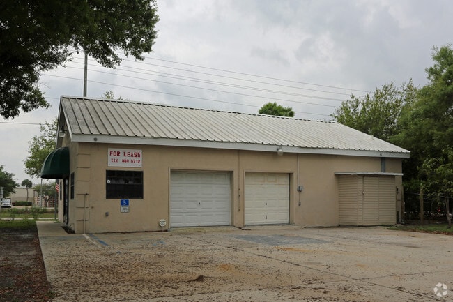
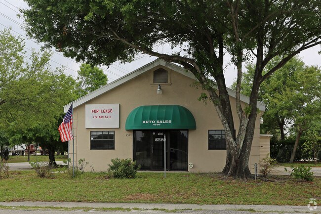
Property Record
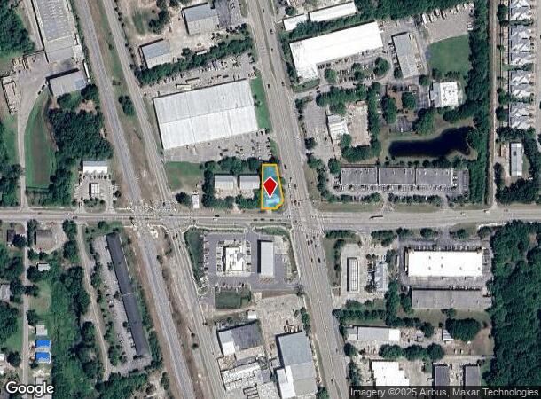
4505 Us Highway 1, Vero Beach, FL 32967
NEARBY LISTINGS FOR SALE OR LEASE
Property Detail
4505 Us Highway 1
32-39-23-00000-5000-00028.1
Null
Vehiclerentalsvehiclesales
SEC 23 TWN 32 RNG 39 THAT PART OF THE SE QTR OF THE SW QTR OF SEC 23 BEING MORE PART DESC AS FOLL BEG AT A POINT OF INTSCN WITH THE W ROW LINE OF US HIGHWAY NO 1 AND 209 FT N OF THE S LINE OF SAID SW QTR TH RUN S11-5642E AL THE SAID W ROW FOR A DIS O
X
Indian River
12061C0241H
Florida
2025
0.29 AC
2025
Fort Pierce/Port St Lucie
050305
Other Market Areas
1,632 SF
Sebastian-Vero Beach, FL
DEMOGRAPHICS near 4505 Us Highway 1
1 Mile
3 Mile
5 Mile
2024 Total Population
6,323
31,923
78,121
2029 Population
7,173
36,053
88,155
Pop Growth 2024-2029
+ 13.44%
+ 12.94%
+ 12.84%
Average Age
48
51
51
2024 Total Households
2,949
14,683
36,513
HH Growth 2024-2029
+ 13.26%
+ 12.73%
+ 12.63%
Median Household Inc
$55,686
$59,983
$59,861
Avg Household Size
2.10
2.10
2.00
2024 Avg HH Vehicles
1.00
2.00
2.00
Median Home Value
$198,834
$356,572
$323,548
Median Year Built
2001
1990
1987
Nearby Places
Map Layers
Map Styles
 Street
 Aerial
- Restaurants
- Banks
- Shops
- Fitness
- Groceries
PUBLIC TRANSPORTATION
AIRPORT
Melbourne Orlando International
DRIVE
WALK
Distance
Melbourne Orlando International
57 min
34.4 mi
Nearby Properties
Address
Land Use
TOTAL SIZE
Lot Size
Zoning
Address
Land Use
TOTAL SIZE
Lot Size
Zoning
634,259 SF
53.45 AC
MED
Address
Land Use
TOTAL SIZE
Lot Size
Zoning
571,211 SF
26.38 AC
RM-10
Address
Land Use
TOTAL SIZE
Lot Size
Zoning
240,516 SF
39.71 AC
RM-8
Address
Land Use
TOTAL SIZE
Lot Size
Zoning
39,873 SF
7.61 AC
GU
Address
Land Use
TOTAL SIZE
Lot Size
Zoning
2,133 SF
772.04 AC
ALI-A1
Address
Land Use
TOTAL SIZE
Lot Size
Zoning
46,567 SF
19.61 AC
CG
Address
Land Use
TOTAL SIZE
Lot Size
Zoning
125,677 SF
2.17 AC
DTW
Address
Land Use
TOTAL SIZE
Lot Size
Zoning
49,513 SF
60.64 AC
ALI-MC
Address
Land Use
TOTAL SIZE
Lot Size
Zoning
106,904 SF
79.05 AC
M
Address
Land Use
TOTAL SIZE
Lot Size
Zoning
124.80 AC
Address
Land Use
TOTAL SIZE
Lot Size
Zoning
80,682 SF
24.97 AC
R-1A
Address
Land Use
TOTAL SIZE
Lot Size
Zoning
235,921 SF
28.80 AC
RM-8
Address
Land Use
TOTAL SIZE
Lot Size
Zoning
67,334 SF
9.63 AC
MED
Address
Land Use
TOTAL SIZE
Lot Size
Zoning
149,178 SF
10.72 AC
C-1B
Address
Land Use
TOTAL SIZE
Lot Size
Zoning
8,087 SF
1.44 AC
R-1A
Address
Land Use
TOTAL SIZE
Lot Size
Zoning
69,942 SF
10.47 AC
MED
Address
Land Use
TOTAL SIZE
Lot Size
Zoning
6,949 SF
8.17 AC
P-2
Address
Land Use
TOTAL SIZE
Lot Size
Zoning
91,904 SF
10 AC
CG
Address
Land Use
TOTAL SIZE
Lot Size
Zoning
1,500 SF
34.50 AC
P-2
Address
Land Use
TOTAL SIZE
Lot Size
Zoning
2,232 SF
8.35 AC
C-1B
Address
Land Use
TOTAL SIZE
Lot Size
Zoning
5,268 SF
4.62 AC
R-1
Address
Land Use
TOTAL SIZE
Lot Size
Zoning
3,540 SF
217.55 AC
ALI-A2
Address
Land Use
TOTAL SIZE
Lot Size
Zoning
29,804 SF
498.76 AC
CON-1
Address
Land Use
TOTAL SIZE
Lot Size
Zoning
9,215 SF
4.58 AC
RM-10/12
Address
Land Use
TOTAL SIZE
Lot Size
Zoning
72,397 SF
10.45 AC
CG
Address
Land Use
TOTAL SIZE
Lot Size
Zoning
221.70 AC
MPZ
Address
Land Use
TOTAL SIZE
Lot Size
Zoning
4,742 SF
38.96 AC
RS-6
Address
Land Use
TOTAL SIZE
Lot Size
Zoning
94,187 SF
9.15 AC
MED
Address
Land Use
TOTAL SIZE
Lot Size
Zoning
0.92 AC
R-2A
Address
Land Use
TOTAL SIZE
Lot Size
Zoning
6,898 SF
1.18 AC
R-1A
The World's #1 Commercial Real Estate Marketplace
Connect with us
© 2025 CoStar Group
The information above has been obtained from sources believed reliable. While we do not doubt its accuracy we have not verified it and make no guarantee, warranty or representation about it. It is your responsibility to independently confirm its accuracy and completeness. Any projections, opinions, assumptions, or estimates used are for example only and do not represent the current or future performance of the property. The value of this transaction to you depends on tax and other factors which should be evaluated by your tax, financial, and legal advisors. You and your advisors should conduct a careful, independent investigation of the property to determine to your satisfaction the suitability of the property for your needs.