Property Record
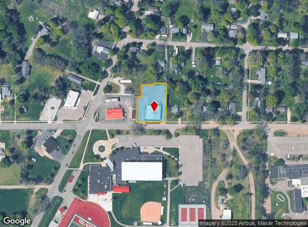
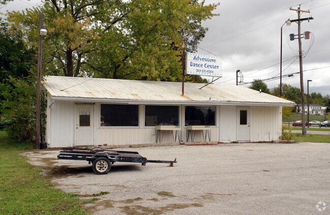
4506 W Butterfield Hwy, Olivet, MI 49076

NEARBY LISTINGS FOR SALE OR LEASE
-
-
View all Olivet listings for sale on LoopNet.com
Property Detail
4506 W Butterfield Hwy
Lansing-East Lansing, MI
Hosfords Second Addition
600-050-600-311-01
E 25 FT OF LOTS 29 & 30. LOT 31 & 32. HOSFORDS SECOND ADDITION, CITY OF OLIVET. D 4-4-14 (COMBINATION) COMBINED FROM 600-050-600-311-00 & 600-050-600-320-00 FOR 2015.
Wholesaleoutletdiscountstore
Eaton
X
Michigan
26025C0095C
29-32
2024
0.81 AC
2025
Outlying Eaton County
021100
West Michigan
6,396 SF
DEMOGRAPHICS near 4506 W Butterfield Hwy
1 Mile
3 Mile
5 Mile
2024 Total Population
1,992
3,401
7,011
2029 Population
2,013
3,422
7,027
Pop Growth 2024-2029
+ 1.05%
+ 0.62%
+ 0.23%
Average Age
33
37
39
2024 Total Households
534
1,060
2,461
HH Growth 2024-2029
+ 1.87%
+ 0.85%
+ 0.33%
Median Household Inc
$47,621
$57,791
$63,336
Avg Household Size
2.50
2.60
2.50
2024 Avg HH Vehicles
2.00
2.00
2.00
Median Home Value
$172,793
$188,720
$193,936
Median Year Built
1963
1969
1970
Nearby Places
Map Layers
Map Styles
 Street
 Aerial
- Restaurants
- Banks
- Shops
- Fitness
- Groceries
PUBLIC TRANSPORTATION
AIRPORT
Capital Region International
DRIVE
WALK
Distance
Capital Region International
43 min
34.1 mi
Freight Ports
Port of Toledo
DRIVE
WALK
Distance
Port of Toledo
155 min
121.4 mi
Nearby Properties
Address
Land Use
TOTAL SIZE
Lot Size
Zoning
Address
Land Use
TOTAL SIZE
Lot Size
Zoning
10,504 SF
1.49 AC
Address
Land Use
TOTAL SIZE
Lot Size
Zoning
Address
Land Use
TOTAL SIZE
Lot Size
Zoning
1.70 AC
Address
Land Use
TOTAL SIZE
Lot Size
Zoning
2,464 SF
179.20 AC
LA
Address
Land Use
TOTAL SIZE
Lot Size
Zoning
4,968 SF
0.16 AC
Address
Land Use
TOTAL SIZE
Lot Size
Zoning
2,235 SF
170 AC
LA
Address
Land Use
TOTAL SIZE
Lot Size
Zoning
760 SF
3.99 AC
Address
Land Use
TOTAL SIZE
Lot Size
Zoning
1,840 SF
164 AC
LA
Address
Land Use
TOTAL SIZE
Lot Size
Zoning
107.30 AC
AG
Address
Land Use
TOTAL SIZE
Lot Size
Zoning
4,800 SF
0.74 AC
Address
Land Use
TOTAL SIZE
Lot Size
Zoning
41,000 SF
6.80 AC
I
Address
Land Use
TOTAL SIZE
Lot Size
Zoning
1,528 SF
160 AC
LA
Address
Land Use
TOTAL SIZE
Lot Size
Zoning
2,581 SF
0.53 AC
Address
Land Use
TOTAL SIZE
Lot Size
Zoning
17,890 SF
1.55 AC
Address
Land Use
TOTAL SIZE
Lot Size
Zoning
4,476 SF
0.20 AC
Address
Land Use
TOTAL SIZE
Lot Size
Zoning
3.10 AC
Address
Land Use
TOTAL SIZE
Lot Size
Zoning
3,638 SF
40 AC
LA
Address
Land Use
TOTAL SIZE
Lot Size
Zoning
9,376 SF
0.88 AC
Address
Land Use
TOTAL SIZE
Lot Size
Zoning
1.74 AC
Address
Land Use
TOTAL SIZE
Lot Size
Zoning
1,624 SF
80 AC
LA
Address
Land Use
TOTAL SIZE
Lot Size
Zoning
112.15 AC
LA
Address
Land Use
TOTAL SIZE
Lot Size
Zoning
4,600 SF
0.76 AC
Address
Land Use
TOTAL SIZE
Lot Size
Zoning
1,578 SF
100 AC
LA
Address
Land Use
TOTAL SIZE
Lot Size
Zoning
1,636 SF
79.24 AC
LA
Address
Land Use
TOTAL SIZE
Lot Size
Zoning
145 AC
AGRICULTUR
Address
Land Use
TOTAL SIZE
Lot Size
Zoning
2,504 SF
85.17 AC
LA
Address
Land Use
TOTAL SIZE
Lot Size
Zoning
19,000 SF
1.75 AC
I
Address
Land Use
TOTAL SIZE
Lot Size
Zoning
120 AC
LA
Address
Land Use
TOTAL SIZE
Lot Size
Zoning
7,875 SF
0.32 AC
Address
Land Use
TOTAL SIZE
Lot Size
Zoning
2,825 SF
80 AC
LA
The World's #1 Commercial Real Estate Marketplace
Connect with us
© 2025 CoStar Group
The information above has been obtained from sources believed reliable. While we do not doubt its accuracy we have not verified it and make no guarantee, warranty or representation about it. It is your responsibility to independently confirm its accuracy and completeness. Any projections, opinions, assumptions, or estimates used are for example only and do not represent the current or future performance of the property. The value of this transaction to you depends on tax and other factors which should be evaluated by your tax, financial, and legal advisors. You and your advisors should conduct a careful, independent investigation of the property to determine to your satisfaction the suitability of the property for your needs.