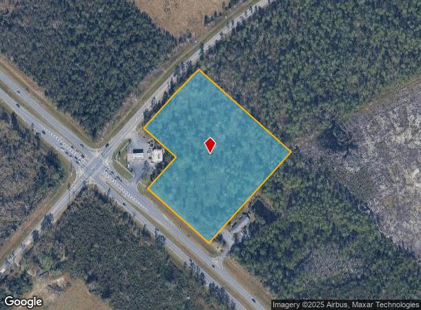
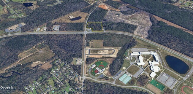
Property Record
4507 Perimeter Rd, , GA

This Property Is For Sale
NEARBY LISTINGS FOR SALE OR LEASE
Property Detail
4507 Perimeter Rd
Valdosta, GA
Perimeter-Park Ave Area To Hunt
0150-085
LT 25
Commercialacreage
Lowndes
X
Georgia
13173C0175C
25
2024
7.37 AC
2024
Valdosta/Lake Park
0107002066
Other Market Areas
DEMOGRAPHICS near 4507 Perimeter Rd
1 Mile
3 Mile
5 Mile
2024 Total Population
638
25,715
65,231
2029 Population
668
26,713
67,766
Pop Growth 2024-2029
+ 4.70%
+ 3.88%
+ 3.89%
Average Age
35
34
35
2024 Total Households
233
9,980
25,272
HH Growth 2024-2029
+ 4.72%
+ 4.00%
+ 4.06%
Median Household Inc
$45,921
$34,610
$36,756
Avg Household Size
2.70
2.50
2.40
2024 Avg HH Vehicles
2.00
2.00
2.00
Median Home Value
$146,250
$124,979
$162,400
Median Year Built
1999
1991
1989
Nearby Places
Map Layers
Map Styles
 Street
 Aerial
- Restaurants
- Banks
- Shops
- Fitness
- Groceries
PUBLIC TRANSPORTATION
AIRPORT
Valdosta Regional
DRIVE
WALK
Distance
Valdosta Regional
13 min
9.3 mi
Freight Ports
Georgia Ports - Brunswick
DRIVE
WALK
Distance
Georgia Ports - Brunswick
150 min
114.3 mi
Nearby Properties
Address
Land Use
TOTAL SIZE
Lot Size
Zoning
Address
Land Use
TOTAL SIZE
Lot Size
Zoning
60,000 SF
56.32 AC
M-1
Address
Land Use
TOTAL SIZE
Lot Size
Zoning
39,024 SF
18.04 AC
P-D
Address
Land Use
TOTAL SIZE
Lot Size
Zoning
339 SF
23.53 AC
E-R
Address
Land Use
TOTAL SIZE
Lot Size
Zoning
2,574 SF
12 AC
R-P
Address
Land Use
TOTAL SIZE
Lot Size
Zoning
24,928 SF
10 AC
R-M
Address
Land Use
TOTAL SIZE
Lot Size
Zoning
65,664 SF
16.06 AC
R-M
Address
Land Use
TOTAL SIZE
Lot Size
Zoning
7,200 SF
9.92 AC
M-1
Address
Land Use
TOTAL SIZE
Lot Size
Zoning
40,800 SF
5.83 AC
R-P
Address
Land Use
TOTAL SIZE
Lot Size
Zoning
53,880 SF
8.01 AC
C-H,C-C
Address
Land Use
TOTAL SIZE
Lot Size
Zoning
166,300 SF
43.05 AC
M-2
Address
Land Use
TOTAL SIZE
Lot Size
Zoning
49,546 SF
10.45 AC
R-P
Address
Land Use
TOTAL SIZE
Lot Size
Zoning
202,062 SF
7.12 AC
R-15
Address
Land Use
TOTAL SIZE
Lot Size
Zoning
25,727 SF
9.12 AC
R-A
Address
Land Use
TOTAL SIZE
Lot Size
Zoning
103,468 SF
9.38 AC
C-H
Address
Land Use
TOTAL SIZE
Lot Size
Zoning
9,000 SF
72.18 AC
E-A
Address
Land Use
TOTAL SIZE
Lot Size
Zoning
22,906 SF
3.25 AC
C-C
Address
Land Use
TOTAL SIZE
Lot Size
Zoning
18,936 SF
6.45 AC
R-M
Address
Land Use
TOTAL SIZE
Lot Size
Zoning
66,395 SF
1.49 AC
M-1
Address
Land Use
TOTAL SIZE
Lot Size
Zoning
40,343 SF
49.11 AC
R-6
Address
Land Use
TOTAL SIZE
Lot Size
Zoning
66.89 AC
C-H
Address
Land Use
TOTAL SIZE
Lot Size
Zoning
90,710 SF
33.43 AC
PRD-10
Address
Land Use
TOTAL SIZE
Lot Size
Zoning
3,360 SF
7.41 AC
C-G
Address
Land Use
TOTAL SIZE
Lot Size
Zoning
14,464 SF
4.01 AC
R-M
Address
Land Use
TOTAL SIZE
Lot Size
Zoning
38,352 SF
5.68 AC
R-P
Address
Land Use
TOTAL SIZE
Lot Size
Zoning
37,321 SF
6.35 AC
R-P
Address
Land Use
TOTAL SIZE
Lot Size
Zoning
15,343 SF
7 AC
C-C
Address
Land Use
TOTAL SIZE
Lot Size
Zoning
17,920 SF
6 AC
R-M
Address
Land Use
TOTAL SIZE
Lot Size
Zoning
23,549 SF
4.07 AC
C-H
Address
Land Use
TOTAL SIZE
Lot Size
Zoning
27,622 SF
3.43 AC
C-H
Address
Land Use
TOTAL SIZE
Lot Size
Zoning
8,000 SF
18.89 AC
M-1
The World's #1 Commercial Real Estate Marketplace
Connect with us
© 2025 CoStar Group
The information above has been obtained from sources believed reliable. While we do not doubt its accuracy we have not verified it and make no guarantee, warranty or representation about it. It is your responsibility to independently confirm its accuracy and completeness. Any projections, opinions, assumptions, or estimates used are for example only and do not represent the current or future performance of the property. The value of this transaction to you depends on tax and other factors which should be evaluated by your tax, financial, and legal advisors. You and your advisors should conduct a careful, independent investigation of the property to determine to your satisfaction the suitability of the property for your needs.