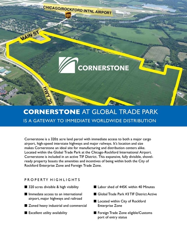
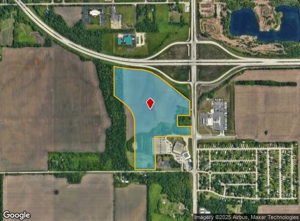
Property Record
47Xx S Main St, Rockford, IL 61102
NEARBY LISTINGS FOR SALE OR LEASE
Property Detail
47Xx S Main St
15-10-301-005
ASSR PLAT SW1/4 SEC 10-43-1 COMM NE COR SW1/4 TH W APPROX 853.46 FT TO POB TH N 340 FT NW APPROX 950.39 FT NW 171.37 FT NW 105.95 FT NW 133.09 FT NW 674
Agriculturalland
Winnebago
X
Illinois
17201C0378E
56.37 AC
2024
I-39 Corr/Winnebago Cnty
2024
Chicago
002200
Rockford, IL
DEMOGRAPHICS near 47Xx S Main St
1 Mile
3 Mile
5 Mile
2024 Total Population
746
21,359
94,994
2029 Population
741
21,138
94,444
Pop Growth 2024-2029
(0.67%)
(1.03%)
(0.58%)
Average Age
43
38
37
2024 Total Households
319
8,258
37,808
HH Growth 2024-2029
(0.63%)
(1.03%)
(0.64%)
Median Household Inc
$36,875
$36,923
$38,974
Avg Household Size
2.30
2.50
2.40
2024 Avg HH Vehicles
2.00
2.00
2.00
Median Home Value
$68,852
$79,859
$82,459
Median Year Built
1966
1955
1957
Nearby Places
Map Layers
Map Styles
 Street
 Aerial
- Restaurants
- Banks
- Shops
- Fitness
- Groceries
PUBLIC TRANSPORTATION
AIRPORT
Chicago/Rockford International
DRIVE
WALK
Distance
Chicago/Rockford International
11 min
4.4 mi
Freight Ports
Port Milwaukee
DRIVE
WALK
Distance
Port Milwaukee
116 min
99.4 mi
SALE & LEASE HISTORY
LISTING DATE
SALE/LEASE

Oct 02, 2017
For Sale
Nearby Properties
Address
Land Use
TOTAL SIZE
Lot Size
Zoning
Address
Land Use
TOTAL SIZE
Lot Size
Zoning
1,456,216 SF
103.10 AC
I1
Address
Land Use
TOTAL SIZE
Lot Size
Zoning
555,920 SF
37.99 AC
I2
Address
Land Use
TOTAL SIZE
Lot Size
Zoning
13,308 SF
19.30 AC
I2
Address
Land Use
TOTAL SIZE
Lot Size
Zoning
369,006 SF
15.24 AC
I2
Address
Land Use
TOTAL SIZE
Lot Size
Zoning
291,074 SF
10.97 AC
I3
Address
Land Use
TOTAL SIZE
Lot Size
Zoning
189,455 SF
10.99 AC
I3
Address
Land Use
TOTAL SIZE
Lot Size
Zoning
173,193 SF
5.97 AC
I3
Address
Land Use
TOTAL SIZE
Lot Size
Zoning
43.23 AC
I1
Address
Land Use
TOTAL SIZE
Lot Size
Zoning
192,575 SF
46.19 AC
I1
Address
Land Use
TOTAL SIZE
Lot Size
Zoning
192,476 SF
30.63 AC
I2
Address
Land Use
TOTAL SIZE
Lot Size
Zoning
623,379 SF
35.15 AC
I3
Address
Land Use
TOTAL SIZE
Lot Size
Zoning
189,568 SF
12.68 AC
I1
Address
Land Use
TOTAL SIZE
Lot Size
Zoning
58,750 SF
11.25 AC
I1
Address
Land Use
TOTAL SIZE
Lot Size
Zoning
2,975 SF
5.42 AC
I2
Address
Land Use
TOTAL SIZE
Lot Size
Zoning
212,574 SF
9.57 AC
I3
Address
Land Use
TOTAL SIZE
Lot Size
Zoning
150,351 SF
22.95 AC
I3
Address
Land Use
TOTAL SIZE
Lot Size
Zoning
10,970 SF
26.80 AC
R2
Address
Land Use
TOTAL SIZE
Lot Size
Zoning
151,360 SF
8.13 AC
I1
Address
Land Use
TOTAL SIZE
Lot Size
Zoning
584,794 SF
34.40 AC
I3
Address
Land Use
TOTAL SIZE
Lot Size
Zoning
152,100 SF
4.19 AC
I2
Address
Land Use
TOTAL SIZE
Lot Size
Zoning
216,549 SF
9.18 AC
I2
Address
Land Use
TOTAL SIZE
Lot Size
Zoning
6,869 SF
93.78 AC
RMH
Address
Land Use
TOTAL SIZE
Lot Size
Zoning
187,025 SF
12.82 AC
I3
Address
Land Use
TOTAL SIZE
Lot Size
Zoning
92,245 SF
5.67 AC
I3
Address
Land Use
TOTAL SIZE
Lot Size
Zoning
144,088 SF
12.01 AC
I1
Address
Land Use
TOTAL SIZE
Lot Size
Zoning
206,185 SF
21.09 AC
I3
Address
Land Use
TOTAL SIZE
Lot Size
Zoning
165,326 SF
26.32 AC
I3
Address
Land Use
TOTAL SIZE
Lot Size
Zoning
203,450 SF
31.79 AC
I3
Address
Land Use
TOTAL SIZE
Lot Size
Zoning
80,884 SF
5.34 AC
I1
Address
Land Use
TOTAL SIZE
Lot Size
Zoning
79,642 SF
10.56 AC
I1
The World's #1 Commercial Real Estate Marketplace
Connect with us
© 2025 CoStar Group
The information above has been obtained from sources believed reliable. While we do not doubt its accuracy we have not verified it and make no guarantee, warranty or representation about it. It is your responsibility to independently confirm its accuracy and completeness. Any projections, opinions, assumptions, or estimates used are for example only and do not represent the current or future performance of the property. The value of this transaction to you depends on tax and other factors which should be evaluated by your tax, financial, and legal advisors. You and your advisors should conduct a careful, independent investigation of the property to determine to your satisfaction the suitability of the property for your needs.