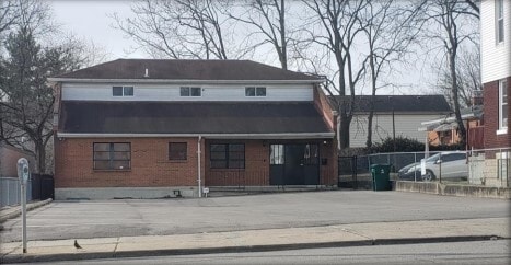
Property Record
4507 W 8Th St, Cincinnati, OH 45238

Save to a Folder
{{folder.Name}}
{{folder.ListingIds.length}} Properties
{{folder.ListingIds.length}} Property
Create a New Folder
Property Detail
4507 W 8Th St
180-0082-0037
4507 W EIGHTH ST 50 X 150 LOT 5 SIMON OEHLER EST
Officebuilding
Hamilton
CCM
Ohio
B and X Area of moderate flood hazard, usually the area between the limits of the 100-year and 500-year floods.
5
2025
0.17 AC
2025
Queensgate
009902
Cincinnati/Dayton
3,132 SF
Cincinnati, OH-KY-IN
NEARBY LISTINGS FOR SALE OR LEASE
DEMOGRAPHICS near 4507 W 8Th St
1 mile
3 mile
5 mile
2025 Total Population
17,328
106,283
246,728
2030 Population
17,305
107,554
251,526
Pop Growth 2025-2030
(0.13%)
+ 1.20%
+ 1.94%
Average Age
37
38
37
2025 Total Households
7,018
42,495
103,039
HH Growth 2025-2030
(0.06%)
+ 1.22%
+ 2.13%
Median Household Inc
$62,802
$56,896
$60,763
Avg Household Size
2.40
2.40
2.20
2025 Avg HH Vehicles
2.00
2.00
2.00
Median Home Value
$155,071
$178,535
$219,409
Median Year Built
1951
1958
1959
Nearby Places
Map Layers
Map Styles
 Street
 Aerial
Layers
 Traffic
 Biking
Places
Listings with unknown addresses are not visible on the map
- Restaurants
- Banks
- Shops
- Fitness
- Groceries
PUBLIC TRANSPORTATION
COMMUTER RAIL
Cincinnati Union Terminal (Cardinal - Amtrak)
Drive
Walk
Distance
Cincinnati Union Terminal (Cardinal - Amtrak)
12 min
4.9 mi
AIRPORT
Cincinnati/Northern Kentucky International
Drive
Walk
Distance
Cincinnati/Northern Kentucky International
35 min
18.6 mi
Freight Ports
Port of Toledo
Drive
Walk
Distance
Port of Toledo
249 min
208.8 mi
SALE & LEASE HISTORY
LISTING DATE
SALE/LEASE

Mar 07, 2022
For Sale
Nearby Properties
Address
Land Use
TOTAL SIZE
Lot Size
Zoning
Address
Land Use
TOTAL SIZE
Lot Size
Zoning
46.68 AC
Address
Land Use
TOTAL SIZE
Lot Size
Zoning
99.35 AC
Address
Land Use
TOTAL SIZE
Lot Size
Zoning
30.43 AC
AA
Address
Land Use
TOTAL SIZE
Lot Size
Zoning
17,857 SF
26.60 AC
CGA
Address
Land Use
TOTAL SIZE
Lot Size
Zoning
23.05 AC
Address
Land Use
TOTAL SIZE
Lot Size
Zoning
12.28 AC
AA
Address
Land Use
TOTAL SIZE
Lot Size
Zoning
8.18 AC
SF4
Address
Land Use
TOTAL SIZE
Lot Size
Zoning
77,628 SF
2.18 AC
Address
Land Use
TOTAL SIZE
Lot Size
Zoning
13.44 AC
Address
Land Use
TOTAL SIZE
Lot Size
Zoning
50,350 SF
15.41 AC
MG
Address
Land Use
TOTAL SIZE
Lot Size
Zoning
Address
Land Use
TOTAL SIZE
Lot Size
Zoning
6,537 SF
12.55 AC
Address
Land Use
TOTAL SIZE
Lot Size
Zoning
1,873 SF
12.20 AC
Address
Land Use
TOTAL SIZE
Lot Size
Zoning
25,795 SF
31.93 AC
DD
Address
Land Use
TOTAL SIZE
Lot Size
Zoning
12.72 AC
DD
Address
Land Use
TOTAL SIZE
Lot Size
Zoning
125,405 SF
16.69 AC
SF6
Address
Land Use
TOTAL SIZE
Lot Size
Zoning
6,000 SF
11.92 AC
G
Address
Land Use
TOTAL SIZE
Lot Size
Zoning
7.33 AC
Address
Land Use
TOTAL SIZE
Lot Size
Zoning
62,160 SF
13.70 AC
RM20
Address
Land Use
TOTAL SIZE
Lot Size
Zoning
4.60 AC
SF6
Address
Land Use
TOTAL SIZE
Lot Size
Zoning
55,572 SF
6.12 AC
C
Address
Land Use
TOTAL SIZE
Lot Size
Zoning
169,636 SF
20.22 AC
IR
Address
Land Use
TOTAL SIZE
Lot Size
Zoning
14.01 AC
CGA
Address
Land Use
TOTAL SIZE
Lot Size
Zoning
1,329 SF
3.16 AC
SF4
Address
Land Use
TOTAL SIZE
Lot Size
Zoning
82.94 AC
Address
Land Use
TOTAL SIZE
Lot Size
Zoning
19,730 SF
0.16 AC
SF2
Address
Land Use
TOTAL SIZE
Lot Size
Zoning
3,654 SF
10.82 AC
E
Address
Land Use
TOTAL SIZE
Lot Size
Zoning
2,400 SF
1.49 AC
MG
Address
Land Use
TOTAL SIZE
Lot Size
Zoning
12,600 SF
0.62 AC
Address
Land Use
TOTAL SIZE
Lot Size
Zoning
40,080 SF
4.14 AC
SF6
The World's #1 Commercial Real Estate Marketplace
Connect with us
© 2026 CoStar Group
The information above has been obtained from sources believed reliable. While we do not doubt its accuracy we have not verified it and make no guarantee, warranty or representation about it. It is your responsibility to independently confirm its accuracy and completeness. Any projections, opinions, assumptions, or estimates used are for example only and do not represent the current or future performance of the property. The value of this transaction to you depends on tax and other factors which should be evaluated by your tax, financial, and legal advisors. You and your advisors should conduct a careful, independent investigation of the property to determine to your satisfaction the suitability of the property for your needs.