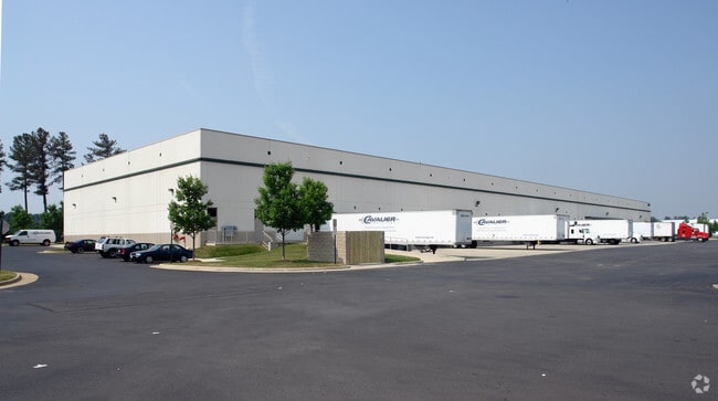
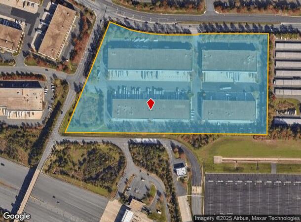
Property Record
45085 Old Ox Rd, Sterling, VA 20166


NEARBY LISTINGS FOR SALE OR LEASE
Property Detail
45085 Old Ox Rd
046-27-5921
Horsepen
Warehouse
HORSEPEN (TRACT 1) 1948--705 1336--959 HWY 1832--763 PC F-9
X
Loudoun
51107C0380E
Virginia
2025
16.16 AC
2025
Rt 28/Dulles North
980100
Washington, DC
208,280 SF
Washington-Arlington-Alexandria, DC-VA-MD-WV
DEMOGRAPHICS near 45085 Old Ox Rd
1 mile
3 mile
5 mile
2024 Total Population
4
68,448
237,679
2029 Population
5
70,183
247,556
Pop Growth 2024-2029
+ 25.00%
+ 2.53%
+ 4.16%
Average Age
0
35
37
2024 Total Households
1
23,095
83,363
HH Growth 2024-2029
+ 100.00%
+ 2.61%
+ 4.16%
Median Household Inc
$87,500
$114,493
$139,859
Avg Household Size
.00
2.80
2.80
2024 Avg HH Vehicles
2.00
2.00
2.00
Median Home Value
$750,000
$477,632
$641,399
Median Year Built
2011
1993
1997
Nearby Places
Map Layers
Map Styles
 Street
 Aerial
Transit
 Traffic
 Biking
Places
Listings with unknown addresses are not visible on the map
- Restaurants
- Banks
- Shops
- Fitness
- Groceries
PUBLIC TRANSPORTATION
AIRPORT
Washington Dulles International
Drive
Walk
Distance
Washington Dulles International
12 min
4.2 mi
Ronald Reagan Washington Ntl
Drive
Walk
Distance
Ronald Reagan Washington Ntl
45 min
29.3 mi
Freight Ports
Port of Baltimore
Drive
Walk
Distance
Port of Baltimore
82 min
61.2 mi
Nearby Properties
Address
Land Use
TOTAL SIZE
Lot Size
Zoning
Address
Land Use
TOTAL SIZE
Lot Size
Zoning
1,137,740 SF
38.21 AC
PDOP
Address
Land Use
TOTAL SIZE
Lot Size
Zoning
2,700,000 SF
7.51 AC
PDGI
Address
Land Use
TOTAL SIZE
Lot Size
Zoning
438,460 SF
10.85 AC
OP
Address
Land Use
TOTAL SIZE
Lot Size
Zoning
462,210 SF
PDOP
Address
Land Use
TOTAL SIZE
Lot Size
Zoning
521,784 SF
PDOP
Address
Land Use
TOTAL SIZE
Lot Size
Zoning
800,702 SF
111.70 AC
PDIP
Address
Land Use
TOTAL SIZE
Lot Size
Zoning
789,350 SF
31.73 AC
PDOP
Address
Land Use
TOTAL SIZE
Lot Size
Zoning
368,624 SF
8.85 AC
PDOP
Address
Land Use
TOTAL SIZE
Lot Size
Zoning
234,124 SF
23.84 AC
PDOP
Address
Land Use
TOTAL SIZE
Lot Size
Zoning
679,455 SF
31.97 AC
PDIP
Address
Land Use
TOTAL SIZE
Lot Size
Zoning
427,320 SF
16.33 AC
PDIP
Address
Land Use
TOTAL SIZE
Lot Size
Zoning
364,600 SF
PDOP
Address
Land Use
TOTAL SIZE
Lot Size
Zoning
784,204 SF
128.54 AC
GI
Address
Land Use
TOTAL SIZE
Lot Size
Zoning
302,180 SF
10.92 AC
PDOP
Address
Land Use
TOTAL SIZE
Lot Size
Zoning
310,717 SF
14.30 AC
PDOP
Address
Land Use
TOTAL SIZE
Lot Size
Zoning
288,403 SF
16.56 AC
PDOP
Address
Land Use
TOTAL SIZE
Lot Size
Zoning
286,865 SF
18.56 AC
IP
Address
Land Use
TOTAL SIZE
Lot Size
Zoning
493,504 SF
15.73 AC
PDOP
Address
Land Use
TOTAL SIZE
Lot Size
Zoning
308,630 SF
14.44 AC
PDIP
Address
Land Use
TOTAL SIZE
Lot Size
Zoning
147,260 SF
33.04 AC
PDIP
Address
Land Use
TOTAL SIZE
Lot Size
Zoning
565,680 SF
18.44 AC
PDIP
Address
Land Use
TOTAL SIZE
Lot Size
Zoning
228,606 SF
PDOP
Address
Land Use
TOTAL SIZE
Lot Size
Zoning
1,434,706 SF
96.74 AC
PDRDP
Address
Land Use
TOTAL SIZE
Lot Size
Zoning
455,793 SF
22.60 AC
IP
Address
Land Use
TOTAL SIZE
Lot Size
Zoning
180,355 SF
12.89 AC
PDIP
Address
Land Use
TOTAL SIZE
Lot Size
Zoning
362,108 SF
18.82 AC
PDOP
Address
Land Use
TOTAL SIZE
Lot Size
Zoning
764,166 SF
73.90 AC
PDIP
Address
Land Use
TOTAL SIZE
Lot Size
Zoning
226,456 SF
17.09 AC
PDIP
Address
Land Use
TOTAL SIZE
Lot Size
Zoning
364,650 SF
PDOP
Address
Land Use
TOTAL SIZE
Lot Size
Zoning
253,352 SF
PDOP
The World's #1 Commercial Real Estate Marketplace
Connect with us
© 2026 CoStar Group
The information above has been obtained from sources believed reliable. While we do not doubt its accuracy we have not verified it and make no guarantee, warranty or representation about it. It is your responsibility to independently confirm its accuracy and completeness. Any projections, opinions, assumptions, or estimates used are for example only and do not represent the current or future performance of the property. The value of this transaction to you depends on tax and other factors which should be evaluated by your tax, financial, and legal advisors. You and your advisors should conduct a careful, independent investigation of the property to determine to your satisfaction the suitability of the property for your needs.