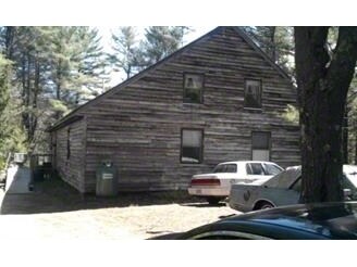
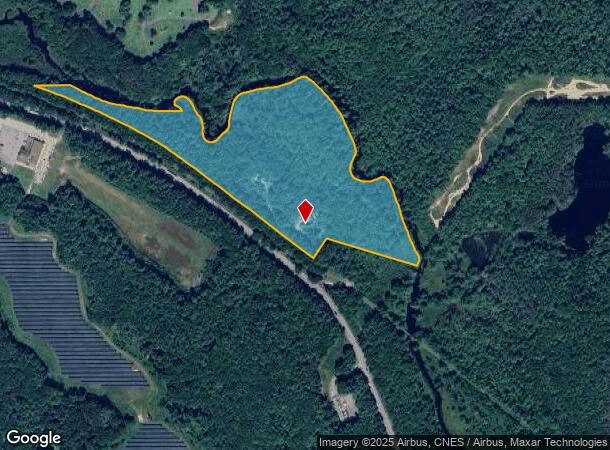
Property Record
450R Spring St, Winchendon, MA 01475
NEARBY LISTINGS FOR SALE OR LEASE
-
-
View all Winchendon listings for sale on LoopNet.com
Property Detail
450R Spring St
WINC-000006-000000-000070
Worcester
Commercialofficeresidentialmixeduse
Massachusetts
ARE
70
25027C0066E
17 AC
2025
Outlying Worcester
2025
Boston
701101
Worcester, MA-CT
2,700 SF
DEMOGRAPHICS near 450R Spring St
1 Mile
3 Mile
5 Mile
2024 Total Population
789
9,788
17,166
2029 Population
789
9,855
17,431
Pop Growth 2024-2029
0.00%
+ 0.68%
+ 1.54%
Average Age
41
42
42
2024 Total Households
307
3,789
6,529
HH Growth 2024-2029
0.00%
+ 0.66%
+ 1.47%
Median Household Inc
$96,527
$92,557
$96,346
Avg Household Size
2.40
2.50
2.50
2024 Avg HH Vehicles
2.00
2.00
2.00
Median Home Value
$246,478
$277,606
$291,111
Median Year Built
1980
1982
1983
Nearby Places
Map Layers
Map Styles
 Street
 Aerial
- Restaurants
- Banks
- Shops
- Fitness
- Groceries
PUBLIC TRANSPORTATION
AIRPORT
Worcester Regional
DRIVE
WALK
Distance
Worcester Regional
62 min
39.5 mi
Freight Ports
Port of Boston
DRIVE
WALK
Distance
Port of Boston
95 min
65.8 mi
Nearby Properties
Address
Land Use
TOTAL SIZE
Lot Size
Zoning
Address
Land Use
TOTAL SIZE
Lot Size
Zoning
36.05 AC
R3
Address
Land Use
TOTAL SIZE
Lot Size
Zoning
92,819 SF
79.50 AC
R4
Address
Land Use
TOTAL SIZE
Lot Size
Zoning
116,964 SF
7.60 AC
R4
Address
Land Use
TOTAL SIZE
Lot Size
Zoning
8.25 AC
C3
Address
Land Use
TOTAL SIZE
Lot Size
Zoning
55,284 SF
8.25 AC
I
Address
Land Use
TOTAL SIZE
Lot Size
Zoning
26.70 AC
R4
Address
Land Use
TOTAL SIZE
Lot Size
Zoning
28,039 SF
7 AC
R4
Address
Land Use
TOTAL SIZE
Lot Size
Zoning
10.04 AC
R3
Address
Land Use
TOTAL SIZE
Lot Size
Zoning
27,685 SF
1.72 AC
R4
Address
Land Use
TOTAL SIZE
Lot Size
Zoning
11.69 AC
I
Address
Land Use
TOTAL SIZE
Lot Size
Zoning
2.25 AC
C3
Address
Land Use
TOTAL SIZE
Lot Size
Zoning
6 AC
I
Address
Land Use
TOTAL SIZE
Lot Size
Zoning
11.08 AC
R4
Address
Land Use
TOTAL SIZE
Lot Size
Zoning
401.50 AC
Address
Land Use
TOTAL SIZE
Lot Size
Zoning
4,866 SF
106.88 AC
R3
Address
Land Use
TOTAL SIZE
Lot Size
Zoning
13,462 SF
1.67 AC
C3
Address
Land Use
TOTAL SIZE
Lot Size
Zoning
18,300 SF
4.50 AC
C1
Address
Land Use
TOTAL SIZE
Lot Size
Zoning
16,000 SF
3.77 AC
C3
Address
Land Use
TOTAL SIZE
Lot Size
Zoning
2.44 AC
R4
Address
Land Use
TOTAL SIZE
Lot Size
Zoning
14,860 SF
2.71 AC
R4
Address
Land Use
TOTAL SIZE
Lot Size
Zoning
4.46 AC
Address
Land Use
TOTAL SIZE
Lot Size
Zoning
164,674 SF
1.40 AC
C2
Address
Land Use
TOTAL SIZE
Lot Size
Zoning
2.14 AC
R3
Address
Land Use
TOTAL SIZE
Lot Size
Zoning
489.75 AC
R2
Address
Land Use
TOTAL SIZE
Lot Size
Zoning
10,708 SF
1.11 AC
C3
Address
Land Use
TOTAL SIZE
Lot Size
Zoning
0.53 AC
C3
Address
Land Use
TOTAL SIZE
Lot Size
Zoning
5,952 SF
0.78 AC
C3
Address
Land Use
TOTAL SIZE
Lot Size
Zoning
13,920 SF
1.34 AC
C3
Address
Land Use
TOTAL SIZE
Lot Size
Zoning
8,945 SF
0.41 AC
R4
Address
Land Use
TOTAL SIZE
Lot Size
Zoning
52,200 SF
7 AC
The World's #1 Commercial Real Estate Marketplace
Connect with us
© 2025 CoStar Group
The information above has been obtained from sources believed reliable. While we do not doubt its accuracy we have not verified it and make no guarantee, warranty or representation about it. It is your responsibility to independently confirm its accuracy and completeness. Any projections, opinions, assumptions, or estimates used are for example only and do not represent the current or future performance of the property. The value of this transaction to you depends on tax and other factors which should be evaluated by your tax, financial, and legal advisors. You and your advisors should conduct a careful, independent investigation of the property to determine to your satisfaction the suitability of the property for your needs.