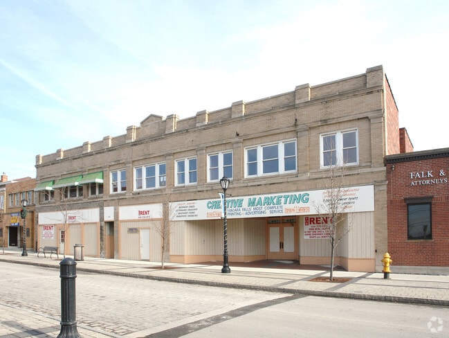
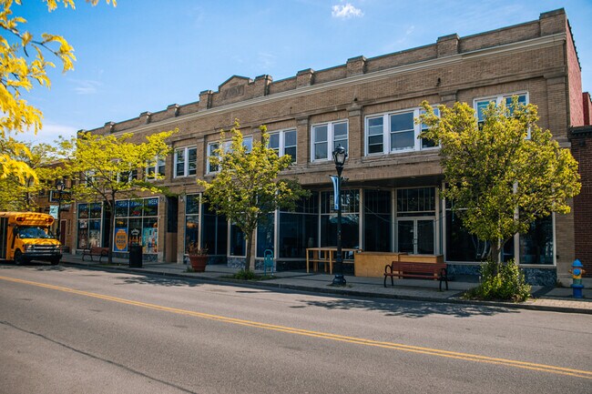
Property Record
451 3Rd St, Niagara Falls, NY 14301

Current Lease Availabilities
Property Detail
451 3Rd St
291100-159-029-0001-032-000
TM 16 BL G LOT 60 & S PT 62
Commercialofficeresidentialmixeduse
NIAGARA
C2-A
New York
B and X Area of moderate flood hazard, usually the area between the limits of the 100-year and 500-year floods.
32.000
2025
0.30 AC
2025
Niagara Falls
021100
Buffalo/Niagara Falls
12,045 SF
Buffalo-Cheektowaga, NY
NEARBY LISTINGS FOR SALE OR LEASE
DEMOGRAPHICS near 451 3Rd St
1 mile
3 mile
5 mile
2025 Total Population
8,401
33,736
53,186
2030 Population
8,603
33,666
52,911
Pop Growth 2025-2030
+ 2.40%
(0.21%)
(0.52%)
Average Age
42
40
41
2025 Total Households
4,003
14,988
23,117
HH Growth 2025-2030
+ 2.27%
(0.25%)
(0.55%)
Median Household Inc
$33,008
$41,386
$49,091
Avg Household Size
1.90
2.10
2.20
2025 Avg HH Vehicles
1.00
1.00
1.00
Median Home Value
$89,241
$94,363
$129,609
Median Year Built
1947
1947
1949
Nearby Places
Map Layers
Map Styles
 Street
 Aerial
Layers
 Traffic
 Biking
Places
Listings with unknown addresses are not visible on the map
- Restaurants
- Banks
- Shops
- Fitness
- Groceries
PUBLIC TRANSPORTATION
COMMUTER RAIL
Drive
Walk
Distance
4 min
1.5 mi
AIRPORT
Niagara Falls International
Drive
Walk
Distance
Niagara Falls International
15 min
6.7 mi
Buffalo Niagara International
Drive
Walk
Distance
Buffalo Niagara International
37 min
24.5 mi
Nearby Properties
Address
Land Use
TOTAL SIZE
Lot Size
Zoning
Address
Land Use
TOTAL SIZE
Lot Size
Zoning
305,119 SF
11.80 AC
D1-D
Address
Land Use
TOTAL SIZE
Lot Size
Zoning
34.59 AC
I2
Address
Land Use
TOTAL SIZE
Lot Size
Zoning
170.93 AC
OS
Address
Land Use
TOTAL SIZE
Lot Size
Zoning
14.70 AC
I2
Address
Land Use
TOTAL SIZE
Lot Size
Zoning
95,628 SF
5.10 AC
C2-A
Address
Land Use
TOTAL SIZE
Lot Size
Zoning
86,660 SF
11.60 AC
I2
Address
Land Use
TOTAL SIZE
Lot Size
Zoning
441,749 SF
20.54 AC
I2
Address
Land Use
TOTAL SIZE
Lot Size
Zoning
375,735 SF
6.90 AC
OS
Address
Land Use
TOTAL SIZE
Lot Size
Zoning
0.89 AC
I2
Address
Land Use
TOTAL SIZE
Lot Size
Zoning
6,496 SF
9.50 AC
INS
Address
Land Use
TOTAL SIZE
Lot Size
Zoning
18,829 SF
2.76 AC
OS
Address
Land Use
TOTAL SIZE
Lot Size
Zoning
64,006 SF
447.28 AC
OS
Address
Land Use
TOTAL SIZE
Lot Size
Zoning
Address
Land Use
TOTAL SIZE
Lot Size
Zoning
270,580 SF
2.10 AC
D1-A
Address
Land Use
TOTAL SIZE
Lot Size
Zoning
250,062 SF
2.60 AC
INS
Address
Land Use
TOTAL SIZE
Lot Size
Zoning
74,558 SF
1.90 AC
INS
Address
Land Use
TOTAL SIZE
Lot Size
Zoning
247.60 AC
Address
Land Use
TOTAL SIZE
Lot Size
Zoning
3.30 AC
D1-D
Address
Land Use
TOTAL SIZE
Lot Size
Zoning
628,572 SF
4.22 AC
D1-B
Address
Land Use
TOTAL SIZE
Lot Size
Zoning
2,000 SF
4.90 AC
D2
Address
Land Use
TOTAL SIZE
Lot Size
Zoning
Address
Land Use
TOTAL SIZE
Lot Size
Zoning
Address
Land Use
TOTAL SIZE
Lot Size
Zoning
106,800 SF
3.15 AC
D1-A
Address
Land Use
TOTAL SIZE
Lot Size
Zoning
296.91 AC
OS
Address
Land Use
TOTAL SIZE
Lot Size
Zoning
129,664 SF
5 AC
INS
Address
Land Use
TOTAL SIZE
Lot Size
Zoning
36,120 SF
83.58 AC
I1
Address
Land Use
TOTAL SIZE
Lot Size
Zoning
160,807 SF
3.80 AC
R4-A
Address
Land Use
TOTAL SIZE
Lot Size
Zoning
336 SF
15.90 AC
D1-D
Address
Land Use
TOTAL SIZE
Lot Size
Zoning
Address
Land Use
TOTAL SIZE
Lot Size
Zoning
7,528 SF
7.52 AC
06 - INDUS
The World's #1 Commercial Real Estate Marketplace
Connect with us
© 2026 CoStar Group
The information above has been obtained from sources believed reliable. While we do not doubt its accuracy we have not verified it and make no guarantee, warranty or representation about it. It is your responsibility to independently confirm its accuracy and completeness. Any projections, opinions, assumptions, or estimates used are for example only and do not represent the current or future performance of the property. The value of this transaction to you depends on tax and other factors which should be evaluated by your tax, financial, and legal advisors. You and your advisors should conduct a careful, independent investigation of the property to determine to your satisfaction the suitability of the property for your needs.