Property Record
451 Mccormick Rd, Coraopolis, PA 15108


NEARBY LISTINGS FOR SALE OR LEASE
Property Detail
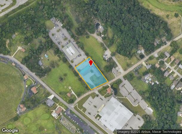
451 Mccormick Rd
Pittsburgh, PA
Chl Development Corporation Subdivision
0500-F-00276-0000-00
CHL DEVELOPMENT CORPORATION SUBDIVISION PLAN NO 1 LOT NO. 1 =189.27X271.28X185.45X309.13
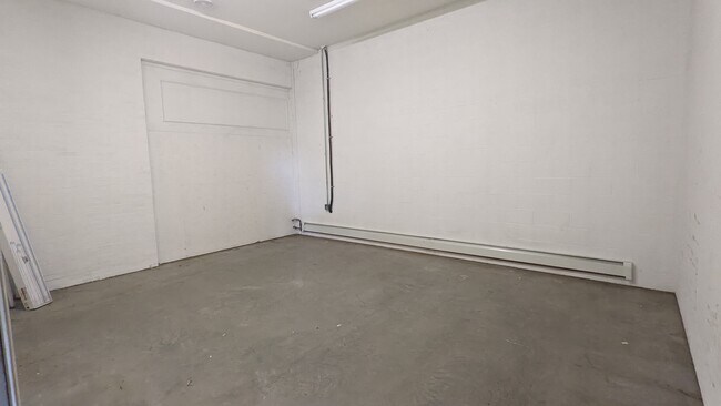
Officebuilding
Allegheny
X
Pennsylvania
42003C0302H
276
2024
1.24 AC
2025
West Pittsburgh
451300
Pittsburgh
DEMOGRAPHICS near 451 Mccormick Rd
1 mile
3 mile
5 mile
2024 Total Population
871
28,940
74,978
2029 Population
862
28,306
73,505
Pop Growth 2024-2029
(1.03%)
(2.19%)
(1.96%)
Average Age
44
42
42
2024 Total Households
342
12,304
31,100
HH Growth 2024-2029
(1.17%)
(2.30%)
(2.12%)
Median Household Inc
$172,222
$93,956
$92,010
Avg Household Size
2.50
2.30
2.30
2024 Avg HH Vehicles
2.00
2.00
2.00
Median Home Value
$469,148
$247,881
$264,225
Median Year Built
1995
1978
1975
Nearby Places
Map Layers
Map Styles
 Street
 Aerial
Transit
 Traffic
 Biking
Places
Listings with unknown addresses are not visible on the map
- Restaurants
- Banks
- Shops
- Fitness
- Groceries
PUBLIC TRANSPORTATION
AIRPORT
Pittsburgh International
Drive
Walk
Distance
Pittsburgh International
9 min
3.8 mi
SALE & LEASE HISTORY
LISTING DATE
SALE/LEASE

May 26, 2022
For Sale
Jul 30, 2020
For Lease
Nearby Properties
Address
Land Use
TOTAL SIZE
Lot Size
Zoning
Address
Land Use
TOTAL SIZE
Lot Size
Zoning
61.94 AC
Address
Land Use
TOTAL SIZE
Lot Size
Zoning
75.22 AC
Address
Land Use
TOTAL SIZE
Lot Size
Zoning
23.15 AC
Address
Land Use
TOTAL SIZE
Lot Size
Zoning
21.02 AC
Address
Land Use
TOTAL SIZE
Lot Size
Zoning
25.97 AC
Address
Land Use
TOTAL SIZE
Lot Size
Zoning
Address
Land Use
TOTAL SIZE
Lot Size
Zoning
16.97 AC
Address
Land Use
TOTAL SIZE
Lot Size
Zoning
2,274 SF
74.59 AC
Address
Land Use
TOTAL SIZE
Lot Size
Zoning
14.70 AC
Address
Land Use
TOTAL SIZE
Lot Size
Zoning
11.21 AC
Address
Land Use
TOTAL SIZE
Lot Size
Zoning
11.42 AC
Address
Land Use
TOTAL SIZE
Lot Size
Zoning
2.86 AC
Address
Land Use
TOTAL SIZE
Lot Size
Zoning
14.19 AC
Address
Land Use
TOTAL SIZE
Lot Size
Zoning
20.40 AC
Address
Land Use
TOTAL SIZE
Lot Size
Zoning
Address
Land Use
TOTAL SIZE
Lot Size
Zoning
Address
Land Use
TOTAL SIZE
Lot Size
Zoning
10.60 AC
Address
Land Use
TOTAL SIZE
Lot Size
Zoning
17.02 AC
Address
Land Use
TOTAL SIZE
Lot Size
Zoning
19.63 AC
Address
Land Use
TOTAL SIZE
Lot Size
Zoning
Address
Land Use
TOTAL SIZE
Lot Size
Zoning
3.30 AC
Address
Land Use
TOTAL SIZE
Lot Size
Zoning
Address
Land Use
TOTAL SIZE
Lot Size
Zoning
7.59 AC
Address
Land Use
TOTAL SIZE
Lot Size
Zoning
5.91 AC
Address
Land Use
TOTAL SIZE
Lot Size
Zoning
16.26 AC
Address
Land Use
TOTAL SIZE
Lot Size
Zoning
5.20 AC
Address
Land Use
TOTAL SIZE
Lot Size
Zoning
5.32 AC
Address
Land Use
TOTAL SIZE
Lot Size
Zoning
Address
Land Use
TOTAL SIZE
Lot Size
Zoning
Address
Land Use
TOTAL SIZE
Lot Size
Zoning
71.10 AC
The World's #1 Commercial Real Estate Marketplace
Connect with us
© 2026 CoStar Group
The information above has been obtained from sources believed reliable. While we do not doubt its accuracy we have not verified it and make no guarantee, warranty or representation about it. It is your responsibility to independently confirm its accuracy and completeness. Any projections, opinions, assumptions, or estimates used are for example only and do not represent the current or future performance of the property. The value of this transaction to you depends on tax and other factors which should be evaluated by your tax, financial, and legal advisors. You and your advisors should conduct a careful, independent investigation of the property to determine to your satisfaction the suitability of the property for your needs.