Property Record
4510 Ohara Ave, Brentwood, CA 94513
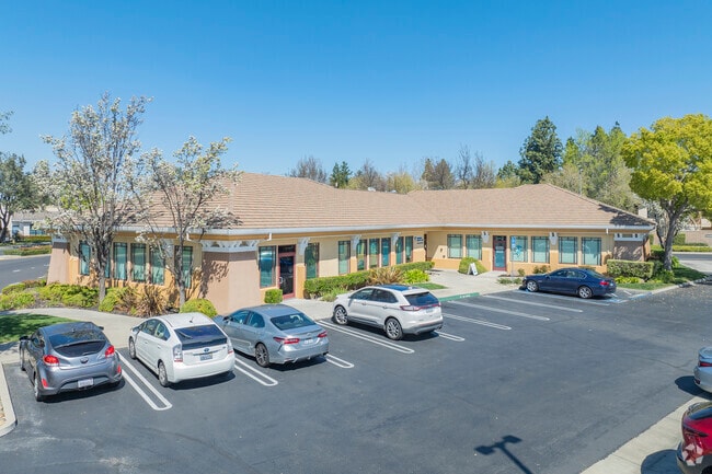


Property Detail
4510 Ohara Ave
013-010-089-4
T183PM6 PCL A
Officebuilding
CONTRA COSTA
B and X Area of moderate flood hazard, usually the area between the limits of the 100-year and 500-year floods.
California
2025
0.69 AC
2025
Antioch/Pittsburg
303105
East Bay/Oakland
9,926 SF
Oakland-Fremont-Berkeley, CA
NEARBY LISTINGS FOR SALE OR LEASE
DEMOGRAPHICS near 4510 Ohara Ave
1 mile
3 mile
5 mile
2025 Total Population
19,707
75,213
150,959
2030 Population
19,953
76,257
153,446
Pop Growth 2025-2030
+ 1.25%
+ 1.39%
+ 1.65%
Average Age
37
40
39
2025 Total Households
6,216
23,857
46,678
HH Growth 2025-2030
+ 1.29%
+ 1.45%
+ 1.70%
Median Household Inc
$125,325
$141,238
$136,257
Avg Household Size
3.10
3.10
3.20
2025 Avg HH Vehicles
2.00
2.00
2.00
Median Home Value
$750,832
$781,645
$753,712
Median Year Built
1999
2002
2000
Nearby Places
Map Layers
Map Styles
 Street
 Aerial
Layers
 Traffic
 Biking
Places
Listings with unknown addresses are not visible on the map
- Restaurants
- Banks
- Shops
- Fitness
- Groceries
PUBLIC TRANSPORTATION
AIRPORT
Stockton Metro
Drive
Walk
Distance
Stockton Metro
47 min
31.5 mi
Freight Ports
Port of Stockton
Drive
Walk
Distance
Port of Stockton
43 min
29.0 mi
SALE & LEASE HISTORY
LISTING DATE
SALE/LEASE

Oct 02, 2024
For Sale
Nearby Properties
Address
Land Use
TOTAL SIZE
Lot Size
Zoning
Address
Land Use
TOTAL SIZE
Lot Size
Zoning
39,038 SF
14.43 AC
Address
Land Use
TOTAL SIZE
Lot Size
Zoning
55.08 AC
Address
Land Use
TOTAL SIZE
Lot Size
Zoning
14,968 SF
7.07 AC
Address
Land Use
TOTAL SIZE
Lot Size
Zoning
129,450 SF
6.69 AC
Address
Land Use
TOTAL SIZE
Lot Size
Zoning
67,691 SF
28.26 AC
Address
Land Use
TOTAL SIZE
Lot Size
Zoning
67,133 SF
8.65 AC
Address
Land Use
TOTAL SIZE
Lot Size
Zoning
117,486 SF
7.26 AC
Address
Land Use
TOTAL SIZE
Lot Size
Zoning
15,000 SF
17.17 AC
Address
Land Use
TOTAL SIZE
Lot Size
Zoning
59,066 SF
3.89 AC
Address
Land Use
TOTAL SIZE
Lot Size
Zoning
113,902 SF
9.71 AC
Address
Land Use
TOTAL SIZE
Lot Size
Zoning
157,933 SF
19.04 AC
Address
Land Use
TOTAL SIZE
Lot Size
Zoning
141,367 SF
4.72 AC
Address
Land Use
TOTAL SIZE
Lot Size
Zoning
107,230 SF
1.54 AC
Address
Land Use
TOTAL SIZE
Lot Size
Zoning
12,410 SF
5.38 AC
Address
Land Use
TOTAL SIZE
Lot Size
Zoning
112,715 SF
4.48 AC
Address
Land Use
TOTAL SIZE
Lot Size
Zoning
51,980 SF
3.70 AC
Address
Land Use
TOTAL SIZE
Lot Size
Zoning
62,441 SF
5.65 AC
Address
Land Use
TOTAL SIZE
Lot Size
Zoning
13,468 SF
8.77 AC
Address
Land Use
TOTAL SIZE
Lot Size
Zoning
65,898 SF
8.72 AC
Address
Land Use
TOTAL SIZE
Lot Size
Zoning
23,822 SF
7.16 AC
Address
Land Use
TOTAL SIZE
Lot Size
Zoning
10.44 AC
Address
Land Use
TOTAL SIZE
Lot Size
Zoning
40,995 SF
10.59 AC
Address
Land Use
TOTAL SIZE
Lot Size
Zoning
96,956 SF
10.49 AC
Address
Land Use
TOTAL SIZE
Lot Size
Zoning
32,198 SF
1.08 AC
Address
Land Use
TOTAL SIZE
Lot Size
Zoning
141,267 SF
12.75 AC
Address
Land Use
TOTAL SIZE
Lot Size
Zoning
150,783 SF
5.79 AC
Address
Land Use
TOTAL SIZE
Lot Size
Zoning
47,642 SF
3.10 AC
Address
Land Use
TOTAL SIZE
Lot Size
Zoning
39,418 SF
3.08 AC
Address
Land Use
TOTAL SIZE
Lot Size
Zoning
36,915 SF
6.90 AC
Address
Land Use
TOTAL SIZE
Lot Size
Zoning
105,435 SF
11.90 AC
The World's #1 Commercial Real Estate Marketplace
Connect with us
© 2026 CoStar Group
The information above has been obtained from sources believed reliable. While we do not doubt its accuracy we have not verified it and make no guarantee, warranty or representation about it. It is your responsibility to independently confirm its accuracy and completeness. Any projections, opinions, assumptions, or estimates used are for example only and do not represent the current or future performance of the property. The value of this transaction to you depends on tax and other factors which should be evaluated by your tax, financial, and legal advisors. You and your advisors should conduct a careful, independent investigation of the property to determine to your satisfaction the suitability of the property for your needs.