Property Record
4513 Executive Dr, Naples, FL 34119
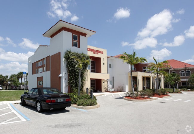


Property Detail
4513 Executive Dr
68815032250
QUAIL CREEK PLAZA PHASE II LOT 14 AND LOT 15; AND QUAIL CREEK PLAZA PH1, THAT PORTION OF TR B AS DESC IN OR 2239 PG 2249
Officebuilding
Collier
PUD
Florida
AH Areas with a 1% annual chance of shallow flooding, usually in the form of a pond, withan average depth ranging from 1 to 3 feet. These areas have a 26% chance of flooding over the life of a 30-year mortgage.
14
2024
2.70 AC
2025
North Naples
011207
Southwest Florida
39,600 SF
Naples-Marco Island, FL
NEARBY LISTINGS FOR SALE OR LEASE
DEMOGRAPHICS near 4513 Executive Dr
1 mile
3 mile
5 mile
2025 Total Population
5,417
54,661
119,966
2030 Population
5,822
58,612
130,138
Pop Growth 2025-2030
+ 7.48%
+ 7.23%
+ 8.48%
Average Age
52
48
50
2025 Total Households
2,552
22,948
52,021
HH Growth 2025-2030
+ 6.86%
+ 6.58%
+ 7.94%
Median Household Inc
$82,435
$100,092
$100,188
Avg Household Size
2.10
2.30
2.20
2025 Avg HH Vehicles
1.00
2.00
2.00
Median Home Value
$526,350
$708,061
$677,696
Median Year Built
2000
2002
2001
Nearby Places
Map Layers
Map Styles
 Street
 Aerial
Layers
 Traffic
 Biking
Places
Listings with unknown addresses are not visible on the map
- Restaurants
- Banks
- Shops
- Fitness
- Groceries
PUBLIC TRANSPORTATION
AIRPORT
Southwest Florida International
Drive
Walk
Distance
Southwest Florida International
30 min
23.4 mi
Freight Ports
Port Everglades
Drive
Walk
Distance
Port Everglades
123 min
110.4 mi
Nearby Properties
Address
Land Use
TOTAL SIZE
Lot Size
Zoning
Address
Land Use
TOTAL SIZE
Lot Size
Zoning
465,208 SF
17.72 AC
Address
Land Use
TOTAL SIZE
Lot Size
Zoning
325,993 SF
35.92 AC
A
Address
Land Use
TOTAL SIZE
Lot Size
Zoning
463,985 SF
28.48 AC
Address
Land Use
TOTAL SIZE
Lot Size
Zoning
312,140 SF
15 AC
Address
Land Use
TOTAL SIZE
Lot Size
Zoning
275,219 SF
16.20 AC
Address
Land Use
TOTAL SIZE
Lot Size
Zoning
110,908 SF
210.45 AC
A
Address
Land Use
TOTAL SIZE
Lot Size
Zoning
413,313 SF
48.48 AC
PUD
Address
Land Use
TOTAL SIZE
Lot Size
Zoning
376,493 SF
65.03 AC
RSF-3
Address
Land Use
TOTAL SIZE
Lot Size
Zoning
353,756 SF
23.26 AC
ROAD
Address
Land Use
TOTAL SIZE
Lot Size
Zoning
292,967 SF
13.12 AC
PUD
Address
Land Use
TOTAL SIZE
Lot Size
Zoning
426,074 SF
23.25 AC
PUD
Address
Land Use
TOTAL SIZE
Lot Size
Zoning
192,347 SF
7.84 AC
PUD
Address
Land Use
TOTAL SIZE
Lot Size
Zoning
174,365 SF
18.56 AC
PUD
Address
Land Use
TOTAL SIZE
Lot Size
Zoning
188,741 SF
9.04 AC
A
Address
Land Use
TOTAL SIZE
Lot Size
Zoning
128,681 SF
49.55 AC
A
Address
Land Use
TOTAL SIZE
Lot Size
Zoning
329,031 SF
20 AC
A
Address
Land Use
TOTAL SIZE
Lot Size
Zoning
142,737 SF
37.48 AC
A
Address
Land Use
TOTAL SIZE
Lot Size
Zoning
41,465 SF
3.36 AC
PUD
Address
Land Use
TOTAL SIZE
Lot Size
Zoning
106,929 SF
23.05 AC
A
Address
Land Use
TOTAL SIZE
Lot Size
Zoning
115,552 SF
13.20 AC
PUD
Address
Land Use
TOTAL SIZE
Lot Size
Zoning
104,317 SF
20 AC
PUD
Address
Land Use
TOTAL SIZE
Lot Size
Zoning
104,470 SF
13.06 AC
PUD
Address
Land Use
TOTAL SIZE
Lot Size
Zoning
22,099 SF
7.73 AC
PUD
Address
Land Use
TOTAL SIZE
Lot Size
Zoning
145,881 SF
142.48 AC
PUD
Address
Land Use
TOTAL SIZE
Lot Size
Zoning
86,254 SF
18.57 AC
A
Address
Land Use
TOTAL SIZE
Lot Size
Zoning
209,373 SF
23.76 AC
PUD
Address
Land Use
TOTAL SIZE
Lot Size
Zoning
52,370 SF
7.82 AC
PUD
Address
Land Use
TOTAL SIZE
Lot Size
Zoning
175,337 SF
14.61 AC
MPUD
Address
Land Use
TOTAL SIZE
Lot Size
Zoning
46,820 SF
7.02 AC
PUD
Address
Land Use
TOTAL SIZE
Lot Size
Zoning
75,307 SF
2.49 AC
The World's #1 Commercial Real Estate Marketplace
Connect with us
© 2026 CoStar Group
The information above has been obtained from sources believed reliable. While we do not doubt its accuracy we have not verified it and make no guarantee, warranty or representation about it. It is your responsibility to independently confirm its accuracy and completeness. Any projections, opinions, assumptions, or estimates used are for example only and do not represent the current or future performance of the property. The value of this transaction to you depends on tax and other factors which should be evaluated by your tax, financial, and legal advisors. You and your advisors should conduct a careful, independent investigation of the property to determine to your satisfaction the suitability of the property for your needs.