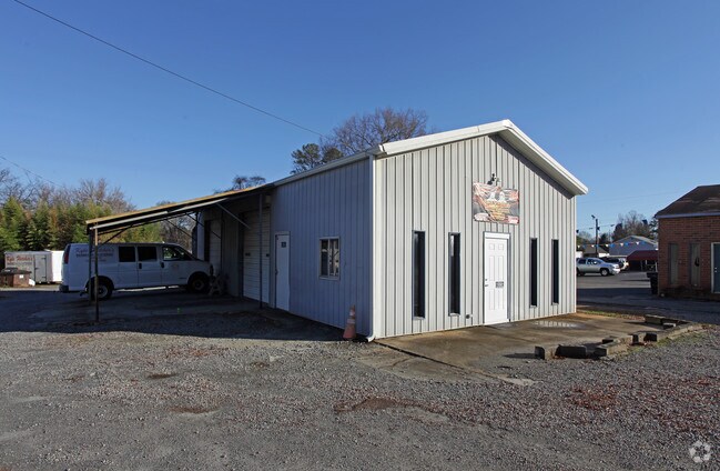
Property Record
4513 Wilkinson Blvd, Gastonia, NC 28056


NEARBY LISTINGS FOR SALE OR LEASE
Property Detail
4513 Wilkinson Blvd
128820
CORA LEE ROBINSON EST BLK 2 L 6 05 018 049 00 000
Financialbuilding
Gaston
X
North Carolina
3710357500J
0.36 AC
2025
Gaston County
2025
Charlotte
033303
Charlotte-Concord-Gastonia, NC-SC
1,104 SF
DEMOGRAPHICS near 4513 Wilkinson Blvd
1 Mile
3 Mile
5 Mile
2024 Total Population
4,494
40,932
107,672
2029 Population
4,789
43,762
115,085
Pop Growth 2024-2029
+ 6.56%
+ 6.91%
+ 6.88%
Average Age
41
40
40
2024 Total Households
2,003
16,680
43,837
HH Growth 2024-2029
+ 6.79%
+ 7.17%
+ 7.09%
Median Household Inc
$52,295
$65,157
$59,971
Avg Household Size
2.20
2.40
2.40
2024 Avg HH Vehicles
2.00
2.00
2.00
Median Home Value
$221,857
$223,250
$231,313
Median Year Built
1979
1985
1984
Nearby Places
Map Layers
Map Styles
 Street
 Aerial
- Restaurants
- Banks
- Shops
- Fitness
- Groceries
PUBLIC TRANSPORTATION
COMMUTER RAIL
DRIVE
WALK
Distance
9 min
5.0 mi
AIRPORT
Charlotte/Douglas International
DRIVE
WALK
Distance
Charlotte/Douglas International
26 min
12.8 mi
Concord-Padgett Regional
DRIVE
WALK
Distance
Concord-Padgett Regional
39 min
29.1 mi
Nearby Properties
Address
Land Use
TOTAL SIZE
Lot Size
Zoning
Address
Land Use
TOTAL SIZE
Lot Size
Zoning
104.72 AC
Address
Land Use
TOTAL SIZE
Lot Size
Zoning
1,886 SF
39.30 AC
Address
Land Use
TOTAL SIZE
Lot Size
Zoning
25,137 SF
34.81 AC
Address
Land Use
TOTAL SIZE
Lot Size
Zoning
54.70 AC
Address
Land Use
TOTAL SIZE
Lot Size
Zoning
43.38 AC
Address
Land Use
TOTAL SIZE
Lot Size
Zoning
47,625 SF
39.10 AC
SHOP2
Address
Land Use
TOTAL SIZE
Lot Size
Zoning
3,026 SF
32.14 AC
HCAR3
Address
Land Use
TOTAL SIZE
Lot Size
Zoning
30,906 SF
14.19 AC
Address
Land Use
TOTAL SIZE
Lot Size
Zoning
7,880 SF
18.35 AC
R1
Address
Land Use
TOTAL SIZE
Lot Size
Zoning
98.12 AC
Address
Land Use
TOTAL SIZE
Lot Size
Zoning
Address
Land Use
TOTAL SIZE
Lot Size
Zoning
28.04 AC
Address
Land Use
TOTAL SIZE
Lot Size
Zoning
30,000 SF
18.87 AC
SHOP2
Address
Land Use
TOTAL SIZE
Lot Size
Zoning
5,200 SF
22.98 AC
OFF01
Address
Land Use
TOTAL SIZE
Lot Size
Zoning
8,040 SF
18.44 AC
APT01
Address
Land Use
TOTAL SIZE
Lot Size
Zoning
3,120 SF
15.05 AC
OFF01
Address
Land Use
TOTAL SIZE
Lot Size
Zoning
8,960 SF
12.67 AC
Address
Land Use
TOTAL SIZE
Lot Size
Zoning
103,890 SF
8.81 AC
OFF04
Address
Land Use
TOTAL SIZE
Lot Size
Zoning
20.41 AC
Address
Land Use
TOTAL SIZE
Lot Size
Zoning
4,552 SF
9.22 AC
R1
Address
Land Use
TOTAL SIZE
Lot Size
Zoning
358,450 SF
23.50 AC
STOR2
Address
Land Use
TOTAL SIZE
Lot Size
Zoning
13,800 SF
58.55 AC
PUB01
Address
Land Use
TOTAL SIZE
Lot Size
Zoning
Address
Land Use
TOTAL SIZE
Lot Size
Zoning
1,868 SF
15.93 AC
OFF01
Address
Land Use
TOTAL SIZE
Lot Size
Zoning
5,120 SF
9.42 AC
Address
Land Use
TOTAL SIZE
Lot Size
Zoning
18,803 SF
9.57 AC
SHOP3
Address
Land Use
TOTAL SIZE
Lot Size
Zoning
33,258 SF
5.51 AC
Address
Land Use
TOTAL SIZE
Lot Size
Zoning
198,897 SF
10.89 AC
RET05
Address
Land Use
TOTAL SIZE
Lot Size
Zoning
6,774 SF
13.86 AC
APT02
Address
Land Use
TOTAL SIZE
Lot Size
Zoning
135,840 SF
11.21 AC
The World's #1 Commercial Real Estate Marketplace
Connect with us
© 2026 CoStar Group
The information above has been obtained from sources believed reliable. While we do not doubt its accuracy we have not verified it and make no guarantee, warranty or representation about it. It is your responsibility to independently confirm its accuracy and completeness. Any projections, opinions, assumptions, or estimates used are for example only and do not represent the current or future performance of the property. The value of this transaction to you depends on tax and other factors which should be evaluated by your tax, financial, and legal advisors. You and your advisors should conduct a careful, independent investigation of the property to determine to your satisfaction the suitability of the property for your needs.