Property Record
4512 Intelco Loop Se, Lacey, WA 98503
NEARBY LISTINGS FOR SALE OR LEASE
-
-
View all Lacey listings for sale on LoopNet.com
Property Detail
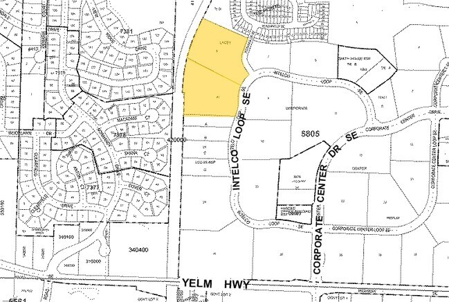
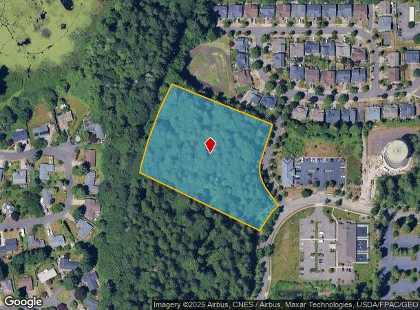
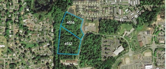
4512 Intelco Loop Se
Olympia-Lacey-Tumwater, WA
Lacey Corp Center-Replat
58050000800
SECTION 32 TOWNSHIP 18 RANGE 1W QUARTER SE PLAT LACEY CORP CENTER-REPLAT LT 8 DOCUMENT 024067 EX PTN TO CITY OF LACEY FOR R/W #3792908
Vacantlandnec
Thurston
X
Washington
53067C0189G
8
2024
4.22 AC
2025
Lacey
011626
Olympia
DEMOGRAPHICS near 4512 Intelco Loop Se
1 Mile
3 Mile
5 Mile
2024 Total Population
13,120
71,249
148,616
2029 Population
13,862
75,022
157,109
Pop Growth 2024-2029
+ 5.66%
+ 5.30%
+ 5.71%
Average Age
41
41
41
2024 Total Households
5,298
27,825
60,062
HH Growth 2024-2029
+ 5.85%
+ 5.41%
+ 5.87%
Median Household Inc
$75,791
$83,071
$78,321
Avg Household Size
2.40
2.50
2.40
2024 Avg HH Vehicles
2.00
2.00
2.00
Median Home Value
$384,965
$409,182
$400,445
Median Year Built
1996
1990
1988
Nearby Places
Map Layers
Map Styles
 Street
 Aerial
- Restaurants
- Banks
- Shops
- Fitness
- Groceries
SALE & LEASE HISTORY
LISTING DATE
SALE/LEASE

Dec 13, 2016
For Sale
Nearby Properties
Address
Land Use
TOTAL SIZE
Lot Size
Zoning
Address
Land Use
TOTAL SIZE
Lot Size
Zoning
771,482 SF
44.67 AC
MD
Address
Land Use
TOTAL SIZE
Lot Size
Zoning
171,420 SF
63.61 AC
SMU
Address
Land Use
TOTAL SIZE
Lot Size
Zoning
224,487 SF
14.36 AC
OSI-S
Address
Land Use
TOTAL SIZE
Lot Size
Zoning
206,496 SF
11.91 AC
RM-24
Address
Land Use
TOTAL SIZE
Lot Size
Zoning
357,949 SF
28.17 AC
WD
Address
Land Use
TOTAL SIZE
Lot Size
Zoning
221,642 SF
4.96 AC
CBD 5
Address
Land Use
TOTAL SIZE
Lot Size
Zoning
163,167 SF
8.20 AC
CBD 5
Address
Land Use
TOTAL SIZE
Lot Size
Zoning
185,762 SF
9.43 AC
CO
Address
Land Use
TOTAL SIZE
Lot Size
Zoning
273,214 SF
19.54 AC
WD
Address
Land Use
TOTAL SIZE
Lot Size
Zoning
123,338 SF
6.36 AC
RM-18
Address
Land Use
TOTAL SIZE
Lot Size
Zoning
192,392 SF
16.15 AC
MD
Address
Land Use
TOTAL SIZE
Lot Size
Zoning
223,442 SF
6.43 AC
CO
Address
Land Use
TOTAL SIZE
Lot Size
Zoning
168,325 SF
15.35 AC
HD
Address
Land Use
TOTAL SIZE
Lot Size
Zoning
161,068 SF
2.90 AC
Address
Land Use
TOTAL SIZE
Lot Size
Zoning
197,571 SF
52.35 AC
R-4-8
Address
Land Use
TOTAL SIZE
Lot Size
Zoning
79,184 SF
13.83 AC
OSI-S
Address
Land Use
TOTAL SIZE
Lot Size
Zoning
70,667 SF
156.27 AC
OS-I
Address
Land Use
TOTAL SIZE
Lot Size
Zoning
110,064 SF
3.47 AC
UV
Address
Land Use
TOTAL SIZE
Lot Size
Zoning
128,609 SF
9.49 AC
HD
Address
Land Use
TOTAL SIZE
Lot Size
Zoning
50,900 SF
16.62 AC
OSI-S
Address
Land Use
TOTAL SIZE
Lot Size
Zoning
48,988 SF
23.40 AC
SMU
Address
Land Use
TOTAL SIZE
Lot Size
Zoning
105,464 SF
3.06 AC
UV
Address
Land Use
TOTAL SIZE
Lot Size
Zoning
98,890 SF
2.06 AC
WD
Address
Land Use
TOTAL SIZE
Lot Size
Zoning
48,766 SF
15.22 AC
OSI-S
Address
Land Use
TOTAL SIZE
Lot Size
Zoning
54,960 SF
13.51 AC
OSI-S
Address
Land Use
TOTAL SIZE
Lot Size
Zoning
118,000 SF
11.86 AC
MD
Address
Land Use
TOTAL SIZE
Lot Size
Zoning
74,556 SF
3.17 AC
UV
Address
Land Use
TOTAL SIZE
Lot Size
Zoning
52,842 SF
2.90 AC
UV
Address
Land Use
TOTAL SIZE
Lot Size
Zoning
138,070 SF
15.85 AC
CCD
The World's #1 Commercial Real Estate Marketplace
Connect with us
© 2026 CoStar Group
The information above has been obtained from sources believed reliable. While we do not doubt its accuracy we have not verified it and make no guarantee, warranty or representation about it. It is your responsibility to independently confirm its accuracy and completeness. Any projections, opinions, assumptions, or estimates used are for example only and do not represent the current or future performance of the property. The value of this transaction to you depends on tax and other factors which should be evaluated by your tax, financial, and legal advisors. You and your advisors should conduct a careful, independent investigation of the property to determine to your satisfaction the suitability of the property for your needs.