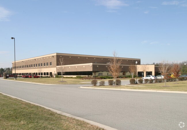
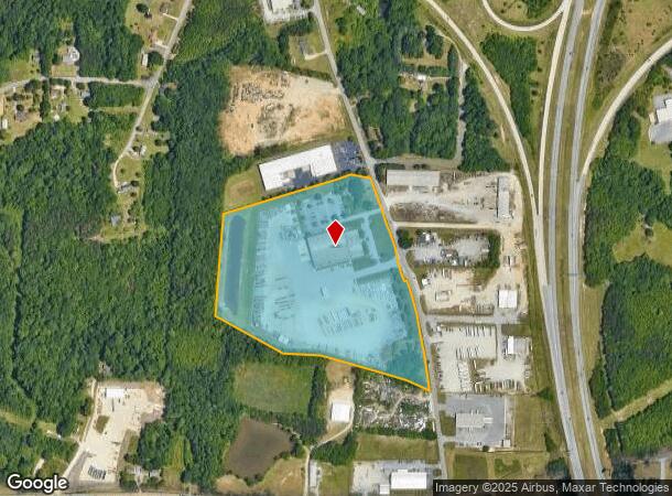
Property Record
4514 S Holden Rd, Greensboro, NC 27406
NEARBY LISTINGS FOR SALE OR LEASE
Property Detail
4514 S Holden Rd
Greensboro-High Point, NC
Land
0141878
GUY M TURNER, INC PLUS LAND LO:1
Industrialgeneral
Guilford
X
North Carolina
3710785100J
1
2024
22.68 AC
2025
Central Guilford County
012804
Greensboro/Winston-Salem
1,710 SF
DEMOGRAPHICS near 4514 S Holden Rd
1 Mile
3 Mile
5 Mile
2024 Total Population
1,899
36,961
104,154
2029 Population
1,878
36,671
103,825
Pop Growth 2024-2029
(1.11%)
(0.78%)
(0.32%)
Average Age
38
38
37
2024 Total Households
765
15,183
41,773
HH Growth 2024-2029
(1.05%)
(0.82%)
(0.27%)
Median Household Inc
$64,720
$52,112
$49,184
Avg Household Size
2.40
2.40
2.30
2024 Avg HH Vehicles
2.00
2.00
2.00
Median Home Value
$170,249
$145,220
$156,538
Median Year Built
1994
1984
1983
Nearby Places
Map Layers
Map Styles
 Street
 Aerial
- Restaurants
- Banks
- Shops
- Fitness
- Groceries
PUBLIC TRANSPORTATION
COMMUTER RAIL
Greensboro Station (Piedmont - North Carolina by Train (NC Train))
DRIVE
WALK
Distance
Greensboro Station (Piedmont - North Carolina by Train (NC Train))
10 min
6.5 mi
AIRPORT
Piedmont Triad International
DRIVE
WALK
Distance
Piedmont Triad International
21 min
12.0 mi
Freight Ports
Port of Wilmington
DRIVE
WALK
Distance
Port of Wilmington
246 min
214.1 mi
Nearby Properties
Address
Land Use
TOTAL SIZE
Lot Size
Zoning
Address
Land Use
TOTAL SIZE
Lot Size
Zoning
412,479 SF
19.68 AC
RM-26
Address
Land Use
TOTAL SIZE
Lot Size
Zoning
252,351 SF
9.48 AC
RM-18
Address
Land Use
TOTAL SIZE
Lot Size
Zoning
300,901 SF
20.39 AC
RM-18
Address
Land Use
TOTAL SIZE
Lot Size
Zoning
395,043 SF
15.74 AC
PUD
Address
Land Use
TOTAL SIZE
Lot Size
Zoning
182,499 SF
6.74 AC
O
Address
Land Use
TOTAL SIZE
Lot Size
Zoning
280,200 SF
19.28 AC
RM-12
Address
Land Use
TOTAL SIZE
Lot Size
Zoning
211,723 SF
20.24 AC
RM-18
Address
Land Use
TOTAL SIZE
Lot Size
Zoning
250,084 SF
5.46 AC
PI
Address
Land Use
TOTAL SIZE
Lot Size
Zoning
173,887 SF
12.46 AC
RM-18
Address
Land Use
TOTAL SIZE
Lot Size
Zoning
201,999 SF
22.18 AC
C-H
Address
Land Use
TOTAL SIZE
Lot Size
Zoning
188,976 SF
41.46 AC
R-5
Address
Land Use
TOTAL SIZE
Lot Size
Zoning
134,008 SF
10.48 AC
RM-18
Address
Land Use
TOTAL SIZE
Lot Size
Zoning
172,950 SF
11.49 AC
RM-18
Address
Land Use
TOTAL SIZE
Lot Size
Zoning
118,707 SF
15.94 AC
C-H
Address
Land Use
TOTAL SIZE
Lot Size
Zoning
107,867 SF
14.75 AC
RM-8
Address
Land Use
TOTAL SIZE
Lot Size
Zoning
111,810 SF
5.88 AC
O
Address
Land Use
TOTAL SIZE
Lot Size
Zoning
112,758 SF
10.96 AC
RM-12
Address
Land Use
TOTAL SIZE
Lot Size
Zoning
141,098 SF
8.59 AC
RM-18
Address
Land Use
TOTAL SIZE
Lot Size
Zoning
158,500 SF
17.35 AC
RM-12
Address
Land Use
TOTAL SIZE
Lot Size
Zoning
184,330 SF
10.92 AC
RM-12
Address
Land Use
TOTAL SIZE
Lot Size
Zoning
130,317 SF
11.81 AC
C-H
Address
Land Use
TOTAL SIZE
Lot Size
Zoning
92,927 SF
6.22 AC
RM-18
Address
Land Use
TOTAL SIZE
Lot Size
Zoning
146,677 SF
11.39 AC
LI
Address
Land Use
TOTAL SIZE
Lot Size
Zoning
95,304 SF
4.58 AC
RM-12
Address
Land Use
TOTAL SIZE
Lot Size
Zoning
117,356 SF
10.11 AC
RM-12
Address
Land Use
TOTAL SIZE
Lot Size
Zoning
303,738 SF
2.41 AC
C-H
Address
Land Use
TOTAL SIZE
Lot Size
Zoning
185,278 SF
20 AC
LI
Address
Land Use
TOTAL SIZE
Lot Size
Zoning
177,850 SF
93.40 AC
AG
Address
Land Use
TOTAL SIZE
Lot Size
Zoning
451,367 SF
50.59 AC
LI
Address
Land Use
TOTAL SIZE
Lot Size
Zoning
152,820 SF
9 AC
RM-12
The World's #1 Commercial Real Estate Marketplace
Connect with us
© 2026 CoStar Group
The information above has been obtained from sources believed reliable. While we do not doubt its accuracy we have not verified it and make no guarantee, warranty or representation about it. It is your responsibility to independently confirm its accuracy and completeness. Any projections, opinions, assumptions, or estimates used are for example only and do not represent the current or future performance of the property. The value of this transaction to you depends on tax and other factors which should be evaluated by your tax, financial, and legal advisors. You and your advisors should conduct a careful, independent investigation of the property to determine to your satisfaction the suitability of the property for your needs.