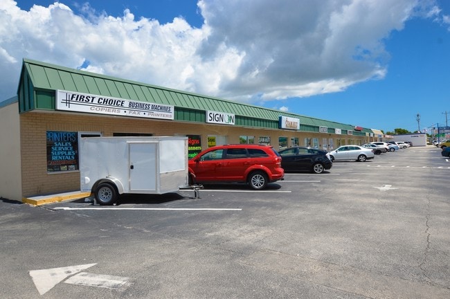
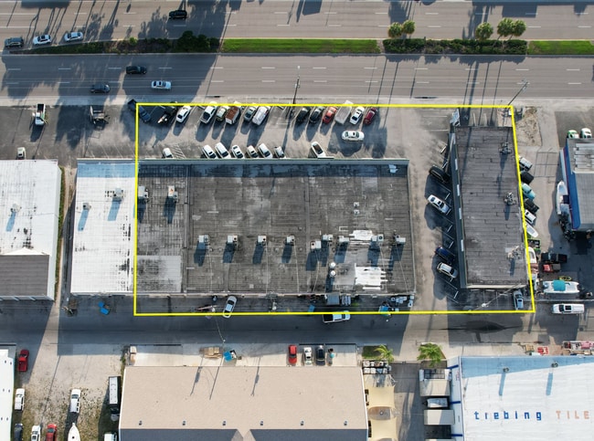
Property Record
4519 Del Prado Blvd S, Cape Coral, FL 33904
Current Lease Availabilities
NEARBY LISTINGS FOR SALE OR LEASE
Property Detail
4519 Del Prado Blvd S
Cape Coral-Fort Myers, FL
Cape Coral
07-45-24-C3-00396.0240
CAPE CORAL UNIT 7 BLK 396 PB 12 PG 120 LOTS 24 THRU 27 + PORTIONS OF LOTS 28 + 29
Regionalshoppingcenterormallwithanchorstore
Lee
AE
Florida
12071C0404G
24-28
2024
0.76 AC
2025
Cape Coral
010702
Southwest Florida
20,266 SF
DEMOGRAPHICS near 4519 Del Prado Blvd S
1 Mile
3 Mile
5 Mile
2024 Total Population
8,348
62,356
190,835
2029 Population
10,030
73,999
226,322
Pop Growth 2024-2029
+ 20.15%
+ 18.67%
+ 18.60%
Average Age
53
50
48
2024 Total Households
4,352
29,127
85,830
HH Growth 2024-2029
+ 19.78%
+ 18.35%
+ 18.31%
Median Household Inc
$54,661
$62,389
$62,102
Avg Household Size
1.90
2.10
2.10
2024 Avg HH Vehicles
2.00
2.00
2.00
Median Home Value
$316,493
$309,758
$287,105
Median Year Built
1981
1984
1988
Nearby Places
- Restaurants
- Banks
- Shops
- Fitness
- Groceries
PUBLIC TRANSPORTATION
AIRPORT
Southwest Florida International
DRIVE
WALK
Distance
Southwest Florida International
26 min
13.8 mi
Punta Gorda
DRIVE
WALK
Distance
Punta Gorda
46 min
29.0 mi
Freight Ports
Port Manatee
DRIVE
WALK
Distance
Port Manatee
126 min
100.7 mi
Nearby Properties
Address
Land Use
TOTAL SIZE
Lot Size
Zoning
Address
Land Use
TOTAL SIZE
Lot Size
Zoning
423,044 SF
37.11 AC
C-1
Address
Land Use
TOTAL SIZE
Lot Size
Zoning
381,135 SF
15.07 AC
MPD
Address
Land Use
TOTAL SIZE
Lot Size
Zoning
1,446 SF
9.81 AC
RS-6
Address
Land Use
TOTAL SIZE
Lot Size
Zoning
211,588 SF
14.89 AC
MPD
Address
Land Use
TOTAL SIZE
Lot Size
Zoning
144,607 SF
20 AC
INS
Address
Land Use
TOTAL SIZE
Lot Size
Zoning
54,248 SF
15.42 AC
C1-W
Address
Land Use
TOTAL SIZE
Lot Size
Zoning
99,749 SF
11.49 AC
WSHP
Address
Land Use
TOTAL SIZE
Lot Size
Zoning
66,486 SF
0.56 AC
C-1A
Address
Land Use
TOTAL SIZE
Lot Size
Zoning
113,239 SF
12.62 AC
R1-D
Address
Land Use
TOTAL SIZE
Lot Size
Zoning
26,337 SF
11.54 AC
C-1
Address
Land Use
TOTAL SIZE
Lot Size
Zoning
47,660 SF
3.52 AC
C1-D
Address
Land Use
TOTAL SIZE
Lot Size
Zoning
95,942 SF
5.22 AC
C1-D
Address
Land Use
TOTAL SIZE
Lot Size
Zoning
121,182 SF
9.91 AC
C-1A
Address
Land Use
TOTAL SIZE
Lot Size
Zoning
52,003 SF
6.66 AC
WSHP
Address
Land Use
TOTAL SIZE
Lot Size
Zoning
69,261 SF
8.44 AC
WSHP
Address
Land Use
TOTAL SIZE
Lot Size
Zoning
81,988 SF
7.97 AC
C-1A
Address
Land Use
TOTAL SIZE
Lot Size
Zoning
87,627 SF
8.75 AC
C-1A
Address
Land Use
TOTAL SIZE
Lot Size
Zoning
74,368 SF
2.32 AC
SC
Address
Land Use
TOTAL SIZE
Lot Size
Zoning
65,875 SF
7.67 AC
MPD
Address
Land Use
TOTAL SIZE
Lot Size
Zoning
86,497 SF
6.20 AC
SC
Address
Land Use
TOTAL SIZE
Lot Size
Zoning
45,809 SF
1.75 AC
SC
Address
Land Use
TOTAL SIZE
Lot Size
Zoning
77,465 SF
5.39 AC
CPD
Address
Land Use
TOTAL SIZE
Lot Size
Zoning
82,526 SF
113.48 AC
PUD
Address
Land Use
TOTAL SIZE
Lot Size
Zoning
67,396 SF
2.02 AC
SC
Address
Land Use
TOTAL SIZE
Lot Size
Zoning
76,025 SF
2.25 AC
MPD
Address
Land Use
TOTAL SIZE
Lot Size
Zoning
1,098 SF
3.58 AC
RS-1
Address
Land Use
TOTAL SIZE
Lot Size
Zoning
39,441 SF
3.05 AC
C-1
Address
Land Use
TOTAL SIZE
Lot Size
Zoning
46,386 SF
3.43 AC
C-1
Address
Land Use
TOTAL SIZE
Lot Size
Zoning
23,799 SF
2.27 AC
RS-1
Address
Land Use
TOTAL SIZE
Lot Size
Zoning
97,049 SF
1.05 AC
C-1
The World's #1 Commercial Real Estate Marketplace
Connect with us
© 2025 CoStar Group
The information above has been obtained from sources believed reliable. While we do not doubt its accuracy we have not verified it and make no guarantee, warranty or representation about it. It is your responsibility to independently confirm its accuracy and completeness. Any projections, opinions, assumptions, or estimates used are for example only and do not represent the current or future performance of the property. The value of this transaction to you depends on tax and other factors which should be evaluated by your tax, financial, and legal advisors. You and your advisors should conduct a careful, independent investigation of the property to determine to your satisfaction the suitability of the property for your needs.