Property Record
4521 Beaty Rd, Gastonia, NC 28056
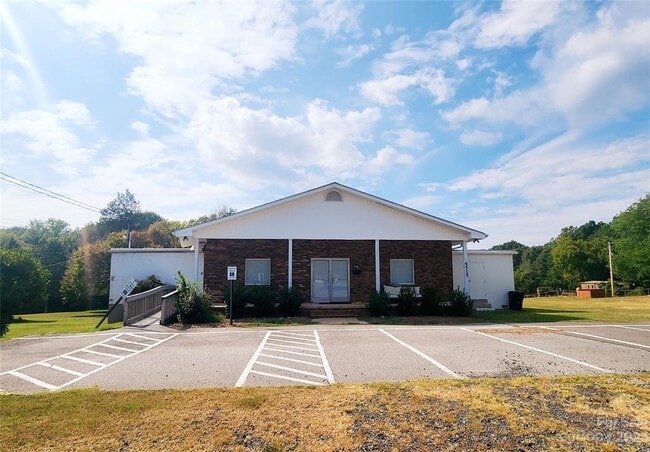


This Property Is For Sale
Property Detail
4521 Beaty Rd
Charlotte-Concord-Gastonia, NC-SC
BEATY RD. TRACT 2 PLAT BOOK 096 PAGE 050
308261
Gaston
Financialbuilding
North Carolina
2025
1.68 AC
2025
Gaston County
033312
Charlotte
840 SF
NEARBY LISTINGS FOR SALE OR LEASE
-
-
View all Gastonia listings for sale on LoopNet.com
DEMOGRAPHICS near 4521 Beaty Rd
1 mile
3 mile
5 mile
2025 Total Population
2,272
22,918
69,871
2030 Population
2,408
24,227
73,529
Pop Growth 2025-2030
+ 5.99%
+ 5.71%
+ 5.24%
Average Age
40
42
41
2025 Total Households
817
8,776
27,723
HH Growth 2025-2030
+ 6.24%
+ 5.95%
+ 5.37%
Median Household Inc
$110,019
$108,532
$80,437
Avg Household Size
2.70
2.60
2.40
2025 Avg HH Vehicles
3.00
2.00
2.00
Median Home Value
$352,573
$377,904
$337,009
Median Year Built
1993
1992
1988
Nearby Places
Map Layers
Map Styles
 Street
 Aerial
Layers
 Traffic
 Biking
Places
Listings with unknown addresses are not visible on the map
- Restaurants
- Banks
- Shops
- Fitness
- Groceries
PUBLIC TRANSPORTATION
AIRPORT
Charlotte/Douglas International
Drive
Walk
Distance
Charlotte/Douglas International
35 min
16.4 mi
Concord-Padgett Regional
Drive
Walk
Distance
Concord-Padgett Regional
48 min
33.5 mi
Nearby Properties
Address
Land Use
TOTAL SIZE
Lot Size
Zoning
Address
Land Use
TOTAL SIZE
Lot Size
Zoning
1,886 SF
13.27 AC
APT01
Address
Land Use
TOTAL SIZE
Lot Size
Zoning
203,152 SF
67.60 AC
PUB01
Address
Land Use
TOTAL SIZE
Lot Size
Zoning
1,170 SF
320.29 AC
OFF01
Address
Land Use
TOTAL SIZE
Lot Size
Zoning
6,774 SF
13.86 AC
APT02
Address
Land Use
TOTAL SIZE
Lot Size
Zoning
7,949 SF
7.95 AC
SHOP1
Address
Land Use
TOTAL SIZE
Lot Size
Zoning
5,604 SF
56.06 AC
PUB01
Address
Land Use
TOTAL SIZE
Lot Size
Zoning
6,608 SF
9.10 AC
Address
Land Use
TOTAL SIZE
Lot Size
Zoning
5,432 SF
7.61 AC
APT02
Address
Land Use
TOTAL SIZE
Lot Size
Zoning
98,868 SF
3.30 AC
Address
Land Use
TOTAL SIZE
Lot Size
Zoning
Address
Land Use
TOTAL SIZE
Lot Size
Zoning
15,000 SF
34.49 AC
PUB01
Address
Land Use
TOTAL SIZE
Lot Size
Zoning
19,653 SF
2.31 AC
R1
Address
Land Use
TOTAL SIZE
Lot Size
Zoning
63,000 SF
4.95 AC
PUB01
Address
Land Use
TOTAL SIZE
Lot Size
Zoning
8,874 SF
24.89 AC
PUB01
Address
Land Use
TOTAL SIZE
Lot Size
Zoning
73,722 SF
8.93 AC
HCAR4
Address
Land Use
TOTAL SIZE
Lot Size
Zoning
113.75 AC
Address
Land Use
TOTAL SIZE
Lot Size
Zoning
35,143 SF
7.95 AC
SP02
Address
Land Use
TOTAL SIZE
Lot Size
Zoning
9,792 SF
3.77 AC
Address
Land Use
TOTAL SIZE
Lot Size
Zoning
5,850 SF
4.47 AC
Address
Land Use
TOTAL SIZE
Lot Size
Zoning
2,715 SF
11.65 AC
Address
Land Use
TOTAL SIZE
Lot Size
Zoning
65,545 SF
9.81 AC
SHOP1
Address
Land Use
TOTAL SIZE
Lot Size
Zoning
7,560 SF
189.75 AC
STOR5
Address
Land Use
TOTAL SIZE
Lot Size
Zoning
16,728 SF
2.41 AC
Address
Land Use
TOTAL SIZE
Lot Size
Zoning
20,290 SF
3.12 AC
Address
Land Use
TOTAL SIZE
Lot Size
Zoning
9,000 SF
5.26 AC
SHOP1
Address
Land Use
TOTAL SIZE
Lot Size
Zoning
26,060 SF
15.66 AC
CHUR2
Address
Land Use
TOTAL SIZE
Lot Size
Zoning
8,352 SF
2.92 AC
APT01
Address
Land Use
TOTAL SIZE
Lot Size
Zoning
13,507 SF
1.29 AC
RET05
Address
Land Use
TOTAL SIZE
Lot Size
Zoning
10,118 SF
1.53 AC
Address
Land Use
TOTAL SIZE
Lot Size
Zoning
2,015 SF
13.38 AC
R1
The World's #1 Commercial Real Estate Marketplace
Connect with us
© 2026 CoStar Group
The information above has been obtained from sources believed reliable. While we do not doubt its accuracy we have not verified it and make no guarantee, warranty or representation about it. It is your responsibility to independently confirm its accuracy and completeness. Any projections, opinions, assumptions, or estimates used are for example only and do not represent the current or future performance of the property. The value of this transaction to you depends on tax and other factors which should be evaluated by your tax, financial, and legal advisors. You and your advisors should conduct a careful, independent investigation of the property to determine to your satisfaction the suitability of the property for your needs.