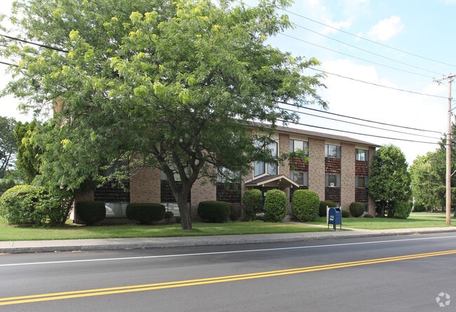
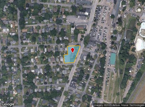
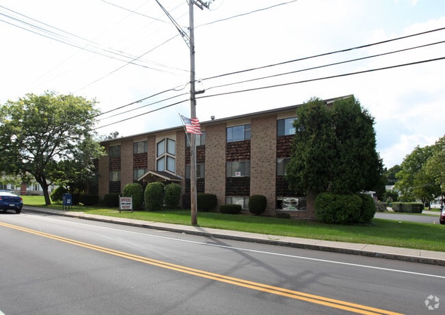
Property Record
4515 Culver Rd, Rochester, NY 14622
NEARBY LISTINGS FOR SALE OR LEASE
Property Detail
4515 Culver Rd
Rochester, NY
Crouch Farm Subdivision Amended
263400-062-150-0005-012-000
0005-14-07 CROUCH FARM LR145 01
Officebuilding
Monroe
X
New York
36055C0206H
12.000
2025
0.68 AC
2024
Northeast
010700
Rochester
6,000 SF
DEMOGRAPHICS near 4515 Culver Rd
1 Mile
3 Mile
5 Mile
2024 Total Population
3,991
37,269
157,658
2029 Population
3,944
36,794
155,247
Pop Growth 2024-2029
(1.18%)
(1.27%)
(1.53%)
Average Age
45
44
41
2024 Total Households
1,896
16,113
67,460
HH Growth 2024-2029
(1.27%)
(1.33%)
(1.59%)
Median Household Inc
$62,048
$73,808
$58,706
Avg Household Size
2.10
2.30
2.30
2024 Avg HH Vehicles
2.00
2.00
2.00
Median Home Value
$144,554
$169,152
$150,286
Median Year Built
1949
1956
1955
Nearby Places
- Restaurants
- Banks
- Shops
- Fitness
- Groceries
PUBLIC TRANSPORTATION
COMMUTER RAIL
Rochester (Empire Service - VIA Rail, Lake Shore Limited - VIA Rail, Maple Leaf - VIA Rail, Toronto - New York - VIA Rail)
DRIVE
WALK
Distance
Rochester (Empire Service - VIA Rail, Lake Shore Limited - VIA Rail, Maple Leaf - VIA Rail, Toronto - New York - VIA Rail)
11 min
6.4 mi
AIRPORT
Frederick Douglass/Greater Rochester International
DRIVE
WALK
Distance
Frederick Douglass/Greater Rochester International
20 min
11.6 mi
Freight Ports
Albany, NY Port
DRIVE
WALK
Distance
Albany, NY Port
270 min
229.2 mi
Nearby Properties
Address
Land Use
TOTAL SIZE
Lot Size
Zoning
Address
Land Use
TOTAL SIZE
Lot Size
Zoning
270,150 SF
34.40 AC
02 - SINGL
Address
Land Use
TOTAL SIZE
Lot Size
Zoning
323,264 SF
21.06 AC
06 - INDUS
Address
Land Use
TOTAL SIZE
Lot Size
Zoning
161,812 SF
5.18 AC
06 - INDUS
Address
Land Use
TOTAL SIZE
Lot Size
Zoning
193,892 SF
18.62 AC
05 - COMME
Address
Land Use
TOTAL SIZE
Lot Size
Zoning
48,000 SF
19.51 AC
03 - MULTI
Address
Land Use
TOTAL SIZE
Lot Size
Zoning
224,048 SF
37.60 AC
02 - SINGL
Address
Land Use
TOTAL SIZE
Lot Size
Zoning
134,894 SF
16 AC
01 - NOT Z
Address
Land Use
TOTAL SIZE
Lot Size
Zoning
73,724 SF
11.79 AC
02 - SINGL
Address
Land Use
TOTAL SIZE
Lot Size
Zoning
124,000 SF
8.99 AC
06 - INDUS
Address
Land Use
TOTAL SIZE
Lot Size
Zoning
930 SF
13.45 AC
03 - MULTI
Address
Land Use
TOTAL SIZE
Lot Size
Zoning
Address
Land Use
TOTAL SIZE
Lot Size
Zoning
8,464 SF
9.60 AC
03 - MULTI
Address
Land Use
TOTAL SIZE
Lot Size
Zoning
74,335 SF
5.13 AC
06 - INDUS
Address
Land Use
TOTAL SIZE
Lot Size
Zoning
22,308 SF
34.40 AC
02 - SINGL
Address
Land Use
TOTAL SIZE
Lot Size
Zoning
Address
Land Use
TOTAL SIZE
Lot Size
Zoning
0.67 AC
06 - INDUS
Address
Land Use
TOTAL SIZE
Lot Size
Zoning
7,440 SF
9.69 AC
03 - MULTI
Address
Land Use
TOTAL SIZE
Lot Size
Zoning
145,335 SF
42 AC
02 - SINGL
Address
Land Use
TOTAL SIZE
Lot Size
Zoning
52,648 SF
13.59 AC
02 - SINGL
Address
Land Use
TOTAL SIZE
Lot Size
Zoning
200 SF
105.92 AC
Address
Land Use
TOTAL SIZE
Lot Size
Zoning
11,600 SF
3.76 AC
02 - SINGL
Address
Land Use
TOTAL SIZE
Lot Size
Zoning
Address
Land Use
TOTAL SIZE
Lot Size
Zoning
6,630 SF
9.50 AC
06 - INDUS
Address
Land Use
TOTAL SIZE
Lot Size
Zoning
74,866 SF
4.40 AC
05 - COMME
Address
Land Use
TOTAL SIZE
Lot Size
Zoning
14,642 SF
1.44 AC
05 - COMME
Address
Land Use
TOTAL SIZE
Lot Size
Zoning
62,087 SF
4.70 AC
02 - SINGL
Address
Land Use
TOTAL SIZE
Lot Size
Zoning
2,483 SF
13.68 AC
Address
Land Use
TOTAL SIZE
Lot Size
Zoning
4,575 SF
620.50 AC
Address
Land Use
TOTAL SIZE
Lot Size
Zoning
75,904 SF
6.74 AC
02 - SINGL
Address
Land Use
TOTAL SIZE
Lot Size
Zoning
10,094 SF
7.70 AC
02 - SINGL
The World's #1 Commercial Real Estate Marketplace
Connect with us
© 2025 CoStar Group
The information above has been obtained from sources believed reliable. While we do not doubt its accuracy we have not verified it and make no guarantee, warranty or representation about it. It is your responsibility to independently confirm its accuracy and completeness. Any projections, opinions, assumptions, or estimates used are for example only and do not represent the current or future performance of the property. The value of this transaction to you depends on tax and other factors which should be evaluated by your tax, financial, and legal advisors. You and your advisors should conduct a careful, independent investigation of the property to determine to your satisfaction the suitability of the property for your needs.