Property Record
4515 Fleur Dr, Des Moines, IA 50321
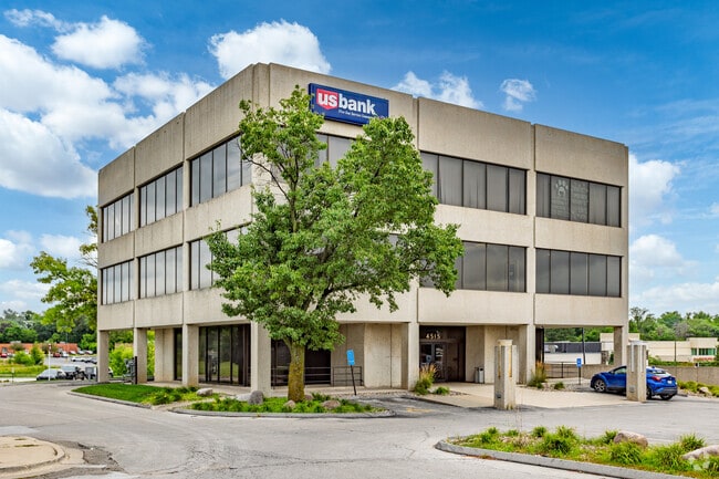

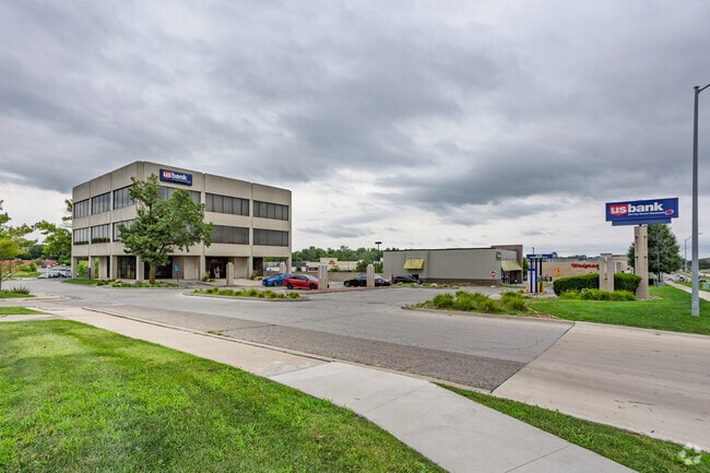
This Property Is For Sale
Property Detail
4515 Fleur Dr
120-07109001001
-EX ST- S148.59F N322.2F W 451F SW 1/4 SE 1/4 SEC 20-78-24
Financialbuilding
Polk
C-2
Iowa
B and X Area of moderate flood hazard, usually the area between the limits of the 100-year and 500-year floods.
1.40 AC
2024
South
2025
Des Moines
004502
Des Moines-West Des Moines, IA
15,090 SF
NEARBY LISTINGS FOR SALE OR LEASE
DEMOGRAPHICS near 4515 Fleur Dr
1 mile
3 mile
5 mile
2025 Total Population
7,952
60,100
162,880
2030 Population
8,196
62,777
170,841
Pop Growth 2025-2030
+ 3.07%
+ 4.45%
+ 4.89%
Average Age
42
38
37
2025 Total Households
3,467
26,071
68,656
HH Growth 2025-2030
+ 3.32%
+ 4.98%
+ 5.21%
Median Household Inc
$80,491
$64,350
$63,074
Avg Household Size
2.20
2.20
2.20
2025 Avg HH Vehicles
2.00
2.00
2.00
Median Home Value
$231,589
$189,382
$219,792
Median Year Built
1962
1970
1971
Nearby Places
Map Layers
Map Styles
 Street
 Aerial
Layers
 Traffic
 Biking
Places
Listings with unknown addresses are not visible on the map
- Restaurants
- Banks
- Shops
- Fitness
- Groceries
PUBLIC TRANSPORTATION
AIRPORT
Des Moines International
Drive
Walk
Distance
Des Moines International
5 min
1.5 mi
Nearby Properties
Address
Land Use
TOTAL SIZE
Lot Size
Zoning
Address
Land Use
TOTAL SIZE
Lot Size
Zoning
594,010 SF
24.40 AC
R1-80
Address
Land Use
TOTAL SIZE
Lot Size
Zoning
839,211 SF
4.93 AC
C-3A
Address
Land Use
TOTAL SIZE
Lot Size
Zoning
260,284 SF
2.98 AC
Address
Land Use
TOTAL SIZE
Lot Size
Zoning
289,527 SF
11.23 AC
PUD
Address
Land Use
TOTAL SIZE
Lot Size
Zoning
798,696 SF
4.04 AC
C-3
Address
Land Use
TOTAL SIZE
Lot Size
Zoning
397,938 SF
27.97 AC
PUD
Address
Land Use
TOTAL SIZE
Lot Size
Zoning
335,556 SF
0.86 AC
C-3
Address
Land Use
TOTAL SIZE
Lot Size
Zoning
244,212 SF
2.20 AC
NPC
Address
Land Use
TOTAL SIZE
Lot Size
Zoning
432,630 SF
0.82 AC
C-3
Address
Land Use
TOTAL SIZE
Lot Size
Zoning
302,800 SF
20.85 AC
Address
Land Use
TOTAL SIZE
Lot Size
Zoning
178,611 SF
3.02 AC
Address
Land Use
TOTAL SIZE
Lot Size
Zoning
427,768 SF
0.87 AC
C-3
Address
Land Use
TOTAL SIZE
Lot Size
Zoning
203,710 SF
26.88 AC
Address
Land Use
TOTAL SIZE
Lot Size
Zoning
117,000 SF
4.02 AC
PUD
Address
Land Use
TOTAL SIZE
Lot Size
Zoning
184,659 SF
4.10 AC
Address
Land Use
TOTAL SIZE
Lot Size
Zoning
298,716 SF
18.90 AC
PUD
Address
Land Use
TOTAL SIZE
Lot Size
Zoning
162,217 SF
6.32 AC
Address
Land Use
TOTAL SIZE
Lot Size
Zoning
336,394 SF
2.19 AC
C-3A
Address
Land Use
TOTAL SIZE
Lot Size
Zoning
526,295 SF
26.06 AC
M-1
Address
Land Use
TOTAL SIZE
Lot Size
Zoning
1,070,647 SF
2.96 AC
C-3
Address
Land Use
TOTAL SIZE
Lot Size
Zoning
298,528 SF
3.79 AC
R-4
Address
Land Use
TOTAL SIZE
Lot Size
Zoning
274,385 SF
3.83 AC
D-R
Address
Land Use
TOTAL SIZE
Lot Size
Zoning
96,032 SF
1.74 AC
Address
Land Use
TOTAL SIZE
Lot Size
Zoning
208,456 SF
14.42 AC
PUD
Address
Land Use
TOTAL SIZE
Lot Size
Zoning
231,168 SF
22.29 AC
PUD
Address
Land Use
TOTAL SIZE
Lot Size
Zoning
161,788 SF
9.41 AC
PBP
Address
Land Use
TOTAL SIZE
Lot Size
Zoning
61,320 SF
8.13 AC
Address
Land Use
TOTAL SIZE
Lot Size
Zoning
104,749 SF
0.51 AC
Address
Land Use
TOTAL SIZE
Lot Size
Zoning
237,306 SF
0.82 AC
The World's #1 Commercial Real Estate Marketplace
Connect with us
© 2026 CoStar Group
The information above has been obtained from sources believed reliable. While we do not doubt its accuracy we have not verified it and make no guarantee, warranty or representation about it. It is your responsibility to independently confirm its accuracy and completeness. Any projections, opinions, assumptions, or estimates used are for example only and do not represent the current or future performance of the property. The value of this transaction to you depends on tax and other factors which should be evaluated by your tax, financial, and legal advisors. You and your advisors should conduct a careful, independent investigation of the property to determine to your satisfaction the suitability of the property for your needs.