Property Record
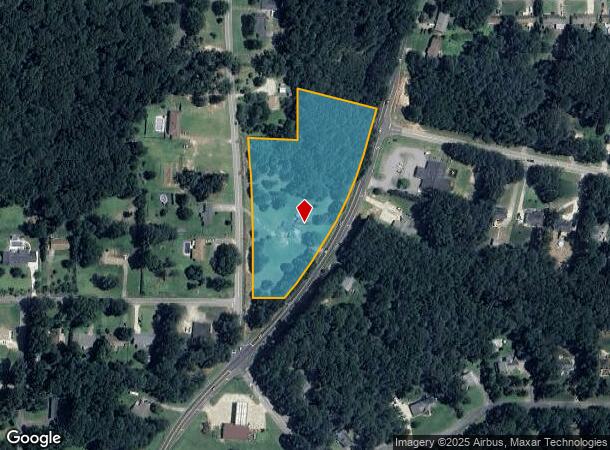
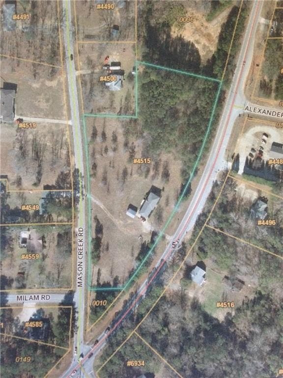
4515 Highway 5, Douglasville, GA 30135

This Property Is For Sale
NEARBY LISTINGS FOR SALE OR LEASE
-
-
View all Douglasville listings for sale on LoopNet.com
Property Detail
4515 Highway 5
Atlanta-Sandy Springs-Roswell, GA
Mason Creek
9025-00-6-0-005
HSE/4.023 AC, GA HWY 5 @ MASON CREEK RD
Commercialnec
Douglas
X
Georgia
13097C0141D
69
2024
4.02 AC
2024
Villa Rica/West Outlying
080506
Atlanta
2,000 SF
DEMOGRAPHICS near 4515 Highway 5
1 Mile
3 Mile
5 Mile
2024 Total Population
2,779
20,521
45,983
2029 Population
2,926
21,626
48,464
Pop Growth 2024-2029
+ 5.29%
+ 5.38%
+ 5.40%
Average Age
40
40
39
2024 Total Households
938
7,062
16,132
HH Growth 2024-2029
+ 5.54%
+ 5.51%
+ 5.47%
Median Household Inc
$67,101
$67,506
$69,688
Avg Household Size
2.90
2.80
2.80
2024 Avg HH Vehicles
2.00
2.00
2.00
Median Home Value
$196,503
$195,680
$234,532
Median Year Built
1978
1983
1989
Nearby Places
- Restaurants
- Banks
- Shops
- Fitness
- Groceries
PUBLIC TRANSPORTATION
AIRPORT
Hartsfield - Jackson Atlanta International
DRIVE
WALK
Distance
Hartsfield - Jackson Atlanta International
48 min
35.7 mi
Freight Ports
Georgia Ports - Savannah
DRIVE
WALK
Distance
Georgia Ports - Savannah
311 min
275.0 mi
Nearby Properties
Address
Land Use
TOTAL SIZE
Lot Size
Zoning
Address
Land Use
TOTAL SIZE
Lot Size
Zoning
166,816 SF
26.23 AC
R-MF
Address
Land Use
TOTAL SIZE
Lot Size
Zoning
3,500 SF
51.89 AC
DCD
Address
Land Use
TOTAL SIZE
Lot Size
Zoning
46,996 SF
25.77 AC
R-LD
Address
Land Use
TOTAL SIZE
Lot Size
Zoning
71,186 SF
10.15 AC
C-G
Address
Land Use
TOTAL SIZE
Lot Size
Zoning
30,850 SF
2.79 AC
C-G
Address
Land Use
TOTAL SIZE
Lot Size
Zoning
10,898 SF
10.91 AC
R-A
Address
Land Use
TOTAL SIZE
Lot Size
Zoning
13,416 SF
2.19 AC
Address
Land Use
TOTAL SIZE
Lot Size
Zoning
4,968 SF
1.50 AC
B-COMM
Address
Land Use
TOTAL SIZE
Lot Size
Zoning
12,386 SF
1.48 AC
C-H
Address
Land Use
TOTAL SIZE
Lot Size
Zoning
9,211 SF
18.32 AC
R-LD
Address
Land Use
TOTAL SIZE
Lot Size
Zoning
13,708 SF
2.29 AC
R-LD
Address
Land Use
TOTAL SIZE
Lot Size
Zoning
11,180 SF
1.92 AC
C-H
Address
Land Use
TOTAL SIZE
Lot Size
Zoning
16,250 SF
1.17 AC
C-H
Address
Land Use
TOTAL SIZE
Lot Size
Zoning
8,500 SF
1.11 AC
C-N
Address
Land Use
TOTAL SIZE
Lot Size
Zoning
11,121 SF
2.11 AC
C-G
Address
Land Use
TOTAL SIZE
Lot Size
Zoning
8,400 SF
1.52 AC
Address
Land Use
TOTAL SIZE
Lot Size
Zoning
6,690 SF
0.51 AC
C-G
Address
Land Use
TOTAL SIZE
Lot Size
Zoning
5,155 SF
72.15 AC
R-LD
Address
Land Use
TOTAL SIZE
Lot Size
Zoning
6,127 SF
81.37 AC
R-LD
Address
Land Use
TOTAL SIZE
Lot Size
Zoning
9,004 SF
26.33 AC
Address
Land Use
TOTAL SIZE
Lot Size
Zoning
8,213 SF
15.50 AC
R-A
Address
Land Use
TOTAL SIZE
Lot Size
Zoning
6,992 SF
0.91 AC
C-G
Address
Land Use
TOTAL SIZE
Lot Size
Zoning
7,198 SF
0.64 AC
C-G
Address
Land Use
TOTAL SIZE
Lot Size
Zoning
3,274 SF
3.45 AC
C-N
Address
Land Use
TOTAL SIZE
Lot Size
Zoning
7,800 SF
2.38 AC
C-H
Address
Land Use
TOTAL SIZE
Lot Size
Zoning
5,367 SF
30.48 AC
Address
Land Use
TOTAL SIZE
Lot Size
Zoning
3,000 SF
2.33 AC
C-H
Address
Land Use
TOTAL SIZE
Lot Size
Zoning
2,560 SF
0.68 AC
C-N
Address
Land Use
TOTAL SIZE
Lot Size
Zoning
6,224 SF
0.66 AC
C-N
Address
Land Use
TOTAL SIZE
Lot Size
Zoning
5,207 SF
74.70 AC
R-A
The World's #1 Commercial Real Estate Marketplace
Connect with us
© 2025 CoStar Group
The information above has been obtained from sources believed reliable. While we do not doubt its accuracy we have not verified it and make no guarantee, warranty or representation about it. It is your responsibility to independently confirm its accuracy and completeness. Any projections, opinions, assumptions, or estimates used are for example only and do not represent the current or future performance of the property. The value of this transaction to you depends on tax and other factors which should be evaluated by your tax, financial, and legal advisors. You and your advisors should conduct a careful, independent investigation of the property to determine to your satisfaction the suitability of the property for your needs.