Property Record
4515 N Montana Ave, Portland, OR 97217
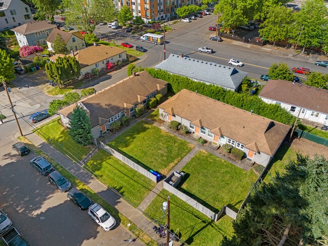
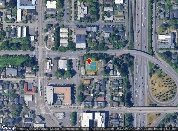
This Property Is For Sale
NEARBY LISTINGS FOR SALE OR LEASE
Property Detail
4515 N Montana Ave
Portland-Vancouver-Hillsboro, OR-WA
M Pattons Add & 2Nd
R210483
M PATTONS ADD & 2ND, BLOCK 10, S 46 OF LOT 6, N 46 OF LOT 7
Quadruplex
Multnomah
ARE
Oregon
41067C0400E
6,7
2025
0.22 AC
2025
Humboldt
003502
Portland
2,250 SF
DEMOGRAPHICS near 4515 N Montana Ave
1 Mile
3 Mile
5 Mile
2024 Total Population
23,960
176,671
345,316
2029 Population
23,888
173,582
338,511
Pop Growth 2024-2029
(0.30%)
(1.75%)
(1.97%)
Average Age
38
40
41
2024 Total Households
11,054
87,440
164,173
HH Growth 2024-2029
(0.71%)
(1.87%)
(2.07%)
Median Household Inc
$94,709
$82,634
$88,738
Avg Household Size
2.10
1.90
2.00
2024 Avg HH Vehicles
2.00
1.00
1.00
Median Home Value
$648,189
$665,677
$658,604
Median Year Built
1953
1963
1962
Nearby Places
- Restaurants
- Banks
- Shops
- Fitness
- Groceries
PUBLIC TRANSPORTATION
TRANSIT/SUBWAY
N Prescott (MAX Yellow Line - Tri-County Metropolitan Transportation District of Oregon Rail (TriMet Rail))
DRIVE
WALK
Distance
N Prescott (MAX Yellow Line - Tri-County Metropolitan Transportation District of Oregon Rail (TriMet Rail))
1 min
4 min
0.2 mi
N Killingsworth (MAX Yellow Line - Tri-County Metropolitan Transportation District of Oregon Rail (TriMet Rail))
DRIVE
WALK
Distance
N Killingsworth (MAX Yellow Line - Tri-County Metropolitan Transportation District of Oregon Rail (TriMet Rail))
2 min
12 min
0.6 mi
Overlook Park (MAX Yellow Line - Tri-County Metropolitan Transportation District of Oregon Rail (TriMet Rail))
DRIVE
WALK
Distance
Overlook Park (MAX Yellow Line - Tri-County Metropolitan Transportation District of Oregon Rail (TriMet Rail))
3 min
12 min
0.6 mi
COMMUTER RAIL
DRIVE
WALK
Distance
6 min
2.6 mi
DRIVE
WALK
Distance
13 min
6.8 mi
AIRPORT
Portland International
DRIVE
WALK
Distance
Portland International
20 min
9.0 mi
Freight Ports
Port of Portland
DRIVE
WALK
Distance
Port of Portland
7 min
3.3 mi
Nearby Properties
Address
Land Use
TOTAL SIZE
Lot Size
Zoning
Address
Land Use
TOTAL SIZE
Lot Size
Zoning
395,815 SF
2.66 AC
IRD
Address
Land Use
TOTAL SIZE
Lot Size
Zoning
627,500 SF
16.60 AC
CX
Address
Land Use
TOTAL SIZE
Lot Size
Zoning
882,480 SF
80.73 AC
CI1
Address
Land Use
TOTAL SIZE
Lot Size
Zoning
560,000 SF
0.15 AC
CX
Address
Land Use
TOTAL SIZE
Lot Size
Zoning
20.71 AC
OS
Address
Land Use
TOTAL SIZE
Lot Size
Zoning
326,547 SF
2.42 AC
RH
Address
Land Use
TOTAL SIZE
Lot Size
Zoning
304,836 SF
10.85 AC
CX
Address
Land Use
TOTAL SIZE
Lot Size
Zoning
417,324 SF
0.68 AC
CX
Address
Land Use
TOTAL SIZE
Lot Size
Zoning
257,700 SF
2.89 AC
EX
Address
Land Use
TOTAL SIZE
Lot Size
Zoning
178,785 SF
10.20 AC
R5
Address
Land Use
TOTAL SIZE
Lot Size
Zoning
128,500 SF
6.95 AC
OS
Address
Land Use
TOTAL SIZE
Lot Size
Zoning
460,000 SF
0.92 AC
CX
Address
Land Use
TOTAL SIZE
Lot Size
Zoning
689,840 SF
0.92 AC
CX
Address
Land Use
TOTAL SIZE
Lot Size
Zoning
125,217 SF
0.23 AC
CX
Address
Land Use
TOTAL SIZE
Lot Size
Zoning
7.78 AC
EX
Address
Land Use
TOTAL SIZE
Lot Size
Zoning
Address
Land Use
TOTAL SIZE
Lot Size
Zoning
Address
Land Use
TOTAL SIZE
Lot Size
Zoning
426,742 SF
0.53 AC
RXD
Address
Land Use
TOTAL SIZE
Lot Size
Zoning
243,371 SF
0.67 AC
CI2
Address
Land Use
TOTAL SIZE
Lot Size
Zoning
584,483 SF
0.90 AC
CX
Address
Land Use
TOTAL SIZE
Lot Size
Zoning
645,294 SF
5.64 AC
CO2D
Address
Land Use
TOTAL SIZE
Lot Size
Zoning
247,520 SF
7.74 AC
CX
Address
Land Use
TOTAL SIZE
Lot Size
Zoning
306,000 SF
1.21 AC
NULL
Address
Land Use
TOTAL SIZE
Lot Size
Zoning
596,161 SF
0.92 AC
CX
Address
Land Use
TOTAL SIZE
Lot Size
Zoning
456,760 SF
0.53 AC
EX
Address
Land Use
TOTAL SIZE
Lot Size
Zoning
193,898 SF
2.50 AC
IRD
Address
Land Use
TOTAL SIZE
Lot Size
Zoning
134,398 SF
3.17 AC
CG
Address
Land Use
TOTAL SIZE
Lot Size
Zoning
387,000 SF
0.88 AC
CXD
Address
Land Use
TOTAL SIZE
Lot Size
Zoning
1,660,710 SF
110.33 AC
IG2
Address
Land Use
TOTAL SIZE
Lot Size
Zoning
291,451 SF
1.64 AC
RH
The World's #1 Commercial Real Estate Marketplace
Connect with us
© 2025 CoStar Group
The information above has been obtained from sources believed reliable. While we do not doubt its accuracy we have not verified it and make no guarantee, warranty or representation about it. It is your responsibility to independently confirm its accuracy and completeness. Any projections, opinions, assumptions, or estimates used are for example only and do not represent the current or future performance of the property. The value of this transaction to you depends on tax and other factors which should be evaluated by your tax, financial, and legal advisors. You and your advisors should conduct a careful, independent investigation of the property to determine to your satisfaction the suitability of the property for your needs.