Property Record
4519 N Garfield St, Midland, TX 79705
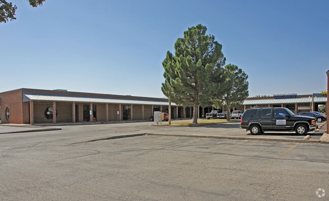

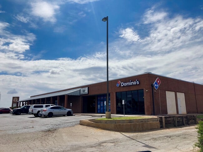
Property Detail
4519 N Garfield St
Midland, TX
ACRES: 3.298 BLK: 002 LOTS: 002 & 3 ADDN: HATFIELD SEC 4
R000024-446
Midland
Realpropertynec
Texas
LR2
2-3
2025
3.30 AC
2025
Midland & Odessa
000305
Other Market Areas
8,956 SF
NEARBY LISTINGS FOR SALE OR LEASE
DEMOGRAPHICS near 4519 N Garfield St
1 mile
3 mile
5 mile
2025 Total Population
9,858
78,770
143,455
2030 Population
10,757
86,947
158,570
Pop Growth 2025-2030
+ 9.12%
+ 10.38%
+ 10.54%
Average Age
38
36
35
2025 Total Households
4,214
30,863
52,915
HH Growth 2025-2030
+ 10.49%
+ 11.60%
+ 11.74%
Median Household Inc
$98,208
$94,387
$91,299
Avg Household Size
2.30
2.50
2.60
2025 Avg HH Vehicles
2.00
2.00
2.00
Median Home Value
$378,901
$343,567
$322,013
Median Year Built
1983
1984
1986
Nearby Places
Map Layers
Map Styles
 Street
 Aerial
Transit
 Traffic
 Biking
Places
Listings with unknown addresses are not visible on the map
- Restaurants
- Banks
- Shops
- Fitness
- Groceries
PUBLIC TRANSPORTATION
AIRPORT
Midland International Air And Space Port
Drive
Walk
Distance
Midland International Air And Space Port
19 min
13.2 mi
Freight Ports
Calhoun Port
Drive
Walk
Distance
Calhoun Port
531 min
476.6 mi
SALE & LEASE HISTORY
LISTING DATE
SALE/LEASE

May 29, 2020
For Lease
Nearby Properties
Address
Land Use
TOTAL SIZE
Lot Size
Zoning
Address
Land Use
TOTAL SIZE
Lot Size
Zoning
56,157 SF
18.19 AC
PDOC
Address
Land Use
TOTAL SIZE
Lot Size
Zoning
9,988 SF
17.46 AC
Address
Land Use
TOTAL SIZE
Lot Size
Zoning
8,290 SF
12.79 AC
Address
Land Use
TOTAL SIZE
Lot Size
Zoning
218,400 SF
14.12 AC
Address
Land Use
TOTAL SIZE
Lot Size
Zoning
5,178 SF
16.66 AC
PDOC
Address
Land Use
TOTAL SIZE
Lot Size
Zoning
94,059 SF
15.95 AC
PDMX
Address
Land Use
TOTAL SIZE
Lot Size
Zoning
37,220 SF
7.95 AC
O2
Address
Land Use
TOTAL SIZE
Lot Size
Zoning
28,571 SF
17.07 AC
Address
Land Use
TOTAL SIZE
Lot Size
Zoning
1,173 SF
14.05 AC
PDHD
Address
Land Use
TOTAL SIZE
Lot Size
Zoning
2,196 SF
15.11 AC
PDHD
Address
Land Use
TOTAL SIZE
Lot Size
Zoning
7,793 SF
15.51 AC
Address
Land Use
TOTAL SIZE
Lot Size
Zoning
1,770 SF
19.28 AC
PDHD
Address
Land Use
TOTAL SIZE
Lot Size
Zoning
262,640 SF
13.71 AC
MF1
Address
Land Use
TOTAL SIZE
Lot Size
Zoning
249,810 SF
9.42 AC
Address
Land Use
TOTAL SIZE
Lot Size
Zoning
676 SF
11.40 AC
Address
Land Use
TOTAL SIZE
Lot Size
Zoning
7,200 SF
17.74 AC
MF1
Address
Land Use
TOTAL SIZE
Lot Size
Zoning
600 SF
12.45 AC
MF1
Address
Land Use
TOTAL SIZE
Lot Size
Zoning
12,916 SF
0.71 AC
MF1
Address
Land Use
TOTAL SIZE
Lot Size
Zoning
7,526 SF
12 AC
MF1
Address
Land Use
TOTAL SIZE
Lot Size
Zoning
46,010 SF
13.02 AC
PDOC
Address
Land Use
TOTAL SIZE
Lot Size
Zoning
12,960 SF
15.93 AC
MF1
Address
Land Use
TOTAL SIZE
Lot Size
Zoning
2,049 SF
8.79 AC
MF1
Address
Land Use
TOTAL SIZE
Lot Size
Zoning
1,725 SF
11.98 AC
MF1
Address
Land Use
TOTAL SIZE
Lot Size
Zoning
109,881 SF
10.38 AC
MF1
Address
Land Use
TOTAL SIZE
Lot Size
Zoning
5,884 SF
22.97 AC
PDSC
Address
Land Use
TOTAL SIZE
Lot Size
Zoning
7,200 SF
10.68 AC
MF1
Address
Land Use
TOTAL SIZE
Lot Size
Zoning
904 SF
11.34 AC
MF1
Address
Land Use
TOTAL SIZE
Lot Size
Zoning
1,369 SF
8.69 AC
MF1
Address
Land Use
TOTAL SIZE
Lot Size
Zoning
1,678 SF
9.11 AC
MF1
Address
Land Use
TOTAL SIZE
Lot Size
Zoning
1,980 SF
10.25 AC
MF1
The World's #1 Commercial Real Estate Marketplace
Connect with us
© 2026 CoStar Group
The information above has been obtained from sources believed reliable. While we do not doubt its accuracy we have not verified it and make no guarantee, warranty or representation about it. It is your responsibility to independently confirm its accuracy and completeness. Any projections, opinions, assumptions, or estimates used are for example only and do not represent the current or future performance of the property. The value of this transaction to you depends on tax and other factors which should be evaluated by your tax, financial, and legal advisors. You and your advisors should conduct a careful, independent investigation of the property to determine to your satisfaction the suitability of the property for your needs.