Property Record
452 Ada Dr Se, Ada, MI 49301
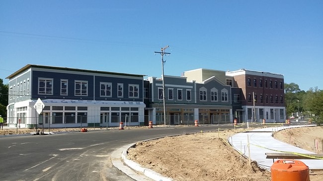

Property Detail
452 Ada Dr Se
41-15-34-128-002
411534128002 UNIT 2 * MARKETPLACE SQUARE CONDOMINIUM KENT COUNTY CONDOMINIUM SUBDIVISION PLAN NO.1024 INSTRUMENT
Commercialnec
Kent
C and X Area of minimal flood hazard, usually depicted on FIRMs as above the 500-year flood level.
Michigan
2024
0.28 AC
2025
Ada/Lowell
011902
West Michigan
22,848 SF
Grand Rapids-Wyoming-Kentwood, MI
NEARBY LISTINGS FOR SALE OR LEASE
-
-
View all Ada listings for sale on LoopNet.com
DEMOGRAPHICS near 452 Ada Dr Se
1 mile
3 mile
5 mile
2025 Total Population
2,360
19,239
48,927
2030 Population
2,458
19,895
50,475
Pop Growth 2025-2030
+ 4.15%
+ 3.41%
+ 3.16%
Average Age
40
41
41
2025 Total Households
788
6,656
17,298
HH Growth 2025-2030
+ 4.31%
+ 3.49%
+ 3.31%
Median Household Inc
$188,809
$155,787
$130,138
Avg Household Size
2.90
2.90
2.70
2025 Avg HH Vehicles
2.00
2.00
2.00
Median Home Value
$472,182
$496,093
$461,162
Median Year Built
1992
1991
1988
Nearby Places
Map Layers
Map Styles
 Street
 Aerial
Layers
 Traffic
 Biking
Places
Listings with unknown addresses are not visible on the map
- Restaurants
- Banks
- Shops
- Fitness
- Groceries
PUBLIC TRANSPORTATION
AIRPORT
Gerald R Ford International
Drive
Walk
Distance
Gerald R Ford International
22 min
10.9 mi
Freight Ports
Port Milwaukee
Drive
Walk
Distance
Port Milwaukee
317 min
273.1 mi
Nearby Properties
Address
Land Use
TOTAL SIZE
Lot Size
Zoning
Address
Land Use
TOTAL SIZE
Lot Size
Zoning
277.36 AC
I
Address
Land Use
TOTAL SIZE
Lot Size
Zoning
226,877 SF
22.40 AC
R2
Address
Land Use
TOTAL SIZE
Lot Size
Zoning
8.97 AC
Address
Land Use
TOTAL SIZE
Lot Size
Zoning
Address
Land Use
TOTAL SIZE
Lot Size
Zoning
Address
Land Use
TOTAL SIZE
Lot Size
Zoning
14,700 SF
1.44 AC
Address
Land Use
TOTAL SIZE
Lot Size
Zoning
0.65 AC
Address
Land Use
TOTAL SIZE
Lot Size
Zoning
Address
Land Use
TOTAL SIZE
Lot Size
Zoning
64,790 SF
290,921.90 AC
PUD
Address
Land Use
TOTAL SIZE
Lot Size
Zoning
29,224 SF
5.48 AC
I
Address
Land Use
TOTAL SIZE
Lot Size
Zoning
0.20 AC
Address
Land Use
TOTAL SIZE
Lot Size
Zoning
4,600 SF
0.64 AC
Address
Land Use
TOTAL SIZE
Lot Size
Zoning
39,312 SF
7.01 AC
R2
Address
Land Use
TOTAL SIZE
Lot Size
Zoning
79,921 SF
420,750 AC
PUD
Address
Land Use
TOTAL SIZE
Lot Size
Zoning
0.92 AC
C1
Address
Land Use
TOTAL SIZE
Lot Size
Zoning
87,210 SF
4 AC
I
Address
Land Use
TOTAL SIZE
Lot Size
Zoning
34,276 SF
6.40 AC
PO
Address
Land Use
TOTAL SIZE
Lot Size
Zoning
9,414 SF
1.64 AC
Address
Land Use
TOTAL SIZE
Lot Size
Zoning
19,610 SF
R1
Address
Land Use
TOTAL SIZE
Lot Size
Zoning
0.44 AC
Address
Land Use
TOTAL SIZE
Lot Size
Zoning
0.17 AC
Address
Land Use
TOTAL SIZE
Lot Size
Zoning
1.24 AC
Address
Land Use
TOTAL SIZE
Lot Size
Zoning
45,872 SF
4.53 AC
I
Address
Land Use
TOTAL SIZE
Lot Size
Zoning
0.64 AC
Address
Land Use
TOTAL SIZE
Lot Size
Zoning
2.84 AC
Address
Land Use
TOTAL SIZE
Lot Size
Zoning
24,602 SF
59.48 AC
R1
Address
Land Use
TOTAL SIZE
Lot Size
Zoning
6,357 SF
4.57 AC
I
Address
Land Use
TOTAL SIZE
Lot Size
Zoning
4,154 SF
0.27 AC
Address
Land Use
TOTAL SIZE
Lot Size
Zoning
234.79 AC
The World's #1 Commercial Real Estate Marketplace
Connect with us
© 2026 CoStar Group
The information above has been obtained from sources believed reliable. While we do not doubt its accuracy we have not verified it and make no guarantee, warranty or representation about it. It is your responsibility to independently confirm its accuracy and completeness. Any projections, opinions, assumptions, or estimates used are for example only and do not represent the current or future performance of the property. The value of this transaction to you depends on tax and other factors which should be evaluated by your tax, financial, and legal advisors. You and your advisors should conduct a careful, independent investigation of the property to determine to your satisfaction the suitability of the property for your needs.