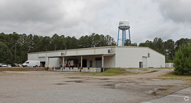
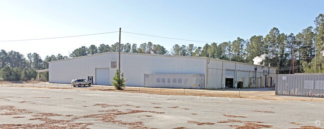
Property Record
452 E Boundary St, Chapin, SC 29036

Property Detail
452 E Boundary St
000700-03-024
PARCEL 1
Warehouse
Lexington
GC
South Carolina
B and X Area of moderate flood hazard, usually the area between the limits of the 100-year and 500-year floods.
3.68 AC
2025
Dutch Fork/Irmo
2024
Columbia
021204
Columbia, SC
26,000 SF
NEARBY LISTINGS FOR SALE OR LEASE
-
-
View all Chapin listings for sale on LoopNet.com
DEMOGRAPHICS near 452 E Boundary St
1 mile
3 mile
5 mile
2025 Total Population
1,823
9,260
26,630
2030 Population
1,918
9,691
27,885
Pop Growth 2025-2030
+ 5.21%
+ 4.65%
+ 4.71%
Average Age
39
40
42
2025 Total Households
692
3,480
10,026
HH Growth 2025-2030
+ 5.35%
+ 4.89%
+ 4.92%
Median Household Inc
$87,372
$89,733
$111,305
Avg Household Size
2.60
2.60
2.60
2025 Avg HH Vehicles
2.00
2.00
2.00
Median Home Value
$279,186
$309,284
$388,672
Median Year Built
2003
2000
2001
Nearby Places
Map Layers
Map Styles
 Street
 Aerial
Layers
 Traffic
 Biking
Places
Listings with unknown addresses are not visible on the map
- Restaurants
- Banks
- Shops
- Fitness
- Groceries
PUBLIC TRANSPORTATION
AIRPORT
Columbia Metro
Drive
Walk
Distance
Columbia Metro
47 min
28.7 mi
Nearby Properties
Address
Land Use
TOTAL SIZE
Lot Size
Zoning
Address
Land Use
TOTAL SIZE
Lot Size
Zoning
20,344 SF
13.21 AC
RU
Address
Land Use
TOTAL SIZE
Lot Size
Zoning
10,764 SF
1.84 AC
GC
Address
Land Use
TOTAL SIZE
Lot Size
Zoning
60.57 AC
RU
Address
Land Use
TOTAL SIZE
Lot Size
Zoning
87.84 AC
Address
Land Use
TOTAL SIZE
Lot Size
Zoning
46,031 SF
12.16 AC
GC
Address
Land Use
TOTAL SIZE
Lot Size
Zoning
88 AC
RU
Address
Land Use
TOTAL SIZE
Lot Size
Zoning
67.59 AC
RU
Address
Land Use
TOTAL SIZE
Lot Size
Zoning
960 SF
45 AC
RU
Address
Land Use
TOTAL SIZE
Lot Size
Zoning
3,848 SF
1.13 AC
RU
Address
Land Use
TOTAL SIZE
Lot Size
Zoning
61,972 SF
7.82 AC
GC
Address
Land Use
TOTAL SIZE
Lot Size
Zoning
8,960 SF
0.75 AC
GC
Address
Land Use
TOTAL SIZE
Lot Size
Zoning
24.64 AC
Address
Land Use
TOTAL SIZE
Lot Size
Zoning
66,432 SF
2.89 AC
GC
Address
Land Use
TOTAL SIZE
Lot Size
Zoning
100,075 SF
12.10 AC
LM
Address
Land Use
TOTAL SIZE
Lot Size
Zoning
1,984 SF
1.36 AC
GC
Address
Land Use
TOTAL SIZE
Lot Size
Zoning
0.83 AC
GC
Address
Land Use
TOTAL SIZE
Lot Size
Zoning
46,244 SF
2.50 AC
INC
Address
Land Use
TOTAL SIZE
Lot Size
Zoning
18.55 AC
RU
Address
Land Use
TOTAL SIZE
Lot Size
Zoning
20,595 SF
5.09 AC
GC
Address
Land Use
TOTAL SIZE
Lot Size
Zoning
43,119 SF
5.99 AC
GC
Address
Land Use
TOTAL SIZE
Lot Size
Zoning
32,737 SF
4.76 AC
ID
Address
Land Use
TOTAL SIZE
Lot Size
Zoning
11,300 SF
1.23 AC
ID
Address
Land Use
TOTAL SIZE
Lot Size
Zoning
7.08 AC
RU
Address
Land Use
TOTAL SIZE
Lot Size
Zoning
31,790 SF
16.26 AC
Address
Land Use
TOTAL SIZE
Lot Size
Zoning
13,310 SF
1.46 AC
GC
Address
Land Use
TOTAL SIZE
Lot Size
Zoning
2,400 SF
9.76 AC
RU
Address
Land Use
TOTAL SIZE
Lot Size
Zoning
15,302 SF
24.12 AC
OC
Address
Land Use
TOTAL SIZE
Lot Size
Zoning
35,515 SF
5.72 AC
GC
Address
Land Use
TOTAL SIZE
Lot Size
Zoning
18,201 SF
4.43 AC
GC
Address
Land Use
TOTAL SIZE
Lot Size
Zoning
5,124 SF
3.91 AC
GC
The World's #1 Commercial Real Estate Marketplace
Connect with us
© 2026 CoStar Group
The information above has been obtained from sources believed reliable. While we do not doubt its accuracy we have not verified it and make no guarantee, warranty or representation about it. It is your responsibility to independently confirm its accuracy and completeness. Any projections, opinions, assumptions, or estimates used are for example only and do not represent the current or future performance of the property. The value of this transaction to you depends on tax and other factors which should be evaluated by your tax, financial, and legal advisors. You and your advisors should conduct a careful, independent investigation of the property to determine to your satisfaction the suitability of the property for your needs.