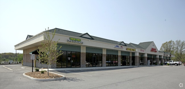
Property Record
452 Highway P, O Fallon, MO 63366
NEARBY LISTINGS FOR SALE OR LEASE
Property Detail
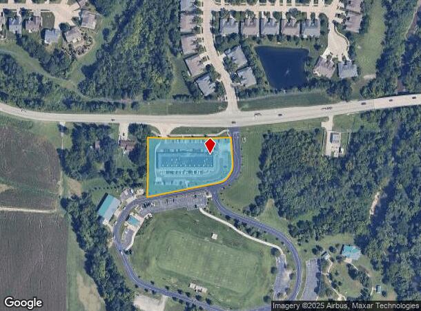
452 Highway P
St. Louis, MO-IL
Dames Sports Pk
2-0121-9573-00-0001.0000000
DAMES SPORTS PK LOT 1
Commercialnec
St. Charles
AE
Missouri
29183C0230G
1
2024
1.88 AC
2025
Outer St Charles Cnty
311801
St. Louis
14,520 SF
DEMOGRAPHICS near 452 Highway P
1 Mile
3 Mile
5 Mile
2024 Total Population
7,424
38,055
108,761
2029 Population
7,807
40,245
115,201
Pop Growth 2024-2029
+ 5.16%
+ 5.75%
+ 5.92%
Average Age
42
41
40
2024 Total Households
2,889
14,964
40,544
HH Growth 2024-2029
+ 5.16%
+ 5.79%
+ 5.95%
Median Household Inc
$89,662
$81,658
$96,324
Avg Household Size
2.50
2.50
2.60
2024 Avg HH Vehicles
2.00
2.00
2.00
Median Home Value
$252,862
$257,494
$273,669
Median Year Built
1998
1998
1996
Nearby Places
Map Layers
Map Styles
 Street
 Aerial
- Restaurants
- Banks
- Shops
- Fitness
- Groceries
PUBLIC TRANSPORTATION
AIRPORT
St Louis Lambert International
DRIVE
WALK
Distance
St Louis Lambert International
34 min
24.2 mi
Freight Ports
Port Milwaukee
DRIVE
WALK
Distance
Port Milwaukee
454 min
397.3 mi
SALE & LEASE HISTORY
LISTING DATE
SALE/LEASE

Mar 15, 2019
For Lease
Nearby Properties
Address
Land Use
TOTAL SIZE
Lot Size
Zoning
Address
Land Use
TOTAL SIZE
Lot Size
Zoning
189,054 SF
24.92 AC
AA1
Address
Land Use
TOTAL SIZE
Lot Size
Zoning
254,435 SF
16.57 AC
Address
Land Use
TOTAL SIZE
Lot Size
Zoning
342,840 SF
58.93 AC
AB6
Address
Land Use
TOTAL SIZE
Lot Size
Zoning
235,876 SF
11.35 AC
Address
Land Use
TOTAL SIZE
Lot Size
Zoning
46,388 SF
10.76 AC
Address
Land Use
TOTAL SIZE
Lot Size
Zoning
75.10 AC
AC7
Address
Land Use
TOTAL SIZE
Lot Size
Zoning
591,516 SF
28.79 AC
AB2
Address
Land Use
TOTAL SIZE
Lot Size
Zoning
32.19 AC
AA1
Address
Land Use
TOTAL SIZE
Lot Size
Zoning
36,438 SF
2.08 AC
AC4
Address
Land Use
TOTAL SIZE
Lot Size
Zoning
251,169 SF
20.19 AC
Address
Land Use
TOTAL SIZE
Lot Size
Zoning
562,434 SF
40.73 AC
AB3
Address
Land Use
TOTAL SIZE
Lot Size
Zoning
210,095 SF
12.29 AC
AE9
Address
Land Use
TOTAL SIZE
Lot Size
Zoning
53,636 SF
Address
Land Use
TOTAL SIZE
Lot Size
Zoning
48.76 AC
AF0
Address
Land Use
TOTAL SIZE
Lot Size
Zoning
197,791 SF
18.58 AC
Address
Land Use
TOTAL SIZE
Lot Size
Zoning
129,472 SF
22 AC
AC2
Address
Land Use
TOTAL SIZE
Lot Size
Zoning
147,526 SF
7.51 AC
AE8
Address
Land Use
TOTAL SIZE
Lot Size
Zoning
40,804 SF
7.98 AC
Address
Land Use
TOTAL SIZE
Lot Size
Zoning
57.96 AC
Address
Land Use
TOTAL SIZE
Lot Size
Zoning
22,542 SF
3.64 AC
Address
Land Use
TOTAL SIZE
Lot Size
Zoning
49,680 SF
1.15 AC
Address
Land Use
TOTAL SIZE
Lot Size
Zoning
198,534 SF
8.87 AC
AB3
Address
Land Use
TOTAL SIZE
Lot Size
Zoning
9,890 SF
1.51 AC
Address
Land Use
TOTAL SIZE
Lot Size
Zoning
139,792 SF
16.47 AC
AB2
Address
Land Use
TOTAL SIZE
Lot Size
Zoning
41.41 AC
AD9
Address
Land Use
TOTAL SIZE
Lot Size
Zoning
10.41 AC
Address
Land Use
TOTAL SIZE
Lot Size
Zoning
35.34 AC
Address
Land Use
TOTAL SIZE
Lot Size
Zoning
69,500 SF
9.39 AC
Address
Land Use
TOTAL SIZE
Lot Size
Zoning
55,323 SF
8.44 AC
AC4
Address
Land Use
TOTAL SIZE
Lot Size
Zoning
13.97 AC
The World's #1 Commercial Real Estate Marketplace
Connect with us
© 2026 CoStar Group
The information above has been obtained from sources believed reliable. While we do not doubt its accuracy we have not verified it and make no guarantee, warranty or representation about it. It is your responsibility to independently confirm its accuracy and completeness. Any projections, opinions, assumptions, or estimates used are for example only and do not represent the current or future performance of the property. The value of this transaction to you depends on tax and other factors which should be evaluated by your tax, financial, and legal advisors. You and your advisors should conduct a careful, independent investigation of the property to determine to your satisfaction the suitability of the property for your needs.