Property Record
452 John L Dietsch Blvd, Attleboro Falls, MA 02763
NEARBY LISTINGS FOR SALE OR LEASE
Property Detail
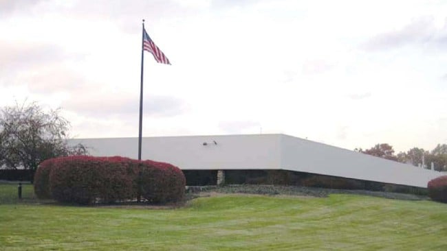
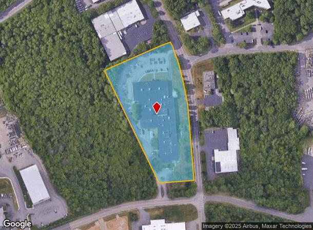
452 John L Dietsch Blvd
Manufacturinglight
Bristol
X
Massachusetts
25005C0106G
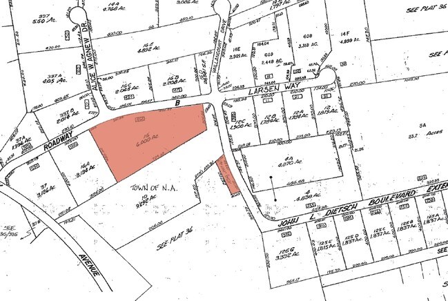
6 AC
2025
Attleboro/New Bedford
2025
Boston
630202
Providence-Warwick, RI-MA
71,838 SF
NATT-000034A-000016
DEMOGRAPHICS near 452 John L Dietsch Blvd
1 Mile
3 Mile
5 Mile
2024 Total Population
3,859
47,112
90,361
2029 Population
3,888
46,839
89,916
Pop Growth 2024-2029
+ 0.75%
(0.58%)
(0.49%)
Average Age
40
41
41
2024 Total Households
1,282
18,831
35,588
HH Growth 2024-2029
+ 0.62%
(0.66%)
(0.54%)
Median Household Inc
$142,045
$98,587
$99,381
Avg Household Size
3.00
2.50
2.50
2024 Avg HH Vehicles
2.00
2.00
2.00
Median Home Value
$454,407
$421,355
$434,523
Median Year Built
1977
1974
1974
Nearby Places
Map Layers
Map Styles
 Street
 Aerial
- Restaurants
- Banks
- Shops
- Fitness
- Groceries
PUBLIC TRANSPORTATION
COMMUTER RAIL
Attleboro (Providence/Stoughton Line - Massachusetts Bay Transportation Authority Commuter Rail (Purple Line))
DRIVE
WALK
Distance
Attleboro (Providence/Stoughton Line - Massachusetts Bay Transportation Authority Commuter Rail (Purple Line))
9 min
4.0 mi
DRIVE
WALK
Distance
10 min
4.2 mi
Nearby Properties
Address
Land Use
TOTAL SIZE
Lot Size
Zoning
Address
Land Use
TOTAL SIZE
Lot Size
Zoning
65.21 AC
Address
Land Use
TOTAL SIZE
Lot Size
Zoning
98,369 SF
5.53 AC
IC30
Address
Land Use
TOTAL SIZE
Lot Size
Zoning
5,022 SF
22.90 AC
RB
Address
Land Use
TOTAL SIZE
Lot Size
Zoning
13.93 AC
CB
Address
Land Use
TOTAL SIZE
Lot Size
Zoning
17,782 SF
25.60 AC
Address
Land Use
TOTAL SIZE
Lot Size
Zoning
Address
Land Use
TOTAL SIZE
Lot Size
Zoning
8,432 SF
46 AC
Address
Land Use
TOTAL SIZE
Lot Size
Zoning
Address
Land Use
TOTAL SIZE
Lot Size
Zoning
8.29 AC
R10
Address
Land Use
TOTAL SIZE
Lot Size
Zoning
79,322 SF
12.54 AC
R15
Address
Land Use
TOTAL SIZE
Lot Size
Zoning
16.82 AC
C60
Address
Land Use
TOTAL SIZE
Lot Size
Zoning
9.52 AC
C7.5
Address
Land Use
TOTAL SIZE
Lot Size
Zoning
89,052 SF
17 AC
Address
Land Use
TOTAL SIZE
Lot Size
Zoning
72,331 SF
22.50 AC
Address
Land Use
TOTAL SIZE
Lot Size
Zoning
6.88 AC
CA
Address
Land Use
TOTAL SIZE
Lot Size
Zoning
12,958 SF
5.50 AC
Address
Land Use
TOTAL SIZE
Lot Size
Zoning
91,126 SF
9.71 AC
I60
Address
Land Use
TOTAL SIZE
Lot Size
Zoning
36,424 SF
1.18 AC
IC3
Address
Land Use
TOTAL SIZE
Lot Size
Zoning
53,375 SF
10.14 AC
IC30
Address
Land Use
TOTAL SIZE
Lot Size
Zoning
104,003 SF
9.92 AC
I60
Address
Land Use
TOTAL SIZE
Lot Size
Zoning
1,656 SF
4.66 AC
R15
Address
Land Use
TOTAL SIZE
Lot Size
Zoning
3.59 AC
IC3
Address
Land Use
TOTAL SIZE
Lot Size
Zoning
13,555 SF
14.70 AC
I
Address
Land Use
TOTAL SIZE
Lot Size
Zoning
44,486 SF
0.14 AC
Address
Land Use
TOTAL SIZE
Lot Size
Zoning
7.80 AC
Address
Land Use
TOTAL SIZE
Lot Size
Zoning
70,770 SF
11.52 AC
C60
Address
Land Use
TOTAL SIZE
Lot Size
Zoning
80,293 SF
7.58 AC
I
Address
Land Use
TOTAL SIZE
Lot Size
Zoning
52,259 SF
21.94 AC
Address
Land Use
TOTAL SIZE
Lot Size
Zoning
5.76 AC
IC3
Address
Land Use
TOTAL SIZE
Lot Size
Zoning
56,161 SF
23.70 AC
I60
The World's #1 Commercial Real Estate Marketplace
Connect with us
© 2025 CoStar Group
The information above has been obtained from sources believed reliable. While we do not doubt its accuracy we have not verified it and make no guarantee, warranty or representation about it. It is your responsibility to independently confirm its accuracy and completeness. Any projections, opinions, assumptions, or estimates used are for example only and do not represent the current or future performance of the property. The value of this transaction to you depends on tax and other factors which should be evaluated by your tax, financial, and legal advisors. You and your advisors should conduct a careful, independent investigation of the property to determine to your satisfaction the suitability of the property for your needs.