Property Record
4520 New Horizon Blvd, Bakersfield, CA 93313
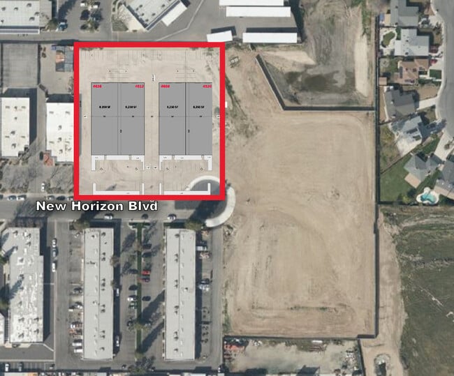
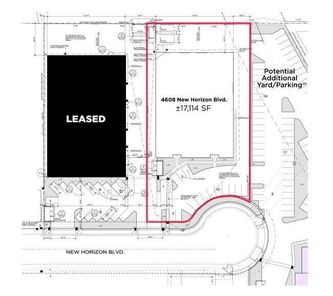
Current Lease Availabilities
NEARBY LISTINGS FOR SALE OR LEASE
-
-
-
-
No Photo
-
-
-
-
View all Bakersfield listings for lease on LoopNet.com
Property Detail
4520 New Horizon Blvd
Bakersfield, CA
PARCEL MAP 5733 , LOT PN21
404-111-29-00-8
Kern
Industrialacreage
California
X
pn21
06029C2300E
0.47 AC
2024
Southwest Bakersfield
2025
Bakersfield
003209
DEMOGRAPHICS near 4520 New Horizon Blvd
1 Mile
3 Mile
5 Mile
2024 Total Population
15,210
167,864
286,525
2029 Population
15,132
167,689
286,644
Pop Growth 2024-2029
(0.51%)
(0.10%)
+ 0.04%
Average Age
35
34
35
2024 Total Households
4,906
52,165
89,084
HH Growth 2024-2029
(0.57%)
(0.15%)
(0.01%)
Median Household Inc
$51,800
$61,481
$63,684
Avg Household Size
3.00
3.10
3.10
2024 Avg HH Vehicles
2.00
2.00
2.00
Median Home Value
$232,294
$266,016
$279,536
Median Year Built
1978
1981
1983
Nearby Places
Map Layers
Map Styles
 Street
 Aerial
- Restaurants
- Banks
- Shops
- Fitness
- Groceries
PUBLIC TRANSPORTATION
COMMUTER RAIL
Bakersfield (San Joaquins - Amtrak)
DRIVE
WALK
Distance
Bakersfield (San Joaquins - Amtrak)
13 min
7.7 mi
AIRPORT
Meadows Field
DRIVE
WALK
Distance
Meadows Field
21 min
11.2 mi
Freight Ports
The Port of Hueneme
DRIVE
WALK
Distance
The Port of Hueneme
149 min
119.4 mi
Nearby Properties
Address
Land Use
TOTAL SIZE
Lot Size
Zoning
Address
Land Use
TOTAL SIZE
Lot Size
Zoning
587,976 SF
40.01 AC
M-2
Address
Land Use
TOTAL SIZE
Lot Size
Zoning
23,615 SF
39.38 AC
C2
Address
Land Use
TOTAL SIZE
Lot Size
Zoning
114,500 SF
12.02 AC
C-2
Address
Land Use
TOTAL SIZE
Lot Size
Zoning
354,000 SF
20 AC
M2
Address
Land Use
TOTAL SIZE
Lot Size
Zoning
14,529 SF
27.73 AC
R-2
Address
Land Use
TOTAL SIZE
Lot Size
Zoning
185,181 SF
14.67 AC
C2
Address
Land Use
TOTAL SIZE
Lot Size
Zoning
269,429 SF
12.71 AC
R-2
Address
Land Use
TOTAL SIZE
Lot Size
Zoning
218,345 SF
19.54 AC
PCD
Address
Land Use
TOTAL SIZE
Lot Size
Zoning
37,760 SF
12.16 AC
R3
Address
Land Use
TOTAL SIZE
Lot Size
Zoning
233,512 SF
9.19 AC
R-3
Address
Land Use
TOTAL SIZE
Lot Size
Zoning
214,746 SF
14.91 AC
Address
Land Use
TOTAL SIZE
Lot Size
Zoning
93,274 SF
6.20 AC
R-2
Address
Land Use
TOTAL SIZE
Lot Size
Zoning
223,557 SF
21.31 AC
PCD
Address
Land Use
TOTAL SIZE
Lot Size
Zoning
66,849 SF
5.32 AC
CO
Address
Land Use
TOTAL SIZE
Lot Size
Zoning
62,941 SF
8.79 AC
M-1
Address
Land Use
TOTAL SIZE
Lot Size
Zoning
79,325 SF
7.77 AC
C-2
Address
Land Use
TOTAL SIZE
Lot Size
Zoning
88,988 SF
9.82 AC
C-2
Address
Land Use
TOTAL SIZE
Lot Size
Zoning
11,780 SF
11.25 AC
C1
Address
Land Use
TOTAL SIZE
Lot Size
Zoning
115,267 SF
9.14 AC
C-2
Address
Land Use
TOTAL SIZE
Lot Size
Zoning
23,600 SF
8.17 AC
C2
Address
Land Use
TOTAL SIZE
Lot Size
Zoning
135,549 SF
12 AC
M1
Address
Land Use
TOTAL SIZE
Lot Size
Zoning
5,756 SF
9.70 AC
C-2-D
Address
Land Use
TOTAL SIZE
Lot Size
Zoning
32,749 SF
8.84 AC
R-2
Address
Land Use
TOTAL SIZE
Lot Size
Zoning
147,451 SF
9.55 AC
C2
Address
Land Use
TOTAL SIZE
Lot Size
Zoning
58,496 SF
7.32 AC
Address
Land Use
TOTAL SIZE
Lot Size
Zoning
69,414 SF
4.47 AC
M1
Address
Land Use
TOTAL SIZE
Lot Size
Zoning
12,008 SF
7.18 AC
Address
Land Use
TOTAL SIZE
Lot Size
Zoning
123,844 SF
7.49 AC
R-3
Address
Land Use
TOTAL SIZE
Lot Size
Zoning
83,857 SF
5.01 AC
Address
Land Use
TOTAL SIZE
Lot Size
Zoning
149,499 SF
13.20 AC
GC
The World's #1 Commercial Real Estate Marketplace
Connect with us
© 2025 CoStar Group
The information above has been obtained from sources believed reliable. While we do not doubt its accuracy we have not verified it and make no guarantee, warranty or representation about it. It is your responsibility to independently confirm its accuracy and completeness. Any projections, opinions, assumptions, or estimates used are for example only and do not represent the current or future performance of the property. The value of this transaction to you depends on tax and other factors which should be evaluated by your tax, financial, and legal advisors. You and your advisors should conduct a careful, independent investigation of the property to determine to your satisfaction the suitability of the property for your needs.