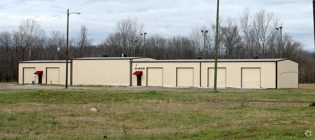
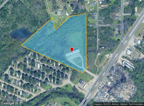
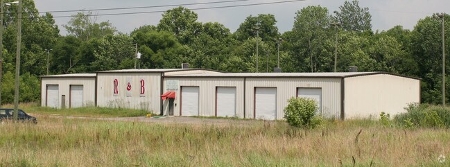
Property Record
4520 Bessemer Super Hwy, Brighton, AL 35020
NEARBY LISTINGS FOR SALE OR LEASE
Property Detail
4520 Bessemer Super Hwy
Birmingham-Hoover, AL
Bush Sub
30-00-27-4-011-033.000
BEGIN AT THE NE COR OF PARCEL SAID PT BEING AT THE NW COR OF LOT 50 W D BUSH SUB OF PARKER SPRINGS TH S 730 FT TH E 26 FT TO AN UNNAMED R/W TH SWLY 115 FT ALONG UNNAMED R/W TH NWLY 935 FT TH NELY 580 FT TH SLY 170 FT TH NELY 262 FT TH ELY 240 FT TO P
Amusementpark
Jefferson
AE
Alabama
01073C0537H
50
2023
9.30 AC
2024
Bessemer
013601
Birmingham
9,760 SF
DEMOGRAPHICS near 4520 Bessemer Super Hwy
1 Mile
3 Mile
5 Mile
2024 Total Population
6,945
37,338
101,496
2029 Population
7,017
37,094
100,582
Pop Growth 2024-2029
+ 1.04%
(0.65%)
(0.90%)
Average Age
41
41
40
2024 Total Households
2,764
15,037
41,113
HH Growth 2024-2029
+ 0.83%
(0.75%)
(1.02%)
Median Household Inc
$41,046
$42,405
$44,114
Avg Household Size
2.40
2.40
2.40
2024 Avg HH Vehicles
2.00
2.00
2.00
Median Home Value
$74,660
$101,584
$111,170
Median Year Built
1963
1962
1965
Nearby Places
Map Layers
Map Styles
 Street
 Aerial
- Restaurants
- Banks
- Shops
- Fitness
- Groceries
PUBLIC TRANSPORTATION
AIRPORT
Birmingham-Shuttlesworth International
DRIVE
WALK
Distance
Birmingham-Shuttlesworth International
25 min
17.2 mi
Nearby Properties
Address
Land Use
TOTAL SIZE
Lot Size
Zoning
Address
Land Use
TOTAL SIZE
Lot Size
Zoning
75,840 SF
20.10 AC
I3
Address
Land Use
TOTAL SIZE
Lot Size
Zoning
321,783 SF
19.40 AC
MXD
Address
Land Use
TOTAL SIZE
Lot Size
Zoning
224,184 SF
65.60 AC
I3
Address
Land Use
TOTAL SIZE
Lot Size
Zoning
1,244,986 SF
I2
Address
Land Use
TOTAL SIZE
Lot Size
Zoning
2,573,547 SF
112 AC
I2
Address
Land Use
TOTAL SIZE
Lot Size
Zoning
460,483 SF
20 AC
I3
Address
Land Use
TOTAL SIZE
Lot Size
Zoning
118,309 SF
88.50 AC
I3
Address
Land Use
TOTAL SIZE
Lot Size
Zoning
116,442 SF
2.67 AC
B6
Address
Land Use
TOTAL SIZE
Lot Size
Zoning
195,495 SF
28.97 AC
B3
Address
Land Use
TOTAL SIZE
Lot Size
Zoning
553,137 SF
87 AC
I2
Address
Land Use
TOTAL SIZE
Lot Size
Zoning
68,191 SF
16.20 AC
I3
Address
Land Use
TOTAL SIZE
Lot Size
Zoning
68,191 SF
12.50 AC
I3
Address
Land Use
TOTAL SIZE
Lot Size
Zoning
191,664 SF
14.73 AC
R4
Address
Land Use
TOTAL SIZE
Lot Size
Zoning
88.50 AC
I3
Address
Land Use
TOTAL SIZE
Lot Size
Zoning
136,115 SF
14.90 AC
C3
Address
Land Use
TOTAL SIZE
Lot Size
Zoning
145,300 SF
25 AC
R3
Address
Land Use
TOTAL SIZE
Lot Size
Zoning
288,000 SF
39.40 AC
I2-I
Address
Land Use
TOTAL SIZE
Lot Size
Zoning
219,210 SF
19.40 AC
M2
Address
Land Use
TOTAL SIZE
Lot Size
Zoning
230,088 SF
I3
Address
Land Use
TOTAL SIZE
Lot Size
Zoning
101,671 SF
14.73 AC
B2
Address
Land Use
TOTAL SIZE
Lot Size
Zoning
77,902 SF
44 AC
I3
Address
Land Use
TOTAL SIZE
Lot Size
Zoning
1,090,237 SF
28.10 AC
I4
Address
Land Use
TOTAL SIZE
Lot Size
Zoning
66,900 SF
3.78 AC
I4
Address
Land Use
TOTAL SIZE
Lot Size
Zoning
58,822 SF
7.80 AC
B3
Address
Land Use
TOTAL SIZE
Lot Size
Zoning
1,200 SF
13.40 AC
R3
Address
Land Use
TOTAL SIZE
Lot Size
Zoning
69,344 SF
2.30 AC
B-1
Address
Land Use
TOTAL SIZE
Lot Size
Zoning
26,234 SF
3.30 AC
B2
Address
Land Use
TOTAL SIZE
Lot Size
Zoning
157,183 SF
6.50 AC
B2
Address
Land Use
TOTAL SIZE
Lot Size
Zoning
104,775 SF
9.40 AC
B-2
Address
Land Use
TOTAL SIZE
Lot Size
Zoning
366,421 SF
21 AC
I3
The World's #1 Commercial Real Estate Marketplace
Connect with us
© 2025 CoStar Group
The information above has been obtained from sources believed reliable. While we do not doubt its accuracy we have not verified it and make no guarantee, warranty or representation about it. It is your responsibility to independently confirm its accuracy and completeness. Any projections, opinions, assumptions, or estimates used are for example only and do not represent the current or future performance of the property. The value of this transaction to you depends on tax and other factors which should be evaluated by your tax, financial, and legal advisors. You and your advisors should conduct a careful, independent investigation of the property to determine to your satisfaction the suitability of the property for your needs.