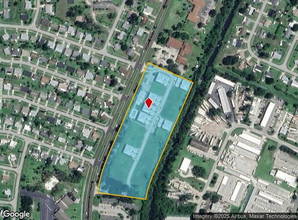
Property Record
4520 S Biscayne Dr, North Port, FL 34287
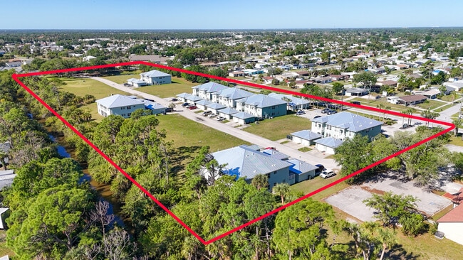
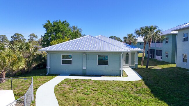

This Property Is For Sale
NEARBY LISTINGS FOR SALE OR LEASE
-
-
View all North Port listings for sale on LoopNet.com
Property Detail
4520 S Biscayne Dr
North Port-Sarasota-Bradenton, FL
Port Charlotte Sub 43
0996-00-2904
LOT 1, 2, 3, 4, 5, 6 & 7, LESS S 39.35 FT OF LOT 7, TOGETHER WITH VACATED 30 FT DRAINAGE R/W BETWEEN LOTS 3 & 4, BLK 29, PORT CHARLOTTE SUB
Multifamilydwelling
Sarasota
AE
Florida
12115C0386G
1,2,7
2024
7.78 AC
2025
North Port
002739
Tampa/St Petersburg
22,540 SF
DEMOGRAPHICS near 4520 S Biscayne Dr
1 Mile
3 Mile
5 Mile
2024 Total Population
7,228
33,133
63,396
2029 Population
8,239
38,022
73,015
Pop Growth 2024-2029
+ 13.99%
+ 14.76%
+ 15.17%
Average Age
44
50
47
2024 Total Households
3,074
14,733
26,237
HH Growth 2024-2029
+ 13.89%
+ 14.84%
+ 15.29%
Median Household Inc
$47,971
$57,617
$63,287
Avg Household Size
2.30
2.20
2.40
2024 Avg HH Vehicles
2.00
2.00
2.00
Median Home Value
$198,526
$202,985
$237,523
Median Year Built
1977
1989
2000
Nearby Places
Map Layers
Map Styles
 Street
 Aerial
- Restaurants
- Banks
- Shops
- Fitness
- Groceries
PUBLIC TRANSPORTATION
AIRPORT
Punta Gorda
DRIVE
WALK
Distance
Punta Gorda
36 min
19.9 mi
Freight Ports
Port Manatee
DRIVE
WALK
Distance
Port Manatee
68 min
52.8 mi
Nearby Properties
Address
Land Use
TOTAL SIZE
Lot Size
Zoning
Address
Land Use
TOTAL SIZE
Lot Size
Zoning
548,781 SF
196.98 AC
GU
Address
Land Use
TOTAL SIZE
Lot Size
Zoning
218,356 SF
17.14 AC
AC2
Address
Land Use
TOTAL SIZE
Lot Size
Zoning
267,412 SF
23.26 AC
AC1
Address
Land Use
TOTAL SIZE
Lot Size
Zoning
146,932 SF
39.48 AC
AC2
Address
Land Use
TOTAL SIZE
Lot Size
Zoning
302,632 SF
15.71 AC
AC2
Address
Land Use
TOTAL SIZE
Lot Size
Zoning
205,624 SF
21.37 AC
AC1
Address
Land Use
TOTAL SIZE
Lot Size
Zoning
103,327 SF
47.54 AC
GU
Address
Land Use
TOTAL SIZE
Lot Size
Zoning
101,676 SF
8.83 AC
AC1
Address
Land Use
TOTAL SIZE
Lot Size
Zoning
79,944 SF
15.64 AC
AC1
Address
Land Use
TOTAL SIZE
Lot Size
Zoning
155,080 SF
8.96 AC
CG
Address
Land Use
TOTAL SIZE
Lot Size
Zoning
196,163 SF
15.60 AC
AC1
Address
Land Use
TOTAL SIZE
Lot Size
Zoning
142,364 SF
13.87 AC
AC1
Address
Land Use
TOTAL SIZE
Lot Size
Zoning
40,161 SF
40 AC
GU
Address
Land Use
TOTAL SIZE
Lot Size
Zoning
65,103 SF
10.16 AC
AC2
Address
Land Use
TOTAL SIZE
Lot Size
Zoning
18.49 AC
PCDN
Address
Land Use
TOTAL SIZE
Lot Size
Zoning
85,529 SF
11.41 AC
AC1
Address
Land Use
TOTAL SIZE
Lot Size
Zoning
105,046 SF
12.69 AC
AC1
Address
Land Use
TOTAL SIZE
Lot Size
Zoning
115,678 SF
8.58 AC
R3
Address
Land Use
TOTAL SIZE
Lot Size
Zoning
42,923 SF
403.06 AC
R1
Address
Land Use
TOTAL SIZE
Lot Size
Zoning
63,016 SF
2.56 AC
AC1
Address
Land Use
TOTAL SIZE
Lot Size
Zoning
14,714 SF
81.28 AC
AC7B
Address
Land Use
TOTAL SIZE
Lot Size
Zoning
43,387 SF
5.09 AC
AC2
Address
Land Use
TOTAL SIZE
Lot Size
Zoning
289,861 SF
27.47 AC
AC2
Address
Land Use
TOTAL SIZE
Lot Size
Zoning
19,816 SF
2.70 AC
AC2
Address
Land Use
TOTAL SIZE
Lot Size
Zoning
17.48 AC
AC1
Address
Land Use
TOTAL SIZE
Lot Size
Zoning
55,685 SF
6.15 AC
COR
Address
Land Use
TOTAL SIZE
Lot Size
Zoning
41,054 SF
5.66 AC
CNP
Address
Land Use
TOTAL SIZE
Lot Size
Zoning
54.56 AC
AC1
Address
Land Use
TOTAL SIZE
Lot Size
Zoning
50,032 SF
10.06 AC
AC1
The World's #1 Commercial Real Estate Marketplace
Connect with us
© 2026 CoStar Group
The information above has been obtained from sources believed reliable. While we do not doubt its accuracy we have not verified it and make no guarantee, warranty or representation about it. It is your responsibility to independently confirm its accuracy and completeness. Any projections, opinions, assumptions, or estimates used are for example only and do not represent the current or future performance of the property. The value of this transaction to you depends on tax and other factors which should be evaluated by your tax, financial, and legal advisors. You and your advisors should conduct a careful, independent investigation of the property to determine to your satisfaction the suitability of the property for your needs.