Property Record
4521 W Bay Blvd, Estero, FL 33928
NEARBY LISTINGS FOR SALE OR LEASE
Property Detail
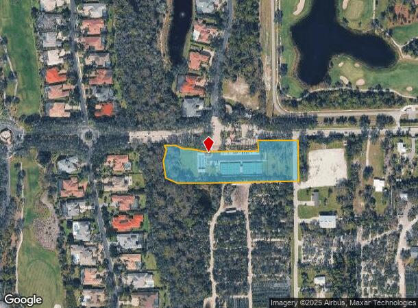
4521 W Bay Blvd
Cape Coral-Fort Myers, FL
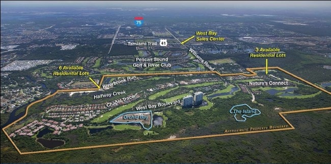
West Bay Club
05-47-25-E1-07000.001A
WEST BAY CLUB PB 62 PGS 79-111 LOT 1A LESS E 30 FT
Parkplaygroundpicnicarea
Lee
AE
Florida
12071C0587G
1a
2024
2.78 AC
2025
Estero
050210
Southwest Florida
240 SF
DEMOGRAPHICS near 4521 W Bay Blvd
1 Mile
3 Mile
5 Mile
2024 Total Population
3,116
29,376
93,065
2029 Population
3,803
35,413
111,976
Pop Growth 2024-2029
+ 22.05%
+ 20.55%
+ 20.32%
Average Age
62
59
53
2024 Total Households
1,544
14,721
43,501
HH Growth 2024-2029
+ 21.70%
+ 20.32%
+ 20.41%
Median Household Inc
$90,785
$86,819
$84,556
Avg Household Size
2.00
1.90
2.10
2024 Avg HH Vehicles
2.00
2.00
2.00
Median Home Value
$444,707
$369,706
$372,100
Median Year Built
2003
2000
1998
Nearby Places
Map Layers
Map Styles
 Street
 Aerial
- Restaurants
- Banks
- Shops
- Fitness
- Groceries
PUBLIC TRANSPORTATION
AIRPORT
Southwest Florida International
DRIVE
WALK
Distance
Southwest Florida International
24 min
15.3 mi
Freight Ports
Port Manatee
DRIVE
WALK
Distance
Port Manatee
133 min
115.0 mi
Nearby Properties
Address
Land Use
TOTAL SIZE
Lot Size
Zoning
Address
Land Use
TOTAL SIZE
Lot Size
Zoning
785,522 SF
70.04 AC
MPD
Address
Land Use
TOTAL SIZE
Lot Size
Zoning
177,930 SF
20.74 AC
MPD
Address
Land Use
TOTAL SIZE
Lot Size
Zoning
687,668 SF
27.19 AC
CPD
Address
Land Use
TOTAL SIZE
Lot Size
Zoning
20.19 AC
MPD
Address
Land Use
TOTAL SIZE
Lot Size
Zoning
540,648 SF
19.75 AC
MPD
Address
Land Use
TOTAL SIZE
Lot Size
Zoning
293,332 SF
7.03 AC
CPD
Address
Land Use
TOTAL SIZE
Lot Size
Zoning
245,356 SF
12.54 AC
MPD
Address
Land Use
TOTAL SIZE
Lot Size
Zoning
274,691 SF
6.62 AC
MPD
Address
Land Use
TOTAL SIZE
Lot Size
Zoning
348,757 SF
69.01 AC
CF-2
Address
Land Use
TOTAL SIZE
Lot Size
Zoning
Address
Land Use
TOTAL SIZE
Lot Size
Zoning
69.37 AC
RPD
Address
Land Use
TOTAL SIZE
Lot Size
Zoning
5.39 AC
RPD
Address
Land Use
TOTAL SIZE
Lot Size
Zoning
239.40 AC
Address
Land Use
TOTAL SIZE
Lot Size
Zoning
48,538 SF
4.46 AC
CC
Address
Land Use
TOTAL SIZE
Lot Size
Zoning
181,680 SF
9.89 AC
MPD
Address
Land Use
TOTAL SIZE
Lot Size
Zoning
35,085 SF
1.70 AC
TFC2
Address
Land Use
TOTAL SIZE
Lot Size
Zoning
103,495 SF
13.29 AC
CPD
Address
Land Use
TOTAL SIZE
Lot Size
Zoning
89,049 SF
11.59 AC
CPD
Address
Land Use
TOTAL SIZE
Lot Size
Zoning
206,959 SF
29.59 AC
MPD
Address
Land Use
TOTAL SIZE
Lot Size
Zoning
97,737 SF
10.67 AC
CPD
Address
Land Use
TOTAL SIZE
Lot Size
Zoning
154.77 AC
RPD
Address
Land Use
TOTAL SIZE
Lot Size
Zoning
67,650 SF
2.27 AC
MPD
Address
Land Use
TOTAL SIZE
Lot Size
Zoning
73,370 SF
2.42 AC
MPD
Address
Land Use
TOTAL SIZE
Lot Size
Zoning
84,782 SF
8.30 AC
MPD
Address
Land Use
TOTAL SIZE
Lot Size
Zoning
Address
Land Use
TOTAL SIZE
Lot Size
Zoning
94,995 SF
8.67 AC
CPD
Address
Land Use
TOTAL SIZE
Lot Size
Zoning
122,309 SF
1.95 AC
MPD
Address
Land Use
TOTAL SIZE
Lot Size
Zoning
192,281 SF
13.86 AC
MPD
Address
Land Use
TOTAL SIZE
Lot Size
Zoning
50,952 SF
10.22 AC
CPD
Address
Land Use
TOTAL SIZE
Lot Size
Zoning
69,218 SF
7.23 AC
CPD
The World's #1 Commercial Real Estate Marketplace
Connect with us
© 2025 CoStar Group
The information above has been obtained from sources believed reliable. While we do not doubt its accuracy we have not verified it and make no guarantee, warranty or representation about it. It is your responsibility to independently confirm its accuracy and completeness. Any projections, opinions, assumptions, or estimates used are for example only and do not represent the current or future performance of the property. The value of this transaction to you depends on tax and other factors which should be evaluated by your tax, financial, and legal advisors. You and your advisors should conduct a careful, independent investigation of the property to determine to your satisfaction the suitability of the property for your needs.