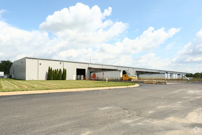
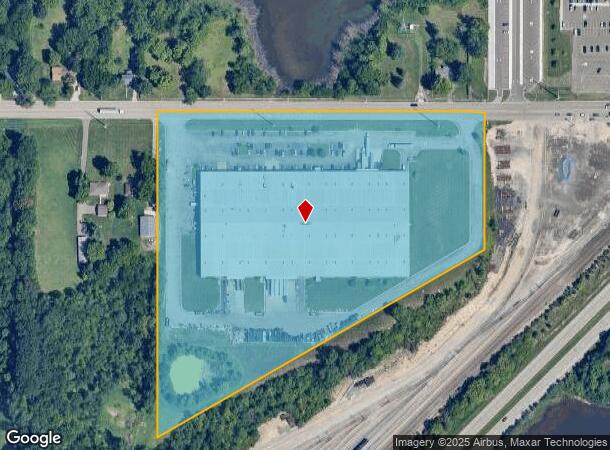
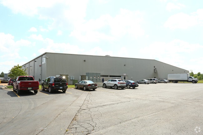
Property Record
4521 W Mount Hope Hwy, Lansing, MI 48917
NEARBY LISTINGS FOR SALE OR LEASE
Property Detail
4521 W Mount Hope Hwy
040-025-100-092-00
COM AT N 1/4 POST FOR POB, S 394.32 FT, S 60 DEG 20 MIN W 1076.73 FT, N 939.59 FT TO N SEC LINE, E 940 FT TO BEG. SEC 25, T4N,R3W, DELTA TWP 1997
Warehouse
Eaton
X
Michigan
26065C0128D
15 AC
2024
Southern Lansing
2025
West Michigan
020202
Lansing-East Lansing, MI
180,000 SF
DEMOGRAPHICS near 4521 W Mount Hope Hwy
1 Mile
3 Mile
5 Mile
2024 Total Population
3,829
57,919
140,643
2029 Population
3,806
57,650
140,363
Pop Growth 2024-2029
(0.60%)
(0.46%)
(0.20%)
Average Age
43
40
39
2024 Total Households
1,696
25,372
61,186
HH Growth 2024-2029
(0.59%)
(0.54%)
(0.27%)
Median Household Inc
$52,748
$52,877
$53,342
Avg Household Size
2.20
2.20
2.20
2024 Avg HH Vehicles
2.00
2.00
2.00
Median Home Value
$163,450
$142,332
$137,277
Median Year Built
1973
1966
1964
Nearby Places
Map Layers
Map Styles
 Street
 Aerial
- Restaurants
- Banks
- Shops
- Fitness
- Groceries
PUBLIC TRANSPORTATION
COMMUTER RAIL
DRIVE
WALK
Distance
12 min
7.0 mi
AIRPORT
Capital Region International
DRIVE
WALK
Distance
Capital Region International
12 min
5.9 mi
Nearby Properties
Address
Land Use
TOTAL SIZE
Lot Size
Zoning
Address
Land Use
TOTAL SIZE
Lot Size
Zoning
1,085,633 SF
115.14 AC
NONE
Address
Land Use
TOTAL SIZE
Lot Size
Zoning
628,230 SF
38.20 AC
NONE
Address
Land Use
TOTAL SIZE
Lot Size
Zoning
69,851 SF
134.23 AC
I HVY
Address
Land Use
TOTAL SIZE
Lot Size
Zoning
166,083 SF
39.98 AC
NONE
Address
Land Use
TOTAL SIZE
Lot Size
Zoning
170,860 SF
16.35 AC
NONE
Address
Land Use
TOTAL SIZE
Lot Size
Zoning
217,664 SF
61.37 AC
NONE
Address
Land Use
TOTAL SIZE
Lot Size
Zoning
286.23 AC
NONE
Address
Land Use
TOTAL SIZE
Lot Size
Zoning
389,485 SF
30.04 AC
NONE
Address
Land Use
TOTAL SIZE
Lot Size
Zoning
1,059,295 SF
139.28 AC
NONE
Address
Land Use
TOTAL SIZE
Lot Size
Zoning
198,225 SF
11.54 AC
NONE
Address
Land Use
TOTAL SIZE
Lot Size
Zoning
111,804 SF
80 AC
NONE
Address
Land Use
TOTAL SIZE
Lot Size
Zoning
436,698 SF
48.16 AC
NONE
Address
Land Use
TOTAL SIZE
Lot Size
Zoning
628,651 SF
34.29 AC
NONE
Address
Land Use
TOTAL SIZE
Lot Size
Zoning
2,276,790 SF
96.93 AC
NONE
Address
Land Use
TOTAL SIZE
Lot Size
Zoning
231,000 SF
26 AC
Address
Land Use
TOTAL SIZE
Lot Size
Zoning
292,918 SF
I-FAC
Address
Land Use
TOTAL SIZE
Lot Size
Zoning
113.83 AC
NONE
Address
Land Use
TOTAL SIZE
Lot Size
Zoning
235,893 SF
18.69 AC
NONE
Address
Land Use
TOTAL SIZE
Lot Size
Zoning
824,570 SF
47.65 AC
NONE
Address
Land Use
TOTAL SIZE
Lot Size
Zoning
144,630 SF
11.51 AC
M-1
Address
Land Use
TOTAL SIZE
Lot Size
Zoning
189,157 SF
15.55 AC
NONE
Address
Land Use
TOTAL SIZE
Lot Size
Zoning
219,176 SF
9.45 AC
NONE
Address
Land Use
TOTAL SIZE
Lot Size
Zoning
14,505 SF
90 AC
Address
Land Use
TOTAL SIZE
Lot Size
Zoning
50,364 SF
25.57 AC
M-1
Address
Land Use
TOTAL SIZE
Lot Size
Zoning
106,344 SF
10.69 AC
NONE
Address
Land Use
TOTAL SIZE
Lot Size
Zoning
179,316 SF
16.68 AC
NONE
Address
Land Use
TOTAL SIZE
Lot Size
Zoning
250,100 SF
25.45 AC
NONE
Address
Land Use
TOTAL SIZE
Lot Size
Zoning
404,215 SF
40 AC
NONE
Address
Land Use
TOTAL SIZE
Lot Size
Zoning
160,000 SF
16.18 AC
Address
Land Use
TOTAL SIZE
Lot Size
Zoning
269,800 SF
20.10 AC
NONE
The World's #1 Commercial Real Estate Marketplace
Connect with us
© 2025 CoStar Group
The information above has been obtained from sources believed reliable. While we do not doubt its accuracy we have not verified it and make no guarantee, warranty or representation about it. It is your responsibility to independently confirm its accuracy and completeness. Any projections, opinions, assumptions, or estimates used are for example only and do not represent the current or future performance of the property. The value of this transaction to you depends on tax and other factors which should be evaluated by your tax, financial, and legal advisors. You and your advisors should conduct a careful, independent investigation of the property to determine to your satisfaction the suitability of the property for your needs.