Property Record
4528 Walpole Rd, High Point, NC 27265

This Property Is For Sale
NEARBY LISTINGS FOR SALE OR LEASE
Property Detail
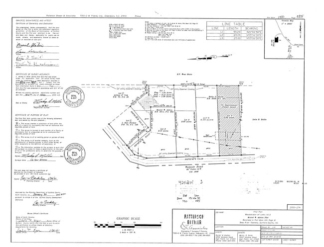
4528 Walpole Rd
Greensboro-High Point, NC
Muriel W Alston
0171230
2.00AC 4 PB 140-85 PL:140-85
Residentialnec
Guilford
X
North Carolina
3710780400J
45
2024
2 AC
2025
Airport/W Guilford County
016204
Greensboro/Winston-Salem
DEMOGRAPHICS near 4528 Walpole Rd
1 Mile
3 Mile
5 Mile
2024 Total Population
5,071
29,443
79,419
2029 Population
5,313
30,420
82,031
Pop Growth 2024-2029
+ 4.77%
+ 3.32%
+ 3.29%
Average Age
38
41
41
2024 Total Households
1,658
11,895
33,964
HH Growth 2024-2029
+ 4.95%
+ 3.47%
+ 3.48%
Median Household Inc
$128,689
$94,282
$75,024
Avg Household Size
3.00
2.40
2.30
2024 Avg HH Vehicles
2.00
2.00
2.00
Median Home Value
$351,764
$305,356
$278,739
Median Year Built
2005
2001
1996
Nearby Places
Map Layers
Map Styles
 Street
 Aerial
- Restaurants
- Banks
- Shops
- Fitness
- Groceries
PUBLIC TRANSPORTATION
COMMUTER RAIL
High Point Station (Piedmont - North Carolina by Train (NC Train))
DRIVE
WALK
Distance
High Point Station (Piedmont - North Carolina by Train (NC Train))
18 min
9.3 mi
AIRPORT
Piedmont Triad International
DRIVE
WALK
Distance
Piedmont Triad International
21 min
7.7 mi
Freight Ports
Virginia Port Authority - Richmond
DRIVE
WALK
Distance
Virginia Port Authority - Richmond
247 min
210.9 mi
Nearby Properties
Address
Land Use
TOTAL SIZE
Lot Size
Zoning
Address
Land Use
TOTAL SIZE
Lot Size
Zoning
37,237 SF
334.45 AC
HI
Address
Land Use
TOTAL SIZE
Lot Size
Zoning
1,057,283 SF
104.31 AC
PDP
Address
Land Use
TOTAL SIZE
Lot Size
Zoning
256,051 SF
37.69 AC
LI
Address
Land Use
TOTAL SIZE
Lot Size
Zoning
181,444 SF
126.42 AC
PD-P
Address
Land Use
TOTAL SIZE
Lot Size
Zoning
691,408 SF
58.69 AC
LI
Address
Land Use
TOTAL SIZE
Lot Size
Zoning
186,200 SF
10.58 AC
LI
Address
Land Use
TOTAL SIZE
Lot Size
Zoning
342,765 SF
20.98 AC
PUD
Address
Land Use
TOTAL SIZE
Lot Size
Zoning
509,216 SF
40.85 AC
LI
Address
Land Use
TOTAL SIZE
Lot Size
Zoning
400,000 SF
46.72 AC
LI
Address
Land Use
TOTAL SIZE
Lot Size
Zoning
229,103 SF
18.76 AC
CZ-I
Address
Land Use
TOTAL SIZE
Lot Size
Zoning
291,895 SF
21.52 AC
RM-26
Address
Land Use
TOTAL SIZE
Lot Size
Zoning
363,308 SF
29.41 AC
RM-16
Address
Land Use
TOTAL SIZE
Lot Size
Zoning
309,749 SF
16.74 AC
CZ-PDM
Address
Land Use
TOTAL SIZE
Lot Size
Zoning
362,708 SF
56.81 AC
LI
Address
Land Use
TOTAL SIZE
Lot Size
Zoning
53,362 SF
0.51 AC
LAR3
Address
Land Use
TOTAL SIZE
Lot Size
Zoning
274,999 SF
21.57 AC
LI
Address
Land Use
TOTAL SIZE
Lot Size
Zoning
214,941 SF
13.29 AC
PDR
Address
Land Use
TOTAL SIZE
Lot Size
Zoning
299,786 SF
24.49 AC
PDP
Address
Land Use
TOTAL SIZE
Lot Size
Zoning
227,652 SF
21.64 AC
LI
Address
Land Use
TOTAL SIZE
Lot Size
Zoning
240,936 SF
12.02 AC
PDM
Address
Land Use
TOTAL SIZE
Lot Size
Zoning
269,956 SF
19.44 AC
OI
Address
Land Use
TOTAL SIZE
Lot Size
Zoning
209,184 SF
13.52 AC
OI
Address
Land Use
TOTAL SIZE
Lot Size
Zoning
161,975 SF
20.66 AC
BP
Address
Land Use
TOTAL SIZE
Lot Size
Zoning
75,588 SF
6.49 AC
LI
Address
Land Use
TOTAL SIZE
Lot Size
Zoning
760,545 SF
69.50 AC
LI
Address
Land Use
TOTAL SIZE
Lot Size
Zoning
176,000 SF
12.95 AC
CZ-I
Address
Land Use
TOTAL SIZE
Lot Size
Zoning
304,447 SF
27.69 AC
RM-16
Address
Land Use
TOTAL SIZE
Lot Size
Zoning
342,988 SF
29.36 AC
LI
Address
Land Use
TOTAL SIZE
Lot Size
Zoning
128,435 SF
10.40 AC
LI
Address
Land Use
TOTAL SIZE
Lot Size
Zoning
361,412 SF
35.81 AC
LI
The World's #1 Commercial Real Estate Marketplace
Connect with us
© 2026 CoStar Group
The information above has been obtained from sources believed reliable. While we do not doubt its accuracy we have not verified it and make no guarantee, warranty or representation about it. It is your responsibility to independently confirm its accuracy and completeness. Any projections, opinions, assumptions, or estimates used are for example only and do not represent the current or future performance of the property. The value of this transaction to you depends on tax and other factors which should be evaluated by your tax, financial, and legal advisors. You and your advisors should conduct a careful, independent investigation of the property to determine to your satisfaction the suitability of the property for your needs.