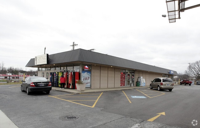
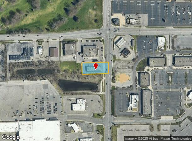
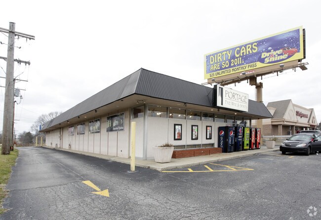
Property Record
4527 Miami St, South Bend, IN 46614
NEARBY LISTINGS FOR SALE OR LEASE
-
-
View all South Bend listings for lease on LoopNet.com
Property Detail
4527 Miami St
71-08-25-426-010.000-002
100 X 250 BEG. 250 S OF NE COR SE .573 AC. SEC.25-37-2E
Storebuilding
St Joseph
X
Indiana
18141C0213D
0.57 AC
2023
Greater South Bend
2024
South Bend/Mishawaka
011804
South Bend-Mishawaka, IN-MI
5,080 SF
DEMOGRAPHICS near 4527 Miami St
1 Mile
3 Mile
5 Mile
2024 Total Population
7,386
48,717
137,221
2029 Population
7,271
48,617
137,768
Pop Growth 2024-2029
(1.56%)
(0.21%)
+ 0.40%
Average Age
42
39
37
2024 Total Households
3,240
19,580
54,514
HH Growth 2024-2029
(1.64%)
(0.32%)
+ 0.40%
Median Household Inc
$65,006
$54,496
$49,967
Avg Household Size
2.20
2.40
2.30
2024 Avg HH Vehicles
2.00
2.00
2.00
Median Home Value
$143,868
$131,852
$127,912
Median Year Built
1963
1958
1957
Nearby Places
Map Layers
Map Styles
 Street
 Aerial
- Restaurants
- Banks
- Shops
- Fitness
- Groceries
PUBLIC TRANSPORTATION
COMMUTER RAIL
DRIVE
WALK
Distance
16 min
7.3 mi
South Bend Airport Station (South Shore Line - Northern Indiana Commuter Transportation District (South Shore Line))
DRIVE
WALK
Distance
South Bend Airport Station (South Shore Line - Northern Indiana Commuter Transportation District (South Shore Line))
20 min
9.6 mi
AIRPORT
South Bend International
DRIVE
WALK
Distance
South Bend International
27 min
10.5 mi
SALE & LEASE HISTORY
LISTING DATE
SALE/LEASE

Feb 15, 2018
For Lease
Nearby Properties
Address
Land Use
TOTAL SIZE
Lot Size
Zoning
Address
Land Use
TOTAL SIZE
Lot Size
Zoning
270,484 SF
131 SF
Address
Land Use
TOTAL SIZE
Lot Size
Zoning
338,816 SF
33.65 AC
Address
Land Use
TOTAL SIZE
Lot Size
Zoning
283,481 SF
51.29 AC
Address
Land Use
TOTAL SIZE
Lot Size
Zoning
231,450 SF
87 SF
Address
Land Use
TOTAL SIZE
Lot Size
Zoning
194,931 SF
44 SF
Address
Land Use
TOTAL SIZE
Lot Size
Zoning
112,424 SF
5 AC
Address
Land Use
TOTAL SIZE
Lot Size
Zoning
25,228 SF
68.61 AC
Address
Land Use
TOTAL SIZE
Lot Size
Zoning
221,887 SF
87 SF
Address
Land Use
TOTAL SIZE
Lot Size
Zoning
353.40 AC
Address
Land Use
TOTAL SIZE
Lot Size
Zoning
174,526 SF
24.37 AC
Address
Land Use
TOTAL SIZE
Lot Size
Zoning
633,136 SF
2.59 AC
Address
Land Use
TOTAL SIZE
Lot Size
Zoning
100,191 SF
11.72 AC
Address
Land Use
TOTAL SIZE
Lot Size
Zoning
74,976 SF
44 SF
Address
Land Use
TOTAL SIZE
Lot Size
Zoning
177,518 SF
35.64 AC
Address
Land Use
TOTAL SIZE
Lot Size
Zoning
91,091 SF
131 SF
Address
Land Use
TOTAL SIZE
Lot Size
Zoning
136,568 SF
44 SF
Address
Land Use
TOTAL SIZE
Lot Size
Zoning
79,760 SF
13.17 AC
Address
Land Use
TOTAL SIZE
Lot Size
Zoning
79,911 SF
18.98 AC
Address
Land Use
TOTAL SIZE
Lot Size
Zoning
123,359 SF
44 SF
Address
Land Use
TOTAL SIZE
Lot Size
Zoning
87,310 SF
44 SF
Address
Land Use
TOTAL SIZE
Lot Size
Zoning
93,530 SF
8.08 AC
Address
Land Use
TOTAL SIZE
Lot Size
Zoning
15,436 SF
174 SF
Address
Land Use
TOTAL SIZE
Lot Size
Zoning
62,834 SF
87 SF
Address
Land Use
TOTAL SIZE
Lot Size
Zoning
179,328 SF
2.07 AC
Address
Land Use
TOTAL SIZE
Lot Size
Zoning
158,495 SF
12.23 AC
Address
Land Use
TOTAL SIZE
Lot Size
Zoning
4,464 SF
131 SF
Address
Land Use
TOTAL SIZE
Lot Size
Zoning
52,648 SF
2.80 AC
Address
Land Use
TOTAL SIZE
Lot Size
Zoning
93,376 SF
23.93 AC
Address
Land Use
TOTAL SIZE
Lot Size
Zoning
46,060 SF
3.89 AC
Address
Land Use
TOTAL SIZE
Lot Size
Zoning
48,204 SF
44 SF
The World's #1 Commercial Real Estate Marketplace
Connect with us
© 2025 CoStar Group
The information above has been obtained from sources believed reliable. While we do not doubt its accuracy we have not verified it and make no guarantee, warranty or representation about it. It is your responsibility to independently confirm its accuracy and completeness. Any projections, opinions, assumptions, or estimates used are for example only and do not represent the current or future performance of the property. The value of this transaction to you depends on tax and other factors which should be evaluated by your tax, financial, and legal advisors. You and your advisors should conduct a careful, independent investigation of the property to determine to your satisfaction the suitability of the property for your needs.