Property Record
4527 Ogburn Ave, Winston Salem, NC 27105
NEARBY LISTINGS FOR SALE OR LEASE
-
-
View all Winston Salem listings for sale on LoopNet.com
Property Detail
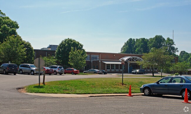
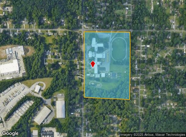
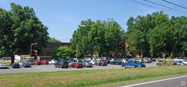
4527 Ogburn Ave
Winston-Salem, NC
Mineral Sprg
6837-57-4964
MINERAL SPRG ELEM&MIDDLE LO:401 BL:2998 BU:1
Recreationalentertainmentgeneral
Forsyth
X
North Carolina
3710683700J
401
0
30.14 AC
2025
NE Forsyth County
001500
Greensboro/Winston-Salem
13,664 SF
DEMOGRAPHICS near 4527 Ogburn Ave
1 Mile
3 Mile
5 Mile
2024 Total Population
5,126
45,900
110,479
2029 Population
5,382
48,021
115,592
Pop Growth 2024-2029
+ 4.99%
+ 4.62%
+ 4.63%
Average Age
36
36
38
2024 Total Households
1,779
16,904
45,474
HH Growth 2024-2029
+ 5.00%
+ 4.83%
+ 4.79%
Median Household Inc
$40,969
$37,087
$46,196
Avg Household Size
2.80
2.40
2.20
2024 Avg HH Vehicles
2.00
2.00
2.00
Median Home Value
$118,597
$120,484
$174,506
Median Year Built
1973
1973
1975
Nearby Places
Map Layers
Map Styles
 Street
 Aerial
- Restaurants
- Banks
- Shops
- Fitness
- Groceries
PUBLIC TRANSPORTATION
AIRPORT
Piedmont Triad International
DRIVE
WALK
Distance
Piedmont Triad International
39 min
24.2 mi
Freight Ports
Virginia Port Authority - Richmond
DRIVE
WALK
Distance
Virginia Port Authority - Richmond
266 min
227.8 mi
Nearby Properties
Address
Land Use
TOTAL SIZE
Lot Size
Zoning
Address
Land Use
TOTAL SIZE
Lot Size
Zoning
100 SF
213.71 AC
C
Address
Land Use
TOTAL SIZE
Lot Size
Zoning
412,075 SF
94.76 AC
CPO,GI,RS9
Address
Land Use
TOTAL SIZE
Lot Size
Zoning
329,963 SF
58.84 AC
RM18-S
Address
Land Use
TOTAL SIZE
Lot Size
Zoning
283,831 SF
559.85 AC
GI,RS9
Address
Land Use
TOTAL SIZE
Lot Size
Zoning
122,900 SF
49.54 AC
GB
Address
Land Use
TOTAL SIZE
Lot Size
Zoning
153,937 SF
34.63 AC
RM12-S
Address
Land Use
TOTAL SIZE
Lot Size
Zoning
264,904 SF
21.63 AC
GB
Address
Land Use
TOTAL SIZE
Lot Size
Zoning
169,443 SF
33.02 AC
GB
Address
Land Use
TOTAL SIZE
Lot Size
Zoning
245,828 SF
28.02 AC
GB
Address
Land Use
TOTAL SIZE
Lot Size
Zoning
449,945 SF
20.96 AC
LI
Address
Land Use
TOTAL SIZE
Lot Size
Zoning
152,968 SF
32.40 AC
RM18
Address
Land Use
TOTAL SIZE
Lot Size
Zoning
127,566 SF
35.86 AC
C-L
Address
Land Use
TOTAL SIZE
Lot Size
Zoning
373,394 SF
37.51 AC
GI
Address
Land Use
TOTAL SIZE
Lot Size
Zoning
119,130 SF
5.84 AC
GB-L
Address
Land Use
TOTAL SIZE
Lot Size
Zoning
85,354 SF
29.13 AC
RM18-S
Address
Land Use
TOTAL SIZE
Lot Size
Zoning
178,192 SF
28.15 AC
RM18
Address
Land Use
TOTAL SIZE
Lot Size
Zoning
185,506 SF
57.30 AC
GB
Address
Land Use
TOTAL SIZE
Lot Size
Zoning
91,905 SF
21.18 AC
RM18-S
Address
Land Use
TOTAL SIZE
Lot Size
Zoning
106,821 SF
14.95 AC
RM12-S
Address
Land Use
TOTAL SIZE
Lot Size
Zoning
224,895 SF
31.67 AC
HB-S
Address
Land Use
TOTAL SIZE
Lot Size
Zoning
111,133 SF
10.09 AC
RM8-S
Address
Land Use
TOTAL SIZE
Lot Size
Zoning
12,132 SF
57.50 AC
RM18
Address
Land Use
TOTAL SIZE
Lot Size
Zoning
120,256 SF
43.62 AC
GB-S,IP
Address
Land Use
TOTAL SIZE
Lot Size
Zoning
90,740 SF
17.28 AC
RM18
Address
Land Use
TOTAL SIZE
Lot Size
Zoning
106,941 SF
10.91 AC
RM12-S
Address
Land Use
TOTAL SIZE
Lot Size
Zoning
26,858 SF
4.79 AC
GB-S
Address
Land Use
TOTAL SIZE
Lot Size
Zoning
514,721 SF
44.90 AC
GI,LI
Address
Land Use
TOTAL SIZE
Lot Size
Zoning
198,626 SF
31 AC
GI
Address
Land Use
TOTAL SIZE
Lot Size
Zoning
509,275 SF
25.58 AC
LI
Address
Land Use
TOTAL SIZE
Lot Size
Zoning
34,316 SF
6.50 AC
GB
The World's #1 Commercial Real Estate Marketplace
Connect with us
© 2026 CoStar Group
The information above has been obtained from sources believed reliable. While we do not doubt its accuracy we have not verified it and make no guarantee, warranty or representation about it. It is your responsibility to independently confirm its accuracy and completeness. Any projections, opinions, assumptions, or estimates used are for example only and do not represent the current or future performance of the property. The value of this transaction to you depends on tax and other factors which should be evaluated by your tax, financial, and legal advisors. You and your advisors should conduct a careful, independent investigation of the property to determine to your satisfaction the suitability of the property for your needs.