Property Record
4527 Sunbeam Rd, Jacksonville, FL 32257


NEARBY LISTINGS FOR SALE OR LEASE
Property Detail
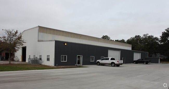
4527 Sunbeam Rd
148682-0150
Section Land
Warehouse
28-3S-27E 3.404 SW1/4 OF SE1/4 PT RECD O/R 18300-1300
X
Duval
12031C0553J
Florida
2024
3.46 AC
2025
Mandarin
016725
Jacksonville (Florida)
20,667 SF
Jacksonville, FL
DEMOGRAPHICS near 4527 Sunbeam Rd
1 Mile
3 Mile
5 Mile
2024 Total Population
14,016
73,163
165,333
2029 Population
14,780
76,769
173,144
Pop Growth 2024-2029
+ 5.45%
+ 4.93%
+ 4.72%
Average Age
39
40
40
2024 Total Households
5,845
31,899
70,550
HH Growth 2024-2029
+ 5.39%
+ 5.15%
+ 4.89%
Median Household Inc
$59,071
$62,460
$69,321
Avg Household Size
2.30
2.20
2.30
2024 Avg HH Vehicles
2.00
2.00
2.00
Median Home Value
$282,598
$263,358
$286,068
Median Year Built
1988
1984
1988
Nearby Places
Map Layers
Map Styles
 Street
 Aerial
- Restaurants
- Banks
- Shops
- Fitness
- Groceries
PUBLIC TRANSPORTATION
AIRPORT
Jacksonville International
DRIVE
WALK
Distance
Jacksonville International
43 min
27.5 mi
Freight Ports
Jacksonville Port
DRIVE
WALK
Distance
Jacksonville Port
27 min
16.0 mi
Nearby Properties
Address
Land Use
TOTAL SIZE
Lot Size
Zoning
Address
Land Use
TOTAL SIZE
Lot Size
Zoning
1,159,855 SF
89.44 AC
RMD-D
Address
Land Use
TOTAL SIZE
Lot Size
Zoning
723,629 SF
18.30 AC
PUD
Address
Land Use
TOTAL SIZE
Lot Size
Zoning
446,326 SF
23.68 AC
RMD-D
Address
Land Use
TOTAL SIZE
Lot Size
Zoning
358,537 SF
29.16 AC
RMD-C
Address
Land Use
TOTAL SIZE
Lot Size
Zoning
287,406 SF
32.10 AC
CCG-1
Address
Land Use
TOTAL SIZE
Lot Size
Zoning
266,087 SF
35.07 AC
RMD-D
Address
Land Use
TOTAL SIZE
Lot Size
Zoning
193,941 SF
7.35 AC
PUD
Address
Land Use
TOTAL SIZE
Lot Size
Zoning
325,620 SF
17.76 AC
PUD
Address
Land Use
TOTAL SIZE
Lot Size
Zoning
307,396 SF
24.45 AC
PUD
Address
Land Use
TOTAL SIZE
Lot Size
Zoning
304,017 SF
20.58 AC
RMD-D
Address
Land Use
TOTAL SIZE
Lot Size
Zoning
365,629 SF
23.23 AC
RMD-D
Address
Land Use
TOTAL SIZE
Lot Size
Zoning
348,919 SF
18.08 AC
RMD-D
Address
Land Use
TOTAL SIZE
Lot Size
Zoning
330,037 SF
28.33 AC
RMD-C
Address
Land Use
TOTAL SIZE
Lot Size
Zoning
291,833 SF
16.91 AC
CRO
Address
Land Use
TOTAL SIZE
Lot Size
Zoning
313,009 SF
22.50 AC
RMD-D
Address
Land Use
TOTAL SIZE
Lot Size
Zoning
236,068 SF
18.87 AC
PUD
Address
Land Use
TOTAL SIZE
Lot Size
Zoning
404,315 SF
19.27 AC
RMD-D
Address
Land Use
TOTAL SIZE
Lot Size
Zoning
310,983 SF
16.16 AC
RMD-C
Address
Land Use
TOTAL SIZE
Lot Size
Zoning
236,617 SF
16.38 AC
RMD-D
Address
Land Use
TOTAL SIZE
Lot Size
Zoning
485,498 SF
12.25 AC
PUD
Address
Land Use
TOTAL SIZE
Lot Size
Zoning
169,086 SF
10.01 AC
PUD
Address
Land Use
TOTAL SIZE
Lot Size
Zoning
259,291 SF
15.01 AC
RMD-D
Address
Land Use
TOTAL SIZE
Lot Size
Zoning
294,353 SF
14.58 AC
RMD-D
Address
Land Use
TOTAL SIZE
Lot Size
Zoning
265,806 SF
29.84 AC
RMD-B
Address
Land Use
TOTAL SIZE
Lot Size
Zoning
255,544 SF
25.79 AC
IBP
Address
Land Use
TOTAL SIZE
Lot Size
Zoning
327,854 SF
26.24 AC
RMD-D
Address
Land Use
TOTAL SIZE
Lot Size
Zoning
207,736 SF
18.55 AC
RMD-C
Address
Land Use
TOTAL SIZE
Lot Size
Zoning
315,750 SF
22.10 AC
RMD-D
Address
Land Use
TOTAL SIZE
Lot Size
Zoning
279,438 SF
20.25 AC
RMD-B
Address
Land Use
TOTAL SIZE
Lot Size
Zoning
387,821 SF
32.10 AC
IBP
The World's #1 Commercial Real Estate Marketplace
Connect with us
© 2025 CoStar Group
The information above has been obtained from sources believed reliable. While we do not doubt its accuracy we have not verified it and make no guarantee, warranty or representation about it. It is your responsibility to independently confirm its accuracy and completeness. Any projections, opinions, assumptions, or estimates used are for example only and do not represent the current or future performance of the property. The value of this transaction to you depends on tax and other factors which should be evaluated by your tax, financial, and legal advisors. You and your advisors should conduct a careful, independent investigation of the property to determine to your satisfaction the suitability of the property for your needs.