Property Record
453 Kinns Rd, Clifton Park, NY 12065
NEARBY LISTINGS FOR SALE OR LEASE
Property Detail
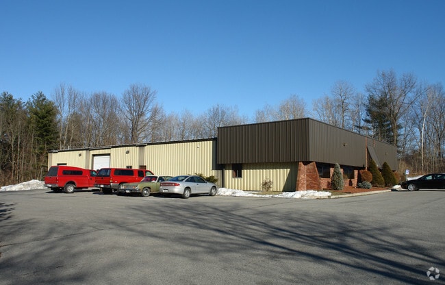
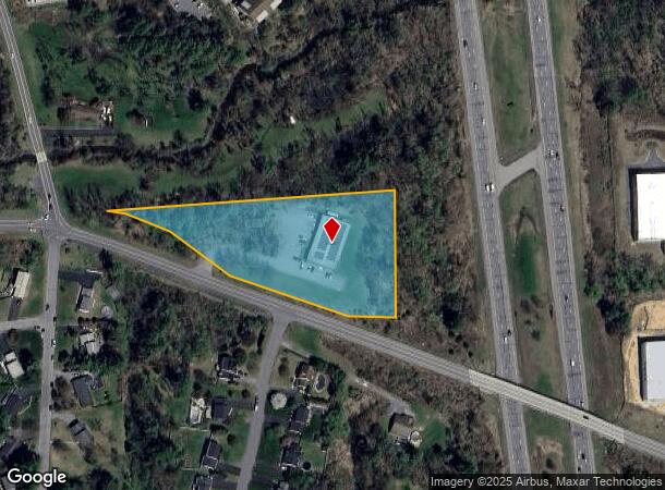
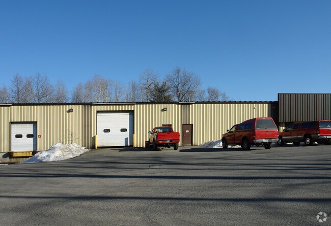
453 Kinns Rd
Albany-Schenectady-Troy, NY
Saratoga
412400-265-000-0001-024-002-0000
New York
Manufacturinglight
24.002
2025
3.30 AC
2024
Saratoga County
062508
Albany/Schenectady/Troy
10,000 SF
DEMOGRAPHICS near 453 Kinns Rd
1 Mile
3 Mile
5 Mile
2024 Total Population
2,679
27,592
63,586
2029 Population
2,726
28,241
65,093
Pop Growth 2024-2029
+ 1.75%
+ 2.35%
+ 2.37%
Average Age
43
42
43
2024 Total Households
1,042
11,106
26,323
HH Growth 2024-2029
+ 1.54%
+ 2.23%
+ 2.23%
Median Household Inc
$105,067
$106,573
$100,753
Avg Household Size
2.50
2.40
2.40
2024 Avg HH Vehicles
2.00
2.00
2.00
Median Home Value
$325,898
$337,660
$326,949
Median Year Built
1978
1984
1985
Nearby Places
- Restaurants
- Banks
- Shops
- Fitness
- Groceries
PUBLIC TRANSPORTATION
AIRPORT
Albany International
DRIVE
WALK
Distance
Albany International
19 min
13.6 mi
Freight Ports
Albany, NY Port
DRIVE
WALK
Distance
Albany, NY Port
34 min
24.0 mi
Nearby Properties
Address
Land Use
TOTAL SIZE
Lot Size
Zoning
Address
Land Use
TOTAL SIZE
Lot Size
Zoning
247,950 SF
236.68 AC
01 - NOT Z
Address
Land Use
TOTAL SIZE
Lot Size
Zoning
2,655 SF
47.22 AC
07 - MIXED
Address
Land Use
TOTAL SIZE
Lot Size
Zoning
5,091 SF
33.35 AC
02 - SINGL
Address
Land Use
TOTAL SIZE
Lot Size
Zoning
341,411 SF
62.74 AC
05 - COMME
Address
Land Use
TOTAL SIZE
Lot Size
Zoning
14,694 SF
20.87 AC
PDD
Address
Land Use
TOTAL SIZE
Lot Size
Zoning
14,694 SF
24.67 AC
PDD
Address
Land Use
TOTAL SIZE
Lot Size
Zoning
156,601 SF
13.69 AC
05 - COMME
Address
Land Use
TOTAL SIZE
Lot Size
Zoning
163,464 SF
7.06 AC
R67W
Address
Land Use
TOTAL SIZE
Lot Size
Zoning
109,323 SF
45.52 AC
05 - COMME
Address
Land Use
TOTAL SIZE
Lot Size
Zoning
14,694 SF
10.75 AC
PDD
Address
Land Use
TOTAL SIZE
Lot Size
Zoning
83,424 SF
25.63 AC
07 - MIXED
Address
Land Use
TOTAL SIZE
Lot Size
Zoning
183,632 SF
20.82 AC
05 - COMME
Address
Land Use
TOTAL SIZE
Lot Size
Zoning
125,739 SF
20.02 AC
05 - COMME
Address
Land Use
TOTAL SIZE
Lot Size
Zoning
147,200 SF
0.89 AC
05 - COMME
Address
Land Use
TOTAL SIZE
Lot Size
Zoning
52,117 SF
12.18 AC
08 - GOVER
Address
Land Use
TOTAL SIZE
Lot Size
Zoning
30,040 SF
8.04 AC
05 - COMME
Address
Land Use
TOTAL SIZE
Lot Size
Zoning
53,240 SF
9.80 AC
07 - MIXED
Address
Land Use
TOTAL SIZE
Lot Size
Zoning
134,095 SF
15.39 AC
05 - COMME
Address
Land Use
TOTAL SIZE
Lot Size
Zoning
38,110 SF
7.01 AC
05 - COMME
Address
Land Use
TOTAL SIZE
Lot Size
Zoning
58,966 SF
8.03 AC
07 - MIXED
Address
Land Use
TOTAL SIZE
Lot Size
Zoning
11,676 SF
15.36 AC
R67W
Address
Land Use
TOTAL SIZE
Lot Size
Zoning
88,110 SF
11.52 AC
05 - COMME
Address
Land Use
TOTAL SIZE
Lot Size
Zoning
81,168 SF
7.96 AC
07 - MIXED
Address
Land Use
TOTAL SIZE
Lot Size
Zoning
1,440 SF
0.34 AC
05 - COMME
Address
Land Use
TOTAL SIZE
Lot Size
Zoning
65,532 SF
25.25 AC
06 - INDUS
Address
Land Use
TOTAL SIZE
Lot Size
Zoning
140,200 SF
13.47 AC
06 - INDUS
Address
Land Use
TOTAL SIZE
Lot Size
Zoning
64,751 SF
48.27 AC
08 - GOVER
Address
Land Use
TOTAL SIZE
Lot Size
Zoning
116,325 SF
13.41 AC
07 - MIXED
Address
Land Use
TOTAL SIZE
Lot Size
Zoning
78,233 SF
3.71 AC
05 - COMME
Address
Land Use
TOTAL SIZE
Lot Size
Zoning
33,330 SF
31.64 AC
02 - SINGL
The World's #1 Commercial Real Estate Marketplace
Connect with us
© 2025 CoStar Group
The information above has been obtained from sources believed reliable. While we do not doubt its accuracy we have not verified it and make no guarantee, warranty or representation about it. It is your responsibility to independently confirm its accuracy and completeness. Any projections, opinions, assumptions, or estimates used are for example only and do not represent the current or future performance of the property. The value of this transaction to you depends on tax and other factors which should be evaluated by your tax, financial, and legal advisors. You and your advisors should conduct a careful, independent investigation of the property to determine to your satisfaction the suitability of the property for your needs.