Property Record
4530 Lower Beaver Rd, Des Moines, IA 50310
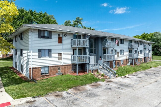

Property Detail
4530 Lower Beaver Rd
100-10007203001
LTS 3, 4 & 5 MONTEREY PARK PLAZA
Apartment
POLK
R-4
Iowa
B and X Area of moderate flood hazard, usually the area between the limits of the 100-year and 500-year floods.
3,4,5
2024
7.21 AC
2025
Lower Beaver
000704
Des Moines
139,947 SF
Des Moines-West Des Moines, IA
NEARBY LISTINGS FOR SALE OR LEASE
DEMOGRAPHICS near 4530 Lower Beaver Rd
1 mile
3 mile
5 mile
2025 Total Population
9,136
84,259
200,478
2030 Population
9,397
87,708
208,937
Pop Growth 2025-2030
+ 2.86%
+ 4.09%
+ 4.22%
Average Age
39
38
38
2025 Total Households
3,600
34,402
84,676
HH Growth 2025-2030
+ 3.06%
+ 4.28%
+ 4.54%
Median Household Inc
$73,451
$68,732
$70,001
Avg Household Size
2.50
2.30
2.20
2025 Avg HH Vehicles
2.00
2.00
2.00
Median Home Value
$241,968
$228,145
$251,550
Median Year Built
1961
1957
1969
Nearby Places
Map Layers
Map Styles
 Street
 Aerial
Transit
 Traffic
 Biking
Places
Listings with unknown addresses are not visible on the map
- Restaurants
- Banks
- Shops
- Fitness
- Groceries
PUBLIC TRANSPORTATION
AIRPORT
Des Moines International
Drive
Walk
Distance
Des Moines International
21 min
9.0 mi
Freight Ports
Port Milwaukee
Drive
Walk
Distance
Port Milwaukee
420 min
374.5 mi
SALE & LEASE HISTORY
LISTING DATE
SALE/LEASE

May 01, 2024
For Sale
Nearby Properties
Address
Land Use
TOTAL SIZE
Lot Size
Zoning
Address
Land Use
TOTAL SIZE
Lot Size
Zoning
339,258 SF
9.50 AC
R3
Address
Land Use
TOTAL SIZE
Lot Size
Zoning
274,736 SF
10.27 AC
R-3
Address
Land Use
TOTAL SIZE
Lot Size
Zoning
162,578 SF
6.37 AC
Address
Land Use
TOTAL SIZE
Lot Size
Zoning
254,071 SF
9.17 AC
R3
Address
Land Use
TOTAL SIZE
Lot Size
Zoning
179,663 SF
2.27 AC
PUD
Address
Land Use
TOTAL SIZE
Lot Size
Zoning
82,525 SF
0.97 AC
Address
Land Use
TOTAL SIZE
Lot Size
Zoning
96,450 SF
9.90 AC
R3
Address
Land Use
TOTAL SIZE
Lot Size
Zoning
307,734 SF
23.59 AC
R-3
Address
Land Use
TOTAL SIZE
Lot Size
Zoning
71,938 SF
8.23 AC
C-O
Address
Land Use
TOTAL SIZE
Lot Size
Zoning
1,838,971 SF
76.24 AC
HI
Address
Land Use
TOTAL SIZE
Lot Size
Zoning
101,592 SF
7.79 AC
PUD
Address
Land Use
TOTAL SIZE
Lot Size
Zoning
386,236 SF
9.62 AC
C-4
Address
Land Use
TOTAL SIZE
Lot Size
Zoning
117,272 SF
3.46 AC
R1-60
Address
Land Use
TOTAL SIZE
Lot Size
Zoning
141,377 SF
3.16 AC
Address
Land Use
TOTAL SIZE
Lot Size
Zoning
374,551 SF
9.37 AC
R-3
Address
Land Use
TOTAL SIZE
Lot Size
Zoning
188,453 SF
14.20 AC
R-3
Address
Land Use
TOTAL SIZE
Lot Size
Zoning
110,637 SF
11.05 AC
R-3
Address
Land Use
TOTAL SIZE
Lot Size
Zoning
223,876 SF
15.01 AC
Address
Land Use
TOTAL SIZE
Lot Size
Zoning
107,395 SF
6.78 AC
R-3
Address
Land Use
TOTAL SIZE
Lot Size
Zoning
143,831 SF
16.12 AC
PUD
Address
Land Use
TOTAL SIZE
Lot Size
Zoning
120,808 SF
4.41 AC
PUD
Address
Land Use
TOTAL SIZE
Lot Size
Zoning
56,478 SF
5.86 AC
Address
Land Use
TOTAL SIZE
Lot Size
Zoning
158,256 SF
8.87 AC
R-3
Address
Land Use
TOTAL SIZE
Lot Size
Zoning
203,062 SF
17.82 AC
C-2
Address
Land Use
TOTAL SIZE
Lot Size
Zoning
92,392 SF
12.40 AC
C-2
Address
Land Use
TOTAL SIZE
Lot Size
Zoning
78,354 SF
6.16 AC
R1-60
Address
Land Use
TOTAL SIZE
Lot Size
Zoning
63,201 SF
3.67 AC
Address
Land Use
TOTAL SIZE
Lot Size
Zoning
548,576 SF
19.48 AC
LI
Address
Land Use
TOTAL SIZE
Lot Size
Zoning
47,687 SF
13.61 AC
PUD
Address
Land Use
TOTAL SIZE
Lot Size
Zoning
95,400 SF
4.40 AC
PUD
The World's #1 Commercial Real Estate Marketplace
Connect with us
© 2026 CoStar Group
The information above has been obtained from sources believed reliable. While we do not doubt its accuracy we have not verified it and make no guarantee, warranty or representation about it. It is your responsibility to independently confirm its accuracy and completeness. Any projections, opinions, assumptions, or estimates used are for example only and do not represent the current or future performance of the property. The value of this transaction to you depends on tax and other factors which should be evaluated by your tax, financial, and legal advisors. You and your advisors should conduct a careful, independent investigation of the property to determine to your satisfaction the suitability of the property for your needs.