Property Record
4530 S Leeward Ridge Dr, Riverview, FL 33578
Save to a Folder
{{folder.Name}}
{{folder.ListingIds.length}} Properties
{{folder.ListingIds.length}} Property
Create a New Folder
Property Detail
4530 S Leeward Ridge Dr
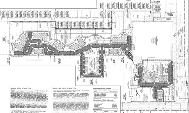
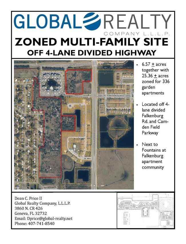
U-01-30-19-663-000001-66080.3
HARVEST CREEK VILLAGE LOT 5 BLOCK 16
Multifamilydwelling
HILLSBOROUGH
PD
Florida
B and X Area of moderate flood hazard, usually the area between the limits of the 100-year and 500-year floods.
5
2024
33.26 AC
2025
East Tampa
013703
Tampa/St Petersburg
366,971 SF
Tampa-St. Petersburg-Clearwater, FL
NEARBY LISTINGS FOR SALE OR LEASE
DEMOGRAPHICS near 4530 S Leeward Ridge Dr
1 mile
3 mile
5 mile
2025 Total Population
14,734
86,935
176,569
2030 Population
16,117
93,987
190,706
Pop Growth 2025-2030
+ 9.39%
+ 8.11%
+ 8.01%
Average Age
36
37
38
2025 Total Households
5,867
35,233
67,865
HH Growth 2025-2030
+ 9.58%
+ 8.32%
+ 8.26%
Median Household Inc
$79,128
$75,573
$74,464
Avg Household Size
2.50
2.40
2.50
2025 Avg HH Vehicles
2.00
2.00
2.00
Median Home Value
$329,867
$327,751
$345,826
Median Year Built
2010
2003
1999
Nearby Places
Map Layers
Map Styles
 Street
 Aerial
Layers
 Traffic
 Biking
Places
Listings with unknown addresses are not visible on the map
- Restaurants
- Banks
- Shops
- Fitness
- Groceries
PUBLIC TRANSPORTATION
AIRPORT
Tampa International
Drive
Walk
Distance
Tampa International
32 min
18.8 mi
St Pete-Clearwater International
Drive
Walk
Distance
St Pete-Clearwater International
49 min
28.0 mi
Freight Ports
Port of Tampa Bay
Drive
Walk
Distance
Port of Tampa Bay
16 min
8.1 mi
SALE & LEASE HISTORY
LISTING DATE
SALE/LEASE

Sep 24, 2016
For Sale
Nearby Properties
Address
Land Use
TOTAL SIZE
Lot Size
Zoning
Address
Land Use
TOTAL SIZE
Lot Size
Zoning
733,263 SF
72.88 AC
PD
Address
Land Use
TOTAL SIZE
Lot Size
Zoning
589,526 SF
18.06 AC
PD
Address
Land Use
TOTAL SIZE
Lot Size
Zoning
574,867 SF
31.07 AC
PD
Address
Land Use
TOTAL SIZE
Lot Size
Zoning
991,388 SF
99.01 AC
M
Address
Land Use
TOTAL SIZE
Lot Size
Zoning
325,857 SF
16.32 AC
PD
Address
Land Use
TOTAL SIZE
Lot Size
Zoning
406,097 SF
25.82 AC
PD
Address
Land Use
TOTAL SIZE
Lot Size
Zoning
349,931 SF
19.43 AC
PD
Address
Land Use
TOTAL SIZE
Lot Size
Zoning
363,226 SF
27.91 AC
PD
Address
Land Use
TOTAL SIZE
Lot Size
Zoning
399,989 SF
25.63 AC
PD
Address
Land Use
TOTAL SIZE
Lot Size
Zoning
378,206 SF
20.48 AC
PD
Address
Land Use
TOTAL SIZE
Lot Size
Zoning
378,775 SF
16 AC
PD
Address
Land Use
TOTAL SIZE
Lot Size
Zoning
427,830 SF
23.95 AC
PD
Address
Land Use
TOTAL SIZE
Lot Size
Zoning
317,413 SF
14.60 AC
PD
Address
Land Use
TOTAL SIZE
Lot Size
Zoning
349,531 SF
17.15 AC
PD
Address
Land Use
TOTAL SIZE
Lot Size
Zoning
423,284 SF
20.91 AC
PD
Address
Land Use
TOTAL SIZE
Lot Size
Zoning
343,903 SF
16.71 AC
PD
Address
Land Use
TOTAL SIZE
Lot Size
Zoning
338,628 SF
14.60 AC
PD
Address
Land Use
TOTAL SIZE
Lot Size
Zoning
339,482 SF
19.15 AC
PD
Address
Land Use
TOTAL SIZE
Lot Size
Zoning
284,156 SF
19.32 AC
PD
Address
Land Use
TOTAL SIZE
Lot Size
Zoning
426,236 SF
21.09 AC
PD
Address
Land Use
TOTAL SIZE
Lot Size
Zoning
259,451 SF
13.73 AC
PD
Address
Land Use
TOTAL SIZE
Lot Size
Zoning
378,173 SF
20.06 AC
PD
Address
Land Use
TOTAL SIZE
Lot Size
Zoning
337,223 SF
35.27 AC
PD
Address
Land Use
TOTAL SIZE
Lot Size
Zoning
328,279 SF
15.31 AC
PD
Address
Land Use
TOTAL SIZE
Lot Size
Zoning
301,133 SF
11.56 AC
PD
Address
Land Use
TOTAL SIZE
Lot Size
Zoning
301,955 SF
11.92 AC
PD
Address
Land Use
TOTAL SIZE
Lot Size
Zoning
391,668 SF
27.43 AC
PD
Address
Land Use
TOTAL SIZE
Lot Size
Zoning
273,935 SF
15.42 AC
PD
Address
Land Use
TOTAL SIZE
Lot Size
Zoning
297,529 SF
13.38 AC
PD
The World's #1 Commercial Real Estate Marketplace
Connect with us
© 2026 CoStar Group
The information above has been obtained from sources believed reliable. While we do not doubt its accuracy we have not verified it and make no guarantee, warranty or representation about it. It is your responsibility to independently confirm its accuracy and completeness. Any projections, opinions, assumptions, or estimates used are for example only and do not represent the current or future performance of the property. The value of this transaction to you depends on tax and other factors which should be evaluated by your tax, financial, and legal advisors. You and your advisors should conduct a careful, independent investigation of the property to determine to your satisfaction the suitability of the property for your needs.