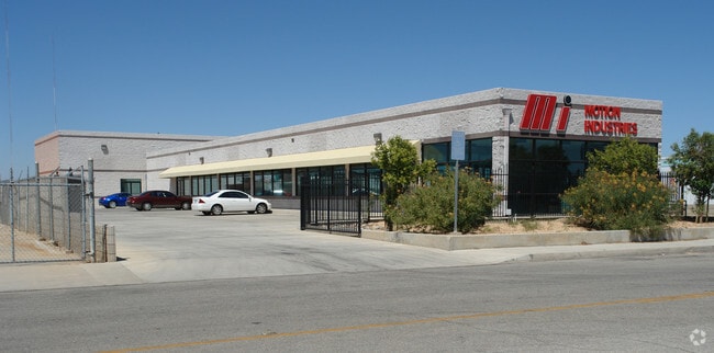
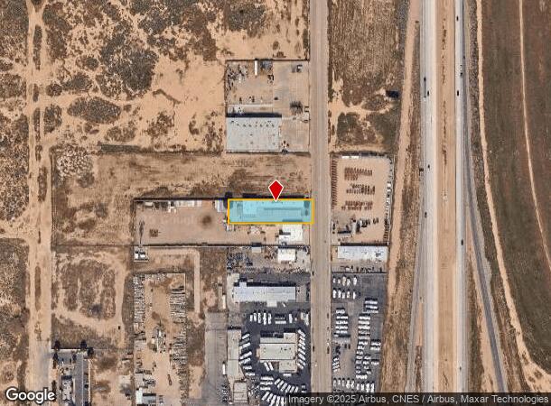
Property Record
45313 23Rd St W, Lancaster, CA 93536


NEARBY LISTINGS FOR SALE OR LEASE
Property Detail
45313 23Rd St W
3114-014-012
*TR=PARCEL MAP AS PER BK 145 P 5-6 OF PM LOT 3
Storebuilding
Los Angeles
X
California
06037C0410F
3
2024
0.57 AC
2025
Antelope Valley
900901
Los Angeles
7,250 SF
Los Angeles-Long Beach-Glendale, CA
DEMOGRAPHICS near 45313 23Rd St W
1 Mile
3 Mile
5 Mile
2024 Total Population
10,141
73,962
150,651
2029 Population
9,765
71,830
146,299
Pop Growth 2024-2029
(3.71%)
(2.88%)
(2.89%)
Average Age
37
37
37
2024 Total Households
3,139
24,673
48,064
HH Growth 2024-2029
(4.01%)
(3.07%)
(3.10%)
Median Household Inc
$67,697
$60,189
$62,303
Avg Household Size
3.10
2.90
3.00
2024 Avg HH Vehicles
2.00
2.00
2.00
Median Home Value
$320,149
$332,882
$320,936
Median Year Built
1989
1983
1984
Nearby Places
Map Layers
Map Styles
 Street
 Aerial
- Restaurants
- Banks
- Shops
- Fitness
- Groceries
PUBLIC TRANSPORTATION
COMMUTER RAIL
Lancaster (Antelope Valley Line - Southern California Regional Rail Authority (Metrolink))
DRIVE
WALK
Distance
Lancaster (Antelope Valley Line - Southern California Regional Rail Authority (Metrolink))
5 min
2.6 mi
Nearby Properties
Address
Land Use
TOTAL SIZE
Lot Size
Zoning
Address
Land Use
TOTAL SIZE
Lot Size
Zoning
2,922,905 SF
85.01 AC
LRLI
Address
Land Use
TOTAL SIZE
Lot Size
Zoning
234,378 SF
15.25 AC
Address
Land Use
TOTAL SIZE
Lot Size
Zoning
153,117 SF
14.12 AC
LRSP80-01*
Address
Land Use
TOTAL SIZE
Lot Size
Zoning
160,028 SF
10.81 AC
LRMDR*
Address
Land Use
TOTAL SIZE
Lot Size
Zoning
179,304 SF
12.43 AC
LRMDR*
Address
Land Use
TOTAL SIZE
Lot Size
Zoning
552,178 SF
17.77 AC
LRHI*
Address
Land Use
TOTAL SIZE
Lot Size
Zoning
212,198 SF
18.27 AC
LRSP80-01*
Address
Land Use
TOTAL SIZE
Lot Size
Zoning
129,896 SF
9.10 AC
LRRPD70001
Address
Land Use
TOTAL SIZE
Lot Size
Zoning
465,697 SF
27.82 AC
LRSP*
Address
Land Use
TOTAL SIZE
Lot Size
Zoning
74,213 SF
4.46 AC
LRA17000*
Address
Land Use
TOTAL SIZE
Lot Size
Zoning
185,527 SF
9.65 AC
LRR325U*
Address
Land Use
TOTAL SIZE
Lot Size
Zoning
60,113 SF
2.03 AC
LRCPD
Address
Land Use
TOTAL SIZE
Lot Size
Zoning
89,351 SF
17.97 AC
LRMDR
Address
Land Use
TOTAL SIZE
Lot Size
Zoning
132,584 SF
8.66 AC
LRMDR*
Address
Land Use
TOTAL SIZE
Lot Size
Zoning
170,697 SF
9.29 AC
LRRPD12U*
Address
Land Use
TOTAL SIZE
Lot Size
Zoning
90,429 SF
4.59 AC
LRHDR*
Address
Land Use
TOTAL SIZE
Lot Size
Zoning
90,429 SF
4.38 AC
LRHDR*
Address
Land Use
TOTAL SIZE
Lot Size
Zoning
214,178 SF
13.95 AC
LRRA7000*
Address
Land Use
TOTAL SIZE
Lot Size
Zoning
145,593 SF
5.18 AC
LRC3*
Address
Land Use
TOTAL SIZE
Lot Size
Zoning
76,093 SF
1.37 AC
LRC3*
Address
Land Use
TOTAL SIZE
Lot Size
Zoning
97,566 SF
8.81 AC
LRC3*
Address
Land Use
TOTAL SIZE
Lot Size
Zoning
73,248 SF
3.56 AC
LRR325UDP*
Address
Land Use
TOTAL SIZE
Lot Size
Zoning
107,924 SF
8.95 AC
LRRPD10000
Address
Land Use
TOTAL SIZE
Lot Size
Zoning
127,975 SF
4.77 AC
LRC3DP*
Address
Land Use
TOTAL SIZE
Lot Size
Zoning
70,456 SF
3.05 AC
LRRC
Address
Land Use
TOTAL SIZE
Lot Size
Zoning
183,296 SF
11.75 AC
LRRPD25U*
Address
Land Use
TOTAL SIZE
Lot Size
Zoning
135,028 SF
12.10 AC
LRC3*
Address
Land Use
TOTAL SIZE
Lot Size
Zoning
81,668 SF
5.47 AC
LRSP80-01*
Address
Land Use
TOTAL SIZE
Lot Size
Zoning
137,190 SF
11.24 AC
LRSP80-01*
The World's #1 Commercial Real Estate Marketplace
Connect with us
© 2026 CoStar Group
The information above has been obtained from sources believed reliable. While we do not doubt its accuracy we have not verified it and make no guarantee, warranty or representation about it. It is your responsibility to independently confirm its accuracy and completeness. Any projections, opinions, assumptions, or estimates used are for example only and do not represent the current or future performance of the property. The value of this transaction to you depends on tax and other factors which should be evaluated by your tax, financial, and legal advisors. You and your advisors should conduct a careful, independent investigation of the property to determine to your satisfaction the suitability of the property for your needs.