Property Record
4536 N Laporte Ave, Chicago, IL 60630


NEARBY LISTINGS FOR SALE OR LEASE
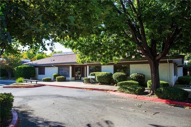
Property Detail
4536 N Laporte Ave
Chico, CA
Linford Ward Sub
006-260-041-000
PTN LT 5 & PTN LT 4 LINFORD WARD SUB
Financialbuilding
Butte
X
California
06007C0340E
5,4
2024
0.70 AC
2025
Redding/Chico
000700
Other Market Areas
4,801 SF
DEMOGRAPHICS near 4536 N Laporte Ave
1 Mile
3 Mile
5 Mile
2024 Total Population
14,108
91,407
106,129
2029 Population
13,161
87,048
101,165
Pop Growth 2024-2029
(6.71%)
(4.77%)
(4.68%)
Average Age
41
37
37
2024 Total Households
6,461
37,230
43,307
HH Growth 2024-2029
(6.98%)
(5.03%)
(4.93%)
Median Household Inc
$64,786
$66,822
$69,251
Avg Household Size
2.10
2.30
2.30
2024 Avg HH Vehicles
2.00
2.00
2.00
Median Home Value
$353,302
$413,149
$431,128
Median Year Built
1973
1980
1982
Nearby Places
Map Layers
Map Styles
 Street
 Aerial
- Restaurants
- Banks
- Shops
- Fitness
- Groceries
PUBLIC TRANSPORTATION
COMMUTER RAIL
Chico Amtrak (Coast Starlight - Amtrak)
DRIVE
WALK
Distance
Chico Amtrak (Coast Starlight - Amtrak)
7 min
2.9 mi
Freight Ports
Port of Stockton
DRIVE
WALK
Distance
Port of Stockton
161 min
133.2 mi
SALE & LEASE HISTORY
LISTING DATE
SALE/LEASE

Oct 08, 2024
For Lease
Nearby Properties
Address
Land Use
TOTAL SIZE
Lot Size
Zoning
Address
Land Use
TOTAL SIZE
Lot Size
Zoning
150,000 SF
2.31 AC
Address
Land Use
TOTAL SIZE
Lot Size
Zoning
135,668 SF
3.43 AC
PQ
Address
Land Use
TOTAL SIZE
Lot Size
Zoning
194,612 SF
4.72 AC
R3
Address
Land Use
TOTAL SIZE
Lot Size
Zoning
12.63 AC
R1
Address
Land Use
TOTAL SIZE
Lot Size
Zoning
8.55 AC
R3
Address
Land Use
TOTAL SIZE
Lot Size
Zoning
90,859 SF
5.60 AC
PQ
Address
Land Use
TOTAL SIZE
Lot Size
Zoning
185,744 SF
10.15 AC
Address
Land Use
TOTAL SIZE
Lot Size
Zoning
84,280 SF
1.60 AC
R4
Address
Land Use
TOTAL SIZE
Lot Size
Zoning
190,996 SF
7.94 AC
R3
Address
Land Use
TOTAL SIZE
Lot Size
Zoning
8,008 SF
8.79 AC
Address
Land Use
TOTAL SIZE
Lot Size
Zoning
9,784 SF
3.97 AC
R1
Address
Land Use
TOTAL SIZE
Lot Size
Zoning
126,476 SF
6.75 AC
R3
Address
Land Use
TOTAL SIZE
Lot Size
Zoning
104,992 SF
5.64 AC
CN
Address
Land Use
TOTAL SIZE
Lot Size
Zoning
133,120 SF
5.37 AC
R3
Address
Land Use
TOTAL SIZE
Lot Size
Zoning
61,571 SF
6.47 AC
Address
Land Use
TOTAL SIZE
Lot Size
Zoning
158,426 SF
16.19 AC
M1
Address
Land Use
TOTAL SIZE
Lot Size
Zoning
13,459 SF
3.61 AC
Address
Land Use
TOTAL SIZE
Lot Size
Zoning
1.58 AC
Address
Land Use
TOTAL SIZE
Lot Size
Zoning
247,613 SF
10.77 AC
CR
Address
Land Use
TOTAL SIZE
Lot Size
Zoning
160,354 SF
11.39 AC
00
Address
Land Use
TOTAL SIZE
Lot Size
Zoning
175,392 SF
14.83 AC
Address
Land Use
TOTAL SIZE
Lot Size
Zoning
16,020 SF
12.01 AC
Address
Land Use
TOTAL SIZE
Lot Size
Zoning
83,886 SF
4.55 AC
Address
Land Use
TOTAL SIZE
Lot Size
Zoning
142,712 SF
7.24 AC
Address
Land Use
TOTAL SIZE
Lot Size
Zoning
132,768 SF
9.65 AC
R3
Address
Land Use
TOTAL SIZE
Lot Size
Zoning
44,492 SF
2.05 AC
R3
Address
Land Use
TOTAL SIZE
Lot Size
Zoning
92,292 SF
5.14 AC
Address
Land Use
TOTAL SIZE
Lot Size
Zoning
3.30 AC
CR
Address
Land Use
TOTAL SIZE
Lot Size
Zoning
123,494 SF
6.84 AC
R3
Address
Land Use
TOTAL SIZE
Lot Size
Zoning
24.26 AC
The World's #1 Commercial Real Estate Marketplace
Connect with us
© 2026 CoStar Group
The information above has been obtained from sources believed reliable. While we do not doubt its accuracy we have not verified it and make no guarantee, warranty or representation about it. It is your responsibility to independently confirm its accuracy and completeness. Any projections, opinions, assumptions, or estimates used are for example only and do not represent the current or future performance of the property. The value of this transaction to you depends on tax and other factors which should be evaluated by your tax, financial, and legal advisors. You and your advisors should conduct a careful, independent investigation of the property to determine to your satisfaction the suitability of the property for your needs.