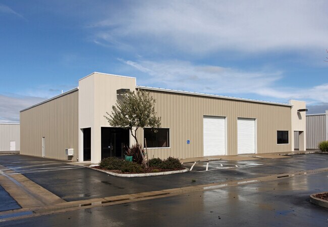
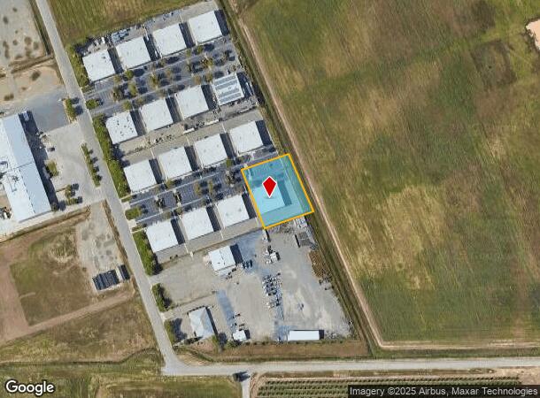
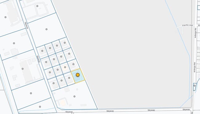
Property Record
4537 Skyway Dr, Olivehurst, CA 95961
NEARBY LISTINGS FOR SALE OR LEASE
Property Detail
4537 Skyway Dr
Yuba City, CA
2004-14
013-560-069-000
P-8 PM 04-14 82/21-22
Warehouse
Yuba
A
California
06115C0405D
2-8
2024
0.85 AC
2025
Marysville/Yuba City
040400
Sacramento
7,920 SF
DEMOGRAPHICS near 4537 Skyway Dr
1 Mile
3 Mile
5 Mile
2024 Total Population
3,981
41,551
96,647
2029 Population
4,458
45,322
101,949
Pop Growth 2024-2029
+ 11.98%
+ 9.08%
+ 5.49%
Average Age
35
35
36
2024 Total Households
1,148
12,399
30,993
HH Growth 2024-2029
+ 12.37%
+ 9.57%
+ 5.72%
Median Household Inc
$55,368
$68,055
$62,894
Avg Household Size
3.40
3.20
3.00
2024 Avg HH Vehicles
2.00
2.00
2.00
Median Home Value
$267,629
$312,500
$317,527
Median Year Built
1991
1995
1982
Nearby Places
Map Layers
Map Styles
 Street
 Aerial
- Restaurants
- Banks
- Shops
- Fitness
- Groceries
PUBLIC TRANSPORTATION
AIRPORT
Sacramento International
DRIVE
WALK
Distance
Sacramento International
47 min
34.8 mi
SALE & LEASE HISTORY
LISTING DATE
SALE/LEASE

Sep 25, 2016
For Lease
Sep 24, 2016
For Sale
Sep 09, 2021
For Sale
Apr 16, 2025
For Lease
Nearby Properties
Address
Land Use
TOTAL SIZE
Lot Size
Zoning
Address
Land Use
TOTAL SIZE
Lot Size
Zoning
154,480 SF
13.44 AC
C
Address
Land Use
TOTAL SIZE
Lot Size
Zoning
51,371 SF
10.13 AC
Address
Land Use
TOTAL SIZE
Lot Size
Zoning
150,742 SF
7.91 AC
R3
Address
Land Use
TOTAL SIZE
Lot Size
Zoning
107,749 SF
9.33 AC
C
Address
Land Use
TOTAL SIZE
Lot Size
Zoning
203,353 SF
11.49 AC
C
Address
Land Use
TOTAL SIZE
Lot Size
Zoning
Address
Land Use
TOTAL SIZE
Lot Size
Zoning
1,800 SF
6 AC
M-1
Address
Land Use
TOTAL SIZE
Lot Size
Zoning
30.13 AC
AI
Address
Land Use
TOTAL SIZE
Lot Size
Zoning
63,320 SF
3.88 AC
R-03
Address
Land Use
TOTAL SIZE
Lot Size
Zoning
19,950 SF
7.66 AC
M-1
Address
Land Use
TOTAL SIZE
Lot Size
Zoning
40,045 SF
1.38 AC
C
Address
Land Use
TOTAL SIZE
Lot Size
Zoning
4.79 AC
R-2
Address
Land Use
TOTAL SIZE
Lot Size
Zoning
21,746 SF
2.18 AC
Address
Land Use
TOTAL SIZE
Lot Size
Zoning
53,952 SF
4.14 AC
R-02
Address
Land Use
TOTAL SIZE
Lot Size
Zoning
417,732 SF
5.45 AC
Address
Land Use
TOTAL SIZE
Lot Size
Zoning
124,835 SF
6.72 AC
C
Address
Land Use
TOTAL SIZE
Lot Size
Zoning
26,986 SF
1.67 AC
C
Address
Land Use
TOTAL SIZE
Lot Size
Zoning
100,000 SF
11.78 AC
M-1
Address
Land Use
TOTAL SIZE
Lot Size
Zoning
41,003 SF
2.98 AC
R-02
Address
Land Use
TOTAL SIZE
Lot Size
Zoning
4,152 SF
1.22 AC
CMX
Address
Land Use
TOTAL SIZE
Lot Size
Zoning
3,924 SF
1.03 AC
C
Address
Land Use
TOTAL SIZE
Lot Size
Zoning
12,663 SF
1.24 AC
Address
Land Use
TOTAL SIZE
Lot Size
Zoning
Address
Land Use
TOTAL SIZE
Lot Size
Zoning
417,732 SF
5.45 AC
C
Address
Land Use
TOTAL SIZE
Lot Size
Zoning
33,002 SF
1 AC
C1
Address
Land Use
TOTAL SIZE
Lot Size
Zoning
7,500 SF
6.24 AC
M-1
Address
Land Use
TOTAL SIZE
Lot Size
Zoning
30,056 SF
1.36 AC
C
Address
Land Use
TOTAL SIZE
Lot Size
Zoning
9,152 SF
1.40 AC
RRE
Address
Land Use
TOTAL SIZE
Lot Size
Zoning
77,696 SF
4 AC
R-02
Address
Land Use
TOTAL SIZE
Lot Size
Zoning
1,258 SF
563.64 AC
AE-40
The World's #1 Commercial Real Estate Marketplace
Connect with us
© 2026 CoStar Group
The information above has been obtained from sources believed reliable. While we do not doubt its accuracy we have not verified it and make no guarantee, warranty or representation about it. It is your responsibility to independently confirm its accuracy and completeness. Any projections, opinions, assumptions, or estimates used are for example only and do not represent the current or future performance of the property. The value of this transaction to you depends on tax and other factors which should be evaluated by your tax, financial, and legal advisors. You and your advisors should conduct a careful, independent investigation of the property to determine to your satisfaction the suitability of the property for your needs.