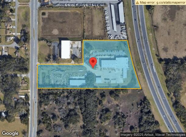
Property Record
4539 Nw 44Th Ave, Ocala, FL 34482

NEARBY LISTINGS FOR SALE OR LEASE
Property Detail
4539 Nw 44Th Ave
13689-004-00
SEC 34 TWP 14 RGE 21 COM AT THE NW COR OF NE 1/4 OF SEC 34 TH S 00-34-26 W 1080.17 FT TH S 89-45-51 E 66.75 FT TH S 00-33-36 W 269.93 FT TO THE POB TH S 89-44-39 E 507.01 FT TH N 00-15-13 E 270.10 FT TH S 89-45-51 E 509.18 FT TO A PT BEING ON A CURVE
Storebuilding
Marion
X
Florida
12083C0502E
10.29 AC
2024
Outlying Marion County
2024
Ocala
002503
Ocala, FL
49,305 SF
DEMOGRAPHICS near 4539 Nw 44Th Ave
1 Mile
3 Mile
5 Mile
2024 Total Population
846
15,073
50,106
2029 Population
966
17,125
56,628
Pop Growth 2024-2029
+ 14.18%
+ 13.61%
+ 13.02%
Average Age
57
47
41
2024 Total Households
451
6,675
19,569
HH Growth 2024-2029
+ 13.97%
+ 13.45%
+ 13.25%
Median Household Inc
$80,909
$54,093
$43,901
Avg Household Size
1.90
2.20
2.30
2024 Avg HH Vehicles
2.00
2.00
2.00
Median Home Value
$251,420
$192,325
$184,238
Median Year Built
2005
1996
1988
Nearby Places
Map Layers
Map Styles
 Street
 Aerial
- Restaurants
- Banks
- Shops
- Fitness
- Groceries
SALE & LEASE HISTORY
LISTING DATE
SALE/LEASE

Sep 24, 2016
For Sale
Sep 13, 2017
For Sale
Nearby Properties
Address
Land Use
TOTAL SIZE
Lot Size
Zoning
Address
Land Use
TOTAL SIZE
Lot Size
Zoning
704,765 SF
71.04 AC
GU
Address
Land Use
TOTAL SIZE
Lot Size
Zoning
1,085,670 SF
89.70 AC
M1
Address
Land Use
TOTAL SIZE
Lot Size
Zoning
612,196 SF
50.06 AC
M1
Address
Land Use
TOTAL SIZE
Lot Size
Zoning
617,520 SF
46.08 AC
M2
Address
Land Use
TOTAL SIZE
Lot Size
Zoning
441,040 SF
150.01 AC
M1
Address
Land Use
TOTAL SIZE
Lot Size
Zoning
458,983 SF
35.14 AC
M1
Address
Land Use
TOTAL SIZE
Lot Size
Zoning
444,381 SF
60 AC
M1
Address
Land Use
TOTAL SIZE
Lot Size
Zoning
403,023 SF
47.47 AC
M1
Address
Land Use
TOTAL SIZE
Lot Size
Zoning
350,895 SF
27.85 AC
M1
Address
Land Use
TOTAL SIZE
Lot Size
Zoning
140,920 SF
28.09 AC
M2
Address
Land Use
TOTAL SIZE
Lot Size
Zoning
146,091 SF
43.91 AC
M1
Address
Land Use
TOTAL SIZE
Lot Size
Zoning
9,854 SF
55.14 AC
B2
Address
Land Use
TOTAL SIZE
Lot Size
Zoning
29,068 SF
22.30 AC
PD
Address
Land Use
TOTAL SIZE
Lot Size
Zoning
79,199 SF
13.54 AC
B2
Address
Land Use
TOTAL SIZE
Lot Size
Zoning
160,796 SF
25.59 AC
M2
Address
Land Use
TOTAL SIZE
Lot Size
Zoning
384,930 SF
17.76 AC
M1
Address
Land Use
TOTAL SIZE
Lot Size
Zoning
94,360 SF
17.51 AC
B5
Address
Land Use
TOTAL SIZE
Lot Size
Zoning
11,351 SF
3.51 AC
B2
Address
Land Use
TOTAL SIZE
Lot Size
Zoning
116,876 SF
23.78 AC
M2
Address
Land Use
TOTAL SIZE
Lot Size
Zoning
73,361 SF
23.20 AC
GU
Address
Land Use
TOTAL SIZE
Lot Size
Zoning
66,531 SF
26.96 AC
B2
Address
Land Use
TOTAL SIZE
Lot Size
Zoning
35,518 SF
9.98 AC
B2
Address
Land Use
TOTAL SIZE
Lot Size
Zoning
176,710 SF
11.88 AC
M1
Address
Land Use
TOTAL SIZE
Lot Size
Zoning
44,100 SF
9.60 AC
R3
Address
Land Use
TOTAL SIZE
Lot Size
Zoning
Address
Land Use
TOTAL SIZE
Lot Size
Zoning
63,200 SF
6.30 AC
B4
Address
Land Use
TOTAL SIZE
Lot Size
Zoning
89,640 SF
33.21 AC
B5
Address
Land Use
TOTAL SIZE
Lot Size
Zoning
72,855 SF
47.31 AC
B2
Address
Land Use
TOTAL SIZE
Lot Size
Zoning
39,979 SF
24.28 AC
GU
Address
Land Use
TOTAL SIZE
Lot Size
Zoning
35,158 SF
12 AC
GU
The World's #1 Commercial Real Estate Marketplace
Connect with us
© 2025 CoStar Group
The information above has been obtained from sources believed reliable. While we do not doubt its accuracy we have not verified it and make no guarantee, warranty or representation about it. It is your responsibility to independently confirm its accuracy and completeness. Any projections, opinions, assumptions, or estimates used are for example only and do not represent the current or future performance of the property. The value of this transaction to you depends on tax and other factors which should be evaluated by your tax, financial, and legal advisors. You and your advisors should conduct a careful, independent investigation of the property to determine to your satisfaction the suitability of the property for your needs.