Property Record
454 Arapahoe Ave, Boulder, CO 80302
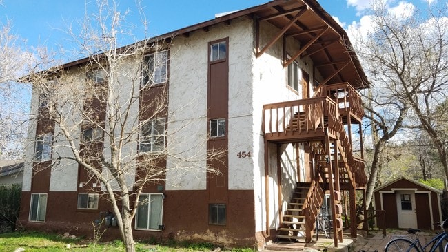


Property Detail
454 Arapahoe Ave
1461361-47-001
UNITS 1-3 MOUNTAIN VIEW HOMES
Multifamilydwelling
Boulder
B and X Area of moderate flood hazard, usually the area between the limits of the 100-year and 500-year floods.
Colorado
2025
0.28 AC
2025
Lower Arapahoe
012201
Denver
3,192 SF
Boulder, CO
NEARBY LISTINGS FOR SALE OR LEASE
DEMOGRAPHICS near 454 Arapahoe Ave
1 mile
3 mile
5 mile
2025 Total Population
13,354
81,611
113,878
2030 Population
13,423
81,718
113,787
Pop Growth 2025-2030
+ 0.52%
+ 0.13%
(0.08%)
Average Age
35
36
38
2025 Total Households
5,605
32,238
45,750
HH Growth 2025-2030
+ 0.46%
+ 0.24%
(0.04%)
Median Household Inc
$59,700
$68,213
$79,625
Avg Household Size
2.10
2.10
2.10
2025 Avg HH Vehicles
2.00
2.00
2.00
Median Home Value
$1,126,230
$1,041,250
$1,015,737
Median Year Built
1967
1976
1977
Nearby Places
Map Layers
Map Styles
 Street
 Aerial
Layers
 Traffic
 Biking
Places
Listings with unknown addresses are not visible on the map
- Restaurants
- Banks
- Shops
- Fitness
- Groceries
PUBLIC TRANSPORTATION
AIRPORT
Denver International
Drive
Walk
Distance
Denver International
54 min
44.0 mi
SALE & LEASE HISTORY
LISTING DATE
SALE/LEASE

May 29, 2019
For Sale
Nearby Properties
Address
Land Use
TOTAL SIZE
Lot Size
Zoning
Address
Land Use
TOTAL SIZE
Lot Size
Zoning
1,285,025 SF
17.46 AC
Address
Land Use
TOTAL SIZE
Lot Size
Zoning
30.08 AC
Address
Land Use
TOTAL SIZE
Lot Size
Zoning
14.66 AC
Address
Land Use
TOTAL SIZE
Lot Size
Zoning
941,000 SF
44 SF
Address
Land Use
TOTAL SIZE
Lot Size
Zoning
171.91 AC
Address
Land Use
TOTAL SIZE
Lot Size
Zoning
1,892,750 SF
200 AC
Address
Land Use
TOTAL SIZE
Lot Size
Zoning
155,000 SF
205.33 AC
Address
Land Use
TOTAL SIZE
Lot Size
Zoning
599,605 SF
4.46 AC
Address
Land Use
TOTAL SIZE
Lot Size
Zoning
842,665 SF
59.42 AC
Address
Land Use
TOTAL SIZE
Lot Size
Zoning
196,542 SF
1.41 AC
Address
Land Use
TOTAL SIZE
Lot Size
Zoning
191,430 SF
5.92 AC
Address
Land Use
TOTAL SIZE
Lot Size
Zoning
204,396 SF
1.41 AC
Address
Land Use
TOTAL SIZE
Lot Size
Zoning
518,974 SF
65.71 AC
Address
Land Use
TOTAL SIZE
Lot Size
Zoning
294,015 SF
2.05 AC
Address
Land Use
TOTAL SIZE
Lot Size
Zoning
234,968 SF
0.96 AC
Address
Land Use
TOTAL SIZE
Lot Size
Zoning
268.67 AC
Address
Land Use
TOTAL SIZE
Lot Size
Zoning
226,977 SF
Address
Land Use
TOTAL SIZE
Lot Size
Zoning
161,616 SF
8 AC
Address
Land Use
TOTAL SIZE
Lot Size
Zoning
117,540 SF
Address
Land Use
TOTAL SIZE
Lot Size
Zoning
161,761 SF
4.79 AC
Address
Land Use
TOTAL SIZE
Lot Size
Zoning
276,166 SF
2.98 AC
Address
Land Use
TOTAL SIZE
Lot Size
Zoning
75,623 SF
2.06 AC
Address
Land Use
TOTAL SIZE
Lot Size
Zoning
173,205 SF
3.35 AC
Address
Land Use
TOTAL SIZE
Lot Size
Zoning
159,270 SF
9.52 AC
Address
Land Use
TOTAL SIZE
Lot Size
Zoning
1,008 SF
16.27 AC
Address
Land Use
TOTAL SIZE
Lot Size
Zoning
117,336 SF
4.61 AC
Address
Land Use
TOTAL SIZE
Lot Size
Zoning
211,273 SF
14.81 AC
Address
Land Use
TOTAL SIZE
Lot Size
Zoning
148,711 SF
6.65 AC
Address
Land Use
TOTAL SIZE
Lot Size
Zoning
179,008 SF
9.84 AC
Address
Land Use
TOTAL SIZE
Lot Size
Zoning
164,465 SF
13.10 AC
The World's #1 Commercial Real Estate Marketplace
Connect with us
© 2026 CoStar Group
The information above has been obtained from sources believed reliable. While we do not doubt its accuracy we have not verified it and make no guarantee, warranty or representation about it. It is your responsibility to independently confirm its accuracy and completeness. Any projections, opinions, assumptions, or estimates used are for example only and do not represent the current or future performance of the property. The value of this transaction to you depends on tax and other factors which should be evaluated by your tax, financial, and legal advisors. You and your advisors should conduct a careful, independent investigation of the property to determine to your satisfaction the suitability of the property for your needs.