Property Record
454 Cassidy Hill Rd, Coventry, CT 06238
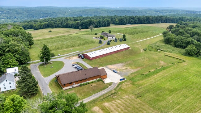

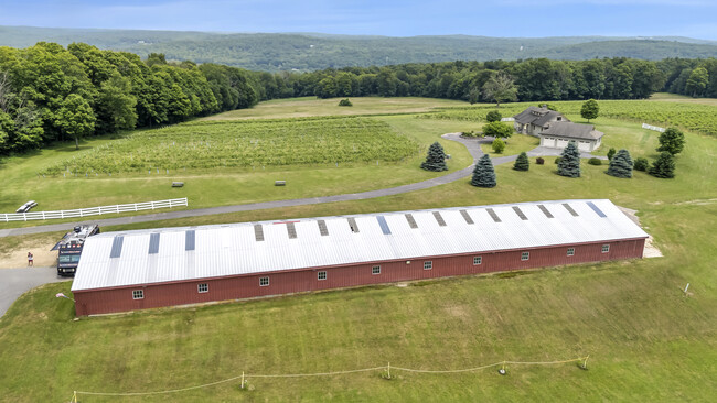
Property Detail
454 Cassidy Hill Rd
Hartford-West Hartford-East Hartford, CT
Capitol
COVE-000001-000028-A000000-000005
Connecticut
Commercialofficeresidentialmixeduse
43
GR80
96.50 AC
2025
Tolland County
2025
Hartford
850100
NEARBY LISTINGS FOR SALE OR LEASE
-
-
View all Coventry listings for sale on LoopNet.com
DEMOGRAPHICS near 454 Cassidy Hill Rd
1 mile
3 mile
5 mile
2025 Total Population
1,003
11,043
41,740
2030 Population
1,017
11,294
42,638
Pop Growth 2025-2030
+ 1.40%
+ 2.27%
+ 2.15%
Average Age
42
40
36
2025 Total Households
388
4,261
12,344
HH Growth 2025-2030
+ 1.55%
+ 2.37%
+ 2.62%
Median Household Inc
$119,021
$100,416
$98,086
Avg Household Size
2.60
2.40
2.40
2025 Avg HH Vehicles
3.00
2.00
2.00
Median Home Value
$359,782
$336,219
$343,658
Median Year Built
1978
1977
1976
Nearby Places
Map Layers
Map Styles
 Street
 Aerial
Layers
 Traffic
 Biking
Places
Listings with unknown addresses are not visible on the map
- Restaurants
- Banks
- Shops
- Fitness
- Groceries
PUBLIC TRANSPORTATION
AIRPORT
Bradley International
Drive
Walk
Distance
Bradley International
57 min
30.9 mi
Freight Ports
Port of New Haven
Drive
Walk
Distance
Port of New Haven
80 min
59.4 mi
SALE & LEASE HISTORY
LISTING DATE
SALE/LEASE

Sep 09, 2024
For Sale
Nearby Properties
Address
Land Use
TOTAL SIZE
Lot Size
Zoning
Address
Land Use
TOTAL SIZE
Lot Size
Zoning
258,330 SF
68.50 AC
RDD
Address
Land Use
TOTAL SIZE
Lot Size
Zoning
168,410 SF
100.15 AC
RDD
Address
Land Use
TOTAL SIZE
Lot Size
Zoning
23.33 AC
PB3
Address
Land Use
TOTAL SIZE
Lot Size
Zoning
20.50 AC
GDD
Address
Land Use
TOTAL SIZE
Lot Size
Zoning
48 AC
RDD
Address
Land Use
TOTAL SIZE
Lot Size
Zoning
75,689 SF
20 AC
R80
Address
Land Use
TOTAL SIZE
Lot Size
Zoning
63,016 SF
8.60 AC
R80
Address
Land Use
TOTAL SIZE
Lot Size
Zoning
113,904 SF
38.80 AC
R80
Address
Land Use
TOTAL SIZE
Lot Size
Zoning
59.01 AC
RDD
Address
Land Use
TOTAL SIZE
Lot Size
Zoning
61,155 SF
34 AC
R80
Address
Land Use
TOTAL SIZE
Lot Size
Zoning
38,376 SF
Address
Land Use
TOTAL SIZE
Lot Size
Zoning
38,103 SF
8.80 AC
RAR90
Address
Land Use
TOTAL SIZE
Lot Size
Zoning
30,480 SF
Address
Land Use
TOTAL SIZE
Lot Size
Zoning
29,696 SF
Address
Land Use
TOTAL SIZE
Lot Size
Zoning
13.47 AC
RAR90
Address
Land Use
TOTAL SIZE
Lot Size
Zoning
35.50 AC
RAR90
Address
Land Use
TOTAL SIZE
Lot Size
Zoning
33,328 SF
17.48 AC
R80
Address
Land Use
TOTAL SIZE
Lot Size
Zoning
1,352 SF
50.51 AC
RAR90
Address
Land Use
TOTAL SIZE
Lot Size
Zoning
50.71 AC
GDD
Address
Land Use
TOTAL SIZE
Lot Size
Zoning
22.55 AC
RAR90
Address
Land Use
TOTAL SIZE
Lot Size
Zoning
1,290 SF
200 AC
Address
Land Use
TOTAL SIZE
Lot Size
Zoning
9.05 AC
TCZ
Address
Land Use
TOTAL SIZE
Lot Size
Zoning
16,414 SF
3.44 AC
GDD
Address
Land Use
TOTAL SIZE
Lot Size
Zoning
10,728 SF
39.68 AC
RDD
Address
Land Use
TOTAL SIZE
Lot Size
Zoning
37,556 SF
7.91 AC
GDD
Address
Land Use
TOTAL SIZE
Lot Size
Zoning
1,200 SF
108 AC
RDD
Address
Land Use
TOTAL SIZE
Lot Size
Zoning
1,132 SF
0.78 AC
RDD
Address
Land Use
TOTAL SIZE
Lot Size
Zoning
12,277 SF
15.64 AC
RAR90
Address
Land Use
TOTAL SIZE
Lot Size
Zoning
3,210 SF
1 AC
RAR90
Address
Land Use
TOTAL SIZE
Lot Size
Zoning
4.70 AC
PB3
The World's #1 Commercial Real Estate Marketplace
Connect with us
© 2026 CoStar Group
The information above has been obtained from sources believed reliable. While we do not doubt its accuracy we have not verified it and make no guarantee, warranty or representation about it. It is your responsibility to independently confirm its accuracy and completeness. Any projections, opinions, assumptions, or estimates used are for example only and do not represent the current or future performance of the property. The value of this transaction to you depends on tax and other factors which should be evaluated by your tax, financial, and legal advisors. You and your advisors should conduct a careful, independent investigation of the property to determine to your satisfaction the suitability of the property for your needs.