Property Record
4545 E Shea Blvd, Phoenix, AZ 85028
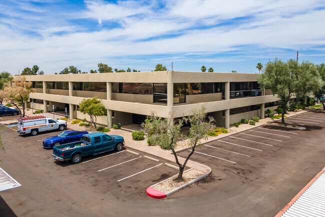

Property Detail
4545 E Shea Blvd
168-09-001L
PT E2 NE4 NW4 NE4 DAF COM NW COR SD E2 TH E 85F TH S 80.01F TO POB TH E 228.15F TH N 88D 54M E 16.36F TO E LN SD E2 TH S ALG SD E LN 393.30F TH W 171.64F TH N 50D 48M W 145.58F TH N 180.21F TH N 28D 54M E 83.15F TH N 54F TO POB
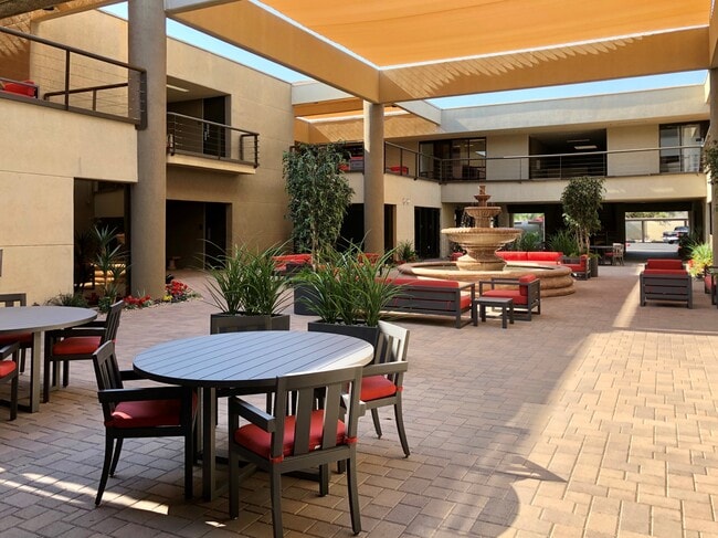
Officebuilding
Maricopa
C-T
Arizona
C and X Area of minimal flood hazard, usually depicted on FIRMs as above the 500-year flood level.
2.42 AC
2025
Paradise Valley
2025
Phoenix
105101
Phoenix-Mesa-Chandler, AZ
43,509 SF
NEARBY LISTINGS FOR SALE OR LEASE
DEMOGRAPHICS near 4545 E Shea Blvd
1 mile
3 mile
5 mile
2025 Total Population
8,013
70,318
221,302
2030 Population
8,358
72,709
230,660
Pop Growth 2025-2030
+ 4.31%
+ 3.40%
+ 4.23%
Average Age
47
44
44
2025 Total Households
3,600
29,087
94,394
HH Growth 2025-2030
+ 4.67%
+ 3.54%
+ 4.45%
Median Household Inc
$108,389
$106,465
$100,565
Avg Household Size
2.20
2.30
2.30
2025 Avg HH Vehicles
2.00
2.00
2.00
Median Home Value
$807,051
$706,753
$697,076
Median Year Built
1984
1979
1983
Nearby Places
Map Layers
Map Styles
 Street
 Aerial
Transit
 Traffic
 Biking
Places
Listings with unknown addresses are not visible on the map
- Restaurants
- Banks
- Shops
- Fitness
- Groceries
PUBLIC TRANSPORTATION
AIRPORT
Phoenix Sky Harbor International
Drive
Walk
Distance
Phoenix Sky Harbor International
24 min
15.1 mi
Phoenix-Mesa Gateway
Drive
Walk
Distance
Phoenix-Mesa Gateway
54 min
38.0 mi
SALE & LEASE HISTORY
LISTING DATE
SALE/LEASE

Oct 07, 2024
For Lease
Feb 16, 2024
For Lease
Nearby Properties
Address
Land Use
TOTAL SIZE
Lot Size
Zoning
Address
Land Use
TOTAL SIZE
Lot Size
Zoning
17.81 AC
Address
Land Use
TOTAL SIZE
Lot Size
Zoning
128,046 SF
9.97 AC
C2
Address
Land Use
TOTAL SIZE
Lot Size
Zoning
33,244 SF
5.93 AC
C-2
Address
Land Use
TOTAL SIZE
Lot Size
Zoning
4.67 AC
Address
Land Use
TOTAL SIZE
Lot Size
Zoning
367,367 SF
37.89 AC
R-43
Address
Land Use
TOTAL SIZE
Lot Size
Zoning
9,232 SF
4.07 AC
R-35
Address
Land Use
TOTAL SIZE
Lot Size
Zoning
580,563 SF
9 AC
C-T
Address
Land Use
TOTAL SIZE
Lot Size
Zoning
512,499 SF
23.03 AC
R3A
Address
Land Use
TOTAL SIZE
Lot Size
Zoning
323,288 SF
40.56 AC
R1-10
Address
Land Use
TOTAL SIZE
Lot Size
Zoning
167,532 SF
30 AC
R-14
Address
Land Use
TOTAL SIZE
Lot Size
Zoning
352,440 SF
17.51 AC
R-5
Address
Land Use
TOTAL SIZE
Lot Size
Zoning
1.26 AC
Address
Land Use
TOTAL SIZE
Lot Size
Zoning
162,334 SF
18.85 AC
R-35
Address
Land Use
TOTAL SIZE
Lot Size
Zoning
415,053 SF
6.29 AC
Address
Land Use
TOTAL SIZE
Lot Size
Zoning
168,217 SF
40 AC
R-14
Address
Land Use
TOTAL SIZE
Lot Size
Zoning
245,623 SF
5.09 AC
I-P
Address
Land Use
TOTAL SIZE
Lot Size
Zoning
281,018 SF
9.26 AC
M-H
Address
Land Use
TOTAL SIZE
Lot Size
Zoning
208,370 SF
19.49 AC
Address
Land Use
TOTAL SIZE
Lot Size
Zoning
135,017 SF
10.42 AC
C-R
Address
Land Use
TOTAL SIZE
Lot Size
Zoning
81,692 SF
8.65 AC
R-10
Address
Land Use
TOTAL SIZE
Lot Size
Zoning
180,205 SF
11.53 AC
C-C
Address
Land Use
TOTAL SIZE
Lot Size
Zoning
110,623 SF
4.39 AC
R-10
Address
Land Use
TOTAL SIZE
Lot Size
Zoning
80,300 SF
19.39 AC
PF
Address
Land Use
TOTAL SIZE
Lot Size
Zoning
1.31 AC
Address
Land Use
TOTAL SIZE
Lot Size
Zoning
0.88 AC
Address
Land Use
TOTAL SIZE
Lot Size
Zoning
81,656 SF
12.27 AC
C-C
Address
Land Use
TOTAL SIZE
Lot Size
Zoning
435,890 SF
16.51 AC
R5
Address
Land Use
TOTAL SIZE
Lot Size
Zoning
153,236 SF
11.35 AC
C-R
Address
Land Use
TOTAL SIZE
Lot Size
Zoning
341,747 SF
17.61 AC
R-2
Address
Land Use
TOTAL SIZE
Lot Size
Zoning
0.86 AC
The World's #1 Commercial Real Estate Marketplace
Connect with us
© 2026 CoStar Group
The information above has been obtained from sources believed reliable. While we do not doubt its accuracy we have not verified it and make no guarantee, warranty or representation about it. It is your responsibility to independently confirm its accuracy and completeness. Any projections, opinions, assumptions, or estimates used are for example only and do not represent the current or future performance of the property. The value of this transaction to you depends on tax and other factors which should be evaluated by your tax, financial, and legal advisors. You and your advisors should conduct a careful, independent investigation of the property to determine to your satisfaction the suitability of the property for your needs.