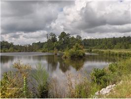
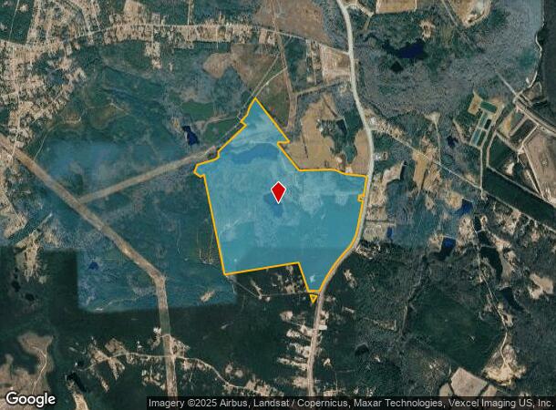
Property Record
4545 Mike Padgett Hwy, Augusta, GA 30906
NEARBY LISTINGS FOR SALE OR LEASE
Property Detail
4545 Mike Padgett Hwy
2560001000
4545 MIKE PADGETT HWY
Charitableorganization
Richmond
A
Georgia
13245C0240G
338.09 AC
2025
South Richmond County
2025
Augusta/Richmond County
010905
Augusta-Richmond County, GA-SC
4,036 SF
DEMOGRAPHICS near 4545 Mike Padgett Hwy
1 Mile
3 Mile
5 Mile
2024 Total Population
270
4,031
14,233
2029 Population
272
4,036
14,257
Pop Growth 2024-2029
+ 0.74%
+ 0.12%
+ 0.17%
Average Age
40
40
39
2024 Total Households
101
1,545
5,376
HH Growth 2024-2029
+ 0.99%
+ 0.19%
+ 0.24%
Median Household Inc
$49,374
$48,613
$54,308
Avg Household Size
2.50
2.60
2.60
2024 Avg HH Vehicles
2.00
2.00
2.00
Median Home Value
$147,435
$146,634
$142,669
Median Year Built
1984
1983
1988
Nearby Places
Map Layers
Map Styles
 Street
 Aerial
- Restaurants
- Banks
- Shops
- Fitness
- Groceries
PUBLIC TRANSPORTATION
AIRPORT
Augusta Regional at Bush Field
DRIVE
WALK
Distance
Augusta Regional at Bush Field
17 min
8.4 mi
Freight Ports
Georgia Ports - Savannah
DRIVE
WALK
Distance
Georgia Ports - Savannah
134 min
103.8 mi
Nearby Properties
Address
Land Use
TOTAL SIZE
Lot Size
Zoning
Address
Land Use
TOTAL SIZE
Lot Size
Zoning
130,831 SF
100 AC
HI
Address
Land Use
TOTAL SIZE
Lot Size
Zoning
16,664 SF
240.88 AC
HI_B-1_A
Address
Land Use
TOTAL SIZE
Lot Size
Zoning
150.01 AC
Address
Land Use
TOTAL SIZE
Lot Size
Zoning
130,831 SF
100 AC
HI
Address
Land Use
TOTAL SIZE
Lot Size
Zoning
23,184 SF
6.88 AC
R-3C
Address
Land Use
TOTAL SIZE
Lot Size
Zoning
720 SF
37.27 AC
HI
Address
Land Use
TOTAL SIZE
Lot Size
Zoning
12,430 SF
58.24 AC
HI
Address
Land Use
TOTAL SIZE
Lot Size
Zoning
1,640 SF
623.61 AC
HI
Address
Land Use
TOTAL SIZE
Lot Size
Zoning
2,744 SF
177.83 AC
A_HI
Address
Land Use
TOTAL SIZE
Lot Size
Zoning
13,565 SF
151.34 AC
HI
Address
Land Use
TOTAL SIZE
Lot Size
Zoning
13,435 SF
270.98 AC
HI
Address
Land Use
TOTAL SIZE
Lot Size
Zoning
323.80 AC
HI
Address
Land Use
TOTAL SIZE
Lot Size
Zoning
29,620 SF
3.85 AC
HI
Address
Land Use
TOTAL SIZE
Lot Size
Zoning
12,665 SF
210.38 AC
A,B
Address
Land Use
TOTAL SIZE
Lot Size
Zoning
34,001 SF
9.33 AC
LI
Address
Land Use
TOTAL SIZE
Lot Size
Zoning
7,200 SF
3.33 AC
HI
Address
Land Use
TOTAL SIZE
Lot Size
Zoning
10,508 SF
2.78 AC
A
Address
Land Use
TOTAL SIZE
Lot Size
Zoning
2,098 SF
23.14 AC
A_HI
Address
Land Use
TOTAL SIZE
Lot Size
Zoning
4,584 SF
5.57 AC
003
Address
Land Use
TOTAL SIZE
Lot Size
Zoning
9,000 SF
10.53 AC
HI
Address
Land Use
TOTAL SIZE
Lot Size
Zoning
1,280 SF
23.95 AC
HI
Address
Land Use
TOTAL SIZE
Lot Size
Zoning
71,913 SF
19.29 AC
HI
Address
Land Use
TOTAL SIZE
Lot Size
Zoning
248.57 AC
R-1B
Address
Land Use
TOTAL SIZE
Lot Size
Zoning
2,080 SF
7.98 AC
HI
Address
Land Use
TOTAL SIZE
Lot Size
Zoning
9,400 SF
9.69 AC
HI
Address
Land Use
TOTAL SIZE
Lot Size
Zoning
3,361 SF
203.29 AC
HI
Address
Land Use
TOTAL SIZE
Lot Size
Zoning
3,000 SF
16.25 AC
A_B-2
Address
Land Use
TOTAL SIZE
Lot Size
Zoning
11,315 SF
3.40 AC
R-1
Address
Land Use
TOTAL SIZE
Lot Size
Zoning
4,800 SF
8.88 AC
LI
Address
Land Use
TOTAL SIZE
Lot Size
Zoning
7,500 SF
2.55 AC
A,B
The World's #1 Commercial Real Estate Marketplace
Connect with us
© 2026 CoStar Group
The information above has been obtained from sources believed reliable. While we do not doubt its accuracy we have not verified it and make no guarantee, warranty or representation about it. It is your responsibility to independently confirm its accuracy and completeness. Any projections, opinions, assumptions, or estimates used are for example only and do not represent the current or future performance of the property. The value of this transaction to you depends on tax and other factors which should be evaluated by your tax, financial, and legal advisors. You and your advisors should conduct a careful, independent investigation of the property to determine to your satisfaction the suitability of the property for your needs.