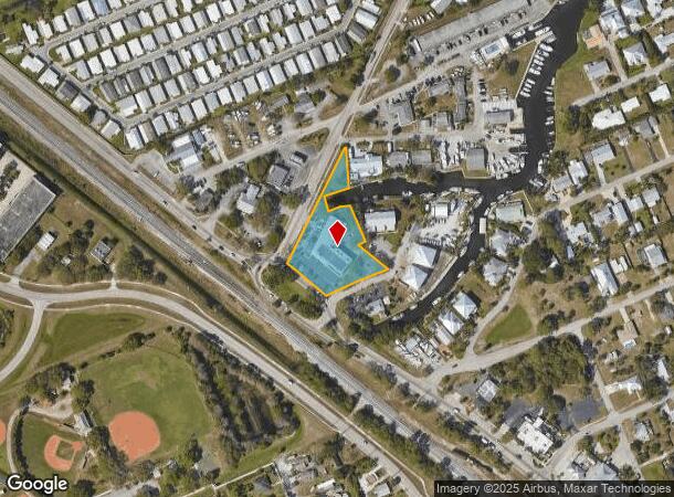
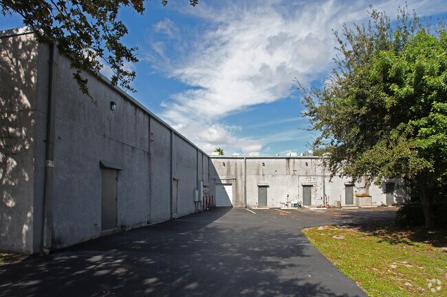
Property Record
4545 Se Dixie Hwy, Stuart, FL 34997

NEARBY LISTINGS FOR SALE OR LEASE
Property Detail
4545 Se Dixie Hwy
Port St Lucie, FL
Kiedingers Unrecorded
52-38-41-008-000-00180-9
KIEDINGERS UNREC LOTS 18 & 45 & MANATEE BAY REV PLAT LOTS 22 & 23 (LESS R/W FROM LOT 18) MANATEE PLAZA
Regionalshoppingcenterormallwithanchorstore
Martin
AE
Florida
12085C0164H
18 &
2024
1.29 AC
2025
Martin
001301
Port St Lucie/Fort Pierce
10,711 SF
DEMOGRAPHICS near 4545 Se Dixie Hwy
1 Mile
3 Mile
5 Mile
2024 Total Population
5,898
43,388
82,317
2029 Population
6,280
45,766
87,106
Pop Growth 2024-2029
+ 6.48%
+ 5.48%
+ 5.82%
Average Age
48
48
50
2024 Total Households
2,555
18,981
37,354
HH Growth 2024-2029
+ 6.22%
+ 5.65%
+ 6.00%
Median Household Inc
$59,279
$60,342
$62,017
Avg Household Size
2.20
2.20
2.10
2024 Avg HH Vehicles
2.00
2.00
2.00
Median Home Value
$296,097
$288,913
$308,437
Median Year Built
1980
1985
1985
Nearby Places
Map Layers
Map Styles
 Street
 Aerial
- Restaurants
- Banks
- Shops
- Fitness
- Groceries
PUBLIC TRANSPORTATION
AIRPORT
Palm Beach International
DRIVE
WALK
Distance
Palm Beach International
56 min
42.2 mi
Nearby Properties
Address
Land Use
TOTAL SIZE
Lot Size
Zoning
Address
Land Use
TOTAL SIZE
Lot Size
Zoning
436,532 SF
636.83 AC
PAF
Address
Land Use
TOTAL SIZE
Lot Size
Zoning
309,276 SF
13.73 AC
CPUD
Address
Land Use
TOTAL SIZE
Lot Size
Zoning
232,042 SF
30.99 AC
PUDR
Address
Land Use
TOTAL SIZE
Lot Size
Zoning
13.62 AC
R2
Address
Land Use
TOTAL SIZE
Lot Size
Zoning
118,989 SF
12.43 AC
PUDC
Address
Land Use
TOTAL SIZE
Lot Size
Zoning
15.79 AC
Address
Land Use
TOTAL SIZE
Lot Size
Zoning
310,460 SF
48.85 AC
PS2
Address
Land Use
TOTAL SIZE
Lot Size
Zoning
200,686 SF
9.98 AC
RPUD
Address
Land Use
TOTAL SIZE
Lot Size
Zoning
284,610 SF
33.04 AC
R3
Address
Land Use
TOTAL SIZE
Lot Size
Zoning
195,729 SF
20.25 AC
CPUD
Address
Land Use
TOTAL SIZE
Lot Size
Zoning
545,151 SF
62.49 AC
PAF
Address
Land Use
TOTAL SIZE
Lot Size
Zoning
85,872 SF
7.91 AC
CPUD
Address
Land Use
TOTAL SIZE
Lot Size
Zoning
126,304 SF
36 AC
R2
Address
Land Use
TOTAL SIZE
Lot Size
Zoning
334,117 SF
54 AC
RPUD
Address
Land Use
TOTAL SIZE
Lot Size
Zoning
307,010 SF
33.70 AC
CPUD
Address
Land Use
TOTAL SIZE
Lot Size
Zoning
45,029 SF
11.80 AC
PUDC
Address
Land Use
TOTAL SIZE
Lot Size
Zoning
136,749 SF
14.90 AC
GC
Address
Land Use
TOTAL SIZE
Lot Size
Zoning
212,454 SF
33.77 AC
CPUD
Address
Land Use
TOTAL SIZE
Lot Size
Zoning
171,655 SF
15.17 AC
B2
Address
Land Use
TOTAL SIZE
Lot Size
Zoning
136,615 SF
21.72 AC
Address
Land Use
TOTAL SIZE
Lot Size
Zoning
48,450 SF
7.94 AC
Address
Land Use
TOTAL SIZE
Lot Size
Zoning
30,423 SF
13.74 AC
WGC
Address
Land Use
TOTAL SIZE
Lot Size
Zoning
59,023 SF
12.31 AC
Address
Land Use
TOTAL SIZE
Lot Size
Zoning
106,105 SF
7.41 AC
PUDR
Address
Land Use
TOTAL SIZE
Lot Size
Zoning
102,843 SF
9.03 AC
Address
Land Use
TOTAL SIZE
Lot Size
Zoning
153,260 SF
13.50 AC
PS
Address
Land Use
TOTAL SIZE
Lot Size
Zoning
105,716 SF
10.13 AC
R5
Address
Land Use
TOTAL SIZE
Lot Size
Zoning
192,772 SF
18.80 AC
M1
Address
Land Use
TOTAL SIZE
Lot Size
Zoning
50,773 SF
9.40 AC
COR2
Address
Land Use
TOTAL SIZE
Lot Size
Zoning
100,318 SF
14.98 AC
CPUD
The World's #1 Commercial Real Estate Marketplace
Connect with us
© 2025 CoStar Group
The information above has been obtained from sources believed reliable. While we do not doubt its accuracy we have not verified it and make no guarantee, warranty or representation about it. It is your responsibility to independently confirm its accuracy and completeness. Any projections, opinions, assumptions, or estimates used are for example only and do not represent the current or future performance of the property. The value of this transaction to you depends on tax and other factors which should be evaluated by your tax, financial, and legal advisors. You and your advisors should conduct a careful, independent investigation of the property to determine to your satisfaction the suitability of the property for your needs.