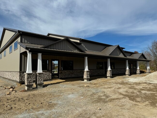
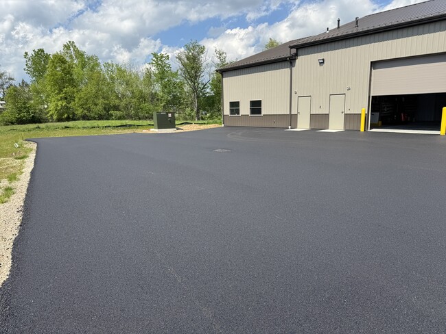
Property Record
4547 Mogadore Rd, Kent, OH 44240
Current Lease Availabilities
NEARBY LISTINGS FOR SALE OR LEASE
-
-
View all Kent listings for lease on LoopNet.com
Property Detail
4547 Mogadore Rd
04-020-00-00-022-000
LOT 20
Recreationalacreage
Portage
X
Ohio
39153C0210F
20
2024
4.10 AC
2024
Portage County
601703
Cleveland
1,090 SF
Akron, OH
DEMOGRAPHICS near 4547 Mogadore Rd
1 Mile
3 Mile
5 Mile
2024 Total Population
1,371
29,602
107,886
2029 Population
1,418
29,827
107,764
Pop Growth 2024-2029
+ 3.43%
+ 0.76%
(0.11%)
Average Age
39
40
40
2024 Total Households
645
12,928
45,207
HH Growth 2024-2029
+ 3.26%
+ 0.68%
(0.10%)
Median Household Inc
$62,039
$64,434
$63,644
Avg Household Size
2.10
2.20
2.20
2024 Avg HH Vehicles
2.00
2.00
2.00
Median Home Value
$219,032
$205,051
$182,278
Median Year Built
2001
1972
1970
Nearby Places
- Restaurants
- Banks
- Shops
- Fitness
- Groceries
PUBLIC TRANSPORTATION
AIRPORT
Akron-Canton Regional
DRIVE
WALK
Distance
Akron-Canton Regional
27 min
20.7 mi
Freight Ports
Port of Toledo
DRIVE
WALK
Distance
Port of Toledo
166 min
137.6 mi
Nearby Properties
Address
Land Use
TOTAL SIZE
Lot Size
Zoning
Address
Land Use
TOTAL SIZE
Lot Size
Zoning
194,492 SF
37.82 AC
Address
Land Use
TOTAL SIZE
Lot Size
Zoning
183,977 SF
10.12 AC
Address
Land Use
TOTAL SIZE
Lot Size
Zoning
77,663 SF
83.47 AC
Address
Land Use
TOTAL SIZE
Lot Size
Zoning
815,100 SF
66.78 AC
Address
Land Use
TOTAL SIZE
Lot Size
Zoning
176,533 SF
62.50 AC
Address
Land Use
TOTAL SIZE
Lot Size
Zoning
141,562 SF
1.63 AC
Address
Land Use
TOTAL SIZE
Lot Size
Zoning
68,754 SF
25.80 AC
Address
Land Use
TOTAL SIZE
Lot Size
Zoning
179,055 SF
19.68 AC
Address
Land Use
TOTAL SIZE
Lot Size
Zoning
Address
Land Use
TOTAL SIZE
Lot Size
Zoning
193,894 SF
24.63 AC
Address
Land Use
TOTAL SIZE
Lot Size
Zoning
48,734 SF
18.12 AC
Address
Land Use
TOTAL SIZE
Lot Size
Zoning
216,994 SF
10.94 AC
Address
Land Use
TOTAL SIZE
Lot Size
Zoning
161,806 SF
1.92 AC
Address
Land Use
TOTAL SIZE
Lot Size
Zoning
52,575 SF
1.33 AC
Address
Land Use
TOTAL SIZE
Lot Size
Zoning
91,286 SF
27.27 AC
Address
Land Use
TOTAL SIZE
Lot Size
Zoning
34,394 SF
3.59 AC
Address
Land Use
TOTAL SIZE
Lot Size
Zoning
212,628 SF
27.25 AC
Address
Land Use
TOTAL SIZE
Lot Size
Zoning
176,320 SF
1.73 AC
Address
Land Use
TOTAL SIZE
Lot Size
Zoning
33,561 SF
2.62 AC
Address
Land Use
TOTAL SIZE
Lot Size
Zoning
67,107 SF
9.29 AC
Address
Land Use
TOTAL SIZE
Lot Size
Zoning
63,288 SF
0.88 AC
Address
Land Use
TOTAL SIZE
Lot Size
Zoning
88,682 SF
11.55 AC
Address
Land Use
TOTAL SIZE
Lot Size
Zoning
73,306 SF
0.78 AC
Address
Land Use
TOTAL SIZE
Lot Size
Zoning
68,649 SF
13.45 AC
Address
Land Use
TOTAL SIZE
Lot Size
Zoning
78,805 SF
9.13 AC
Address
Land Use
TOTAL SIZE
Lot Size
Zoning
250,693 SF
93.26 AC
Address
Land Use
TOTAL SIZE
Lot Size
Zoning
130,766 SF
16.45 AC
Address
Land Use
TOTAL SIZE
Lot Size
Zoning
Address
Land Use
TOTAL SIZE
Lot Size
Zoning
62,390 SF
8.39 AC
Address
Land Use
TOTAL SIZE
Lot Size
Zoning
57,542 SF
9.44 AC
The World's #1 Commercial Real Estate Marketplace
Connect with us
© 2025 CoStar Group
The information above has been obtained from sources believed reliable. While we do not doubt its accuracy we have not verified it and make no guarantee, warranty or representation about it. It is your responsibility to independently confirm its accuracy and completeness. Any projections, opinions, assumptions, or estimates used are for example only and do not represent the current or future performance of the property. The value of this transaction to you depends on tax and other factors which should be evaluated by your tax, financial, and legal advisors. You and your advisors should conduct a careful, independent investigation of the property to determine to your satisfaction the suitability of the property for your needs.