Property Record
4549 State Route 9, Plattsburgh, NY 12901
NEARBY LISTINGS FOR SALE OR LEASE
-
-
View all Plattsburgh listings for sale on LoopNet.com
Property Detail
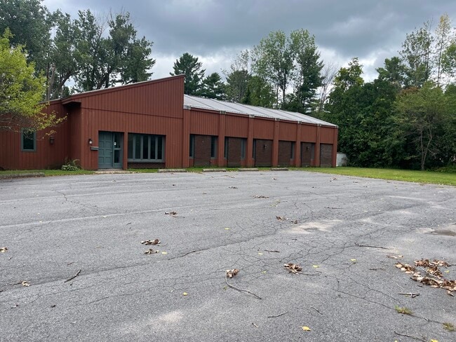
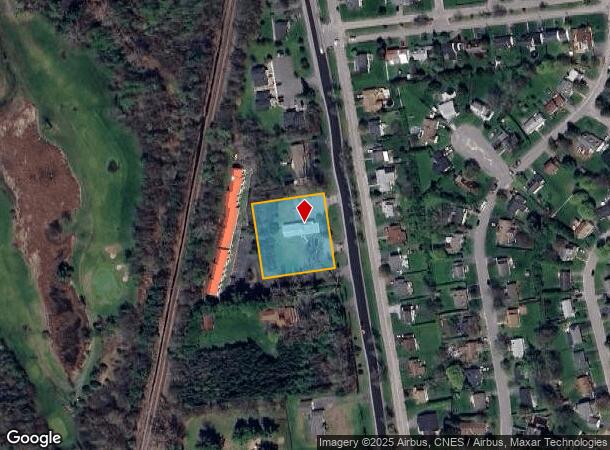
4549 State Route 9
094200-233-016-0005-004-000-0000
PAT POP
Officebuilding
Clinton
X
New York
36019C0612E
4.000
2025
0.96 AC
2024
Adirondack Mountains Area
102100
Other Market Areas
3,131 SF
Plattsburgh, NY
DEMOGRAPHICS near 4549 State Route 9
1 mile
3 mile
5 mile
2024 Total Population
1,229
14,467
27,365
2029 Population
1,237
14,443
27,307
Pop Growth 2024-2029
+ 0.65%
(0.17%)
(0.21%)
Average Age
46
41
42
2024 Total Households
577
7,011
12,798
HH Growth 2024-2029
+ 0.52%
(0.19%)
(0.22%)
Median Household Inc
$80,958
$48,958
$54,550
Avg Household Size
2.10
2.00
2.10
2024 Avg HH Vehicles
2.00
1.00
1.00
Median Home Value
$167,712
$147,416
$155,051
Median Year Built
1975
1966
1970
Nearby Places
Map Layers
Map Styles
 Street
 Aerial
Transit
 Traffic
 Biking
Places
Listings with unknown addresses are not visible on the map
- Restaurants
- Banks
- Shops
- Fitness
- Groceries
PUBLIC TRANSPORTATION
COMMUTER RAIL
Plattsburgh Amtrak Station (Adirondack - Amtrak)
Drive
Walk
Distance
Plattsburgh Amtrak Station (Adirondack - Amtrak)
5 min
3.0 mi
AIRPORT
Plattsburgh International
Drive
Walk
Distance
Plattsburgh International
4 min
1.7 mi
Patrick Leahy Burlington International
Drive
Walk
Distance
Patrick Leahy Burlington International
71 min
33.8 mi
Freight Ports
Montreal
Drive
Walk
Distance
Montreal
90 min
68.2 mi
Nearby Properties
Address
Land Use
TOTAL SIZE
Lot Size
Zoning
Address
Land Use
TOTAL SIZE
Lot Size
Zoning
103.84 AC
Address
Land Use
TOTAL SIZE
Lot Size
Zoning
800 SF
776.23 AC
A1
Address
Land Use
TOTAL SIZE
Lot Size
Zoning
3,545 SF
17.30 AC
06 - INDUS
Address
Land Use
TOTAL SIZE
Lot Size
Zoning
15.80 AC
Address
Land Use
TOTAL SIZE
Lot Size
Zoning
121,465 SF
92 AC
R-2
Address
Land Use
TOTAL SIZE
Lot Size
Zoning
564.20 AC
A1
Address
Land Use
TOTAL SIZE
Lot Size
Zoning
35,562 SF
204.40 AC
LC_OS
Address
Land Use
TOTAL SIZE
Lot Size
Zoning
167 AC
02 - SINGL
Address
Land Use
TOTAL SIZE
Lot Size
Zoning
117,847 SF
47.30 AC
00
Address
Land Use
TOTAL SIZE
Lot Size
Zoning
148,340 SF
5.67 AC
03 - MULTI
Address
Land Use
TOTAL SIZE
Lot Size
Zoning
243,951 SF
21 AC
06 - INDUS
Address
Land Use
TOTAL SIZE
Lot Size
Zoning
218,230 SF
38.92 AC
I
Address
Land Use
TOTAL SIZE
Lot Size
Zoning
4,992 SF
13.20 AC
03 - MULTI
Address
Land Use
TOTAL SIZE
Lot Size
Zoning
11,910 SF
3.70 AC
05 - COMME
Address
Land Use
TOTAL SIZE
Lot Size
Zoning
84,193 SF
10.60 AC
03 - MULTI
Address
Land Use
TOTAL SIZE
Lot Size
Zoning
59,670 SF
0.50 AC
03 - MULTI
Address
Land Use
TOTAL SIZE
Lot Size
Zoning
210,800 SF
2.42 AC
I
Address
Land Use
TOTAL SIZE
Lot Size
Zoning
229,741 SF
10.90 AC
06 - INDUS
Address
Land Use
TOTAL SIZE
Lot Size
Zoning
21,396 SF
3.40 AC
03 - MULTI
Address
Land Use
TOTAL SIZE
Lot Size
Zoning
52,236 SF
9.14 AC
07 - MIXED
Address
Land Use
TOTAL SIZE
Lot Size
Zoning
131,093 SF
5.84 AC
I
Address
Land Use
TOTAL SIZE
Lot Size
Zoning
73,724 SF
17.30 AC
05 - COMME
Address
Land Use
TOTAL SIZE
Lot Size
Zoning
88,785 SF
3.64 AC
07 - MIXED
Address
Land Use
TOTAL SIZE
Lot Size
Zoning
44,452 SF
1.90 AC
11
Address
Land Use
TOTAL SIZE
Lot Size
Zoning
76,900 SF
6.90 AC
03 - MULTI
Address
Land Use
TOTAL SIZE
Lot Size
Zoning
45,887 SF
7.66 AC
07 - MIXED
Address
Land Use
TOTAL SIZE
Lot Size
Zoning
22,080 SF
5.53 AC
A1
Address
Land Use
TOTAL SIZE
Lot Size
Zoning
Address
Land Use
TOTAL SIZE
Lot Size
Zoning
68,264 SF
2.64 AC
03 - MULTI
Address
Land Use
TOTAL SIZE
Lot Size
Zoning
The World's #1 Commercial Real Estate Marketplace
Connect with us
© 2026 CoStar Group
The information above has been obtained from sources believed reliable. While we do not doubt its accuracy we have not verified it and make no guarantee, warranty or representation about it. It is your responsibility to independently confirm its accuracy and completeness. Any projections, opinions, assumptions, or estimates used are for example only and do not represent the current or future performance of the property. The value of this transaction to you depends on tax and other factors which should be evaluated by your tax, financial, and legal advisors. You and your advisors should conduct a careful, independent investigation of the property to determine to your satisfaction the suitability of the property for your needs.