Property Record
4549 Sw Cargo Way, Palm City, FL 34990


NEARBY LISTINGS FOR SALE OR LEASE
Property Detail
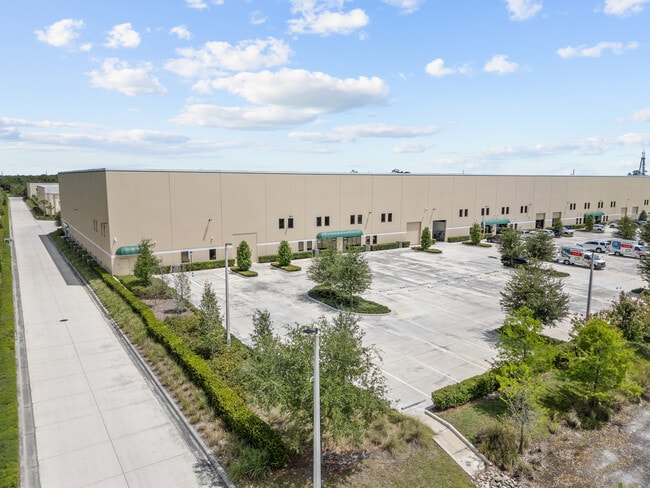
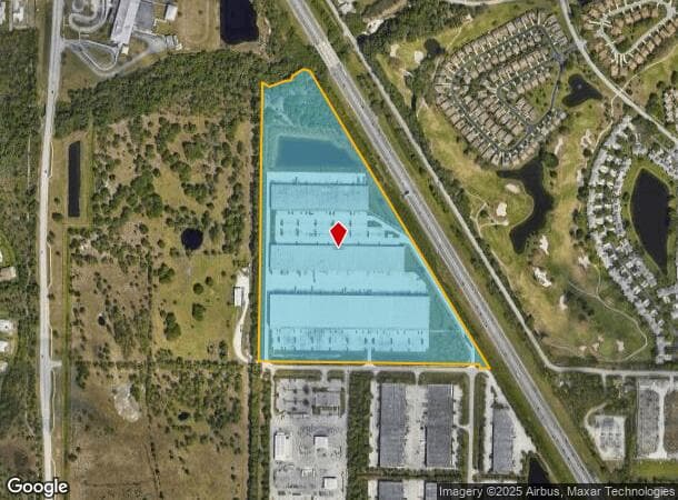
4549 Sw Cargo Way
14-38-40-000-011-00000-0
Palm City Farms
Warehouse
THAT PART OF TRACT 11 LYING SOUTH OF BESSEY CREEK AND WEST OF THE FLORIDA TURNPIKE AND THAT PART OF TRACTS 21 22 27 28 & 29 LYING WEST OF THE FLORIDA TURNPIKE AND ALL OF TRACT 27 ALL IN SEC 14-38-40 PALM CITY FARMS SUBDIVISION ACCORDING TO THE PLAT T
AE
Martin
12085C0140H
Florida
2024
35.81 AC
2025
St Lucie Inland
001701
Port St Lucie/Fort Pierce
217,500 SF
Port St. Lucie, FL
DEMOGRAPHICS near 4549 Sw Cargo Way
1 Mile
3 Mile
5 Mile
2024 Total Population
2,877
23,906
69,777
2029 Population
3,013
25,147
76,360
Pop Growth 2024-2029
+ 4.73%
+ 5.19%
+ 9.43%
Average Age
46
47
46
2024 Total Households
1,182
9,767
28,333
HH Growth 2024-2029
+ 4.48%
+ 5.27%
+ 9.01%
Median Household Inc
$80,606
$95,288
$78,599
Avg Household Size
2.30
2.40
2.30
2024 Avg HH Vehicles
2.00
2.00
2.00
Median Home Value
$359,146
$444,163
$361,102
Median Year Built
1987
1992
1992
Nearby Places
Map Layers
Map Styles
 Street
 Aerial
- Restaurants
- Banks
- Shops
- Fitness
- Groceries
SALE & LEASE HISTORY
LISTING DATE
SALE/LEASE

Oct 01, 2019
For Lease
Nov 04, 2024
For Lease
Jun 21, 2024
For Lease
Jun 19, 2024
For Lease
Feb 20, 2025
For Lease
Feb 19, 2025
For Lease
Feb 05, 2020
For Lease
Dec 13, 2022
For Lease
Nearby Properties
Address
Land Use
TOTAL SIZE
Lot Size
Zoning
Address
Land Use
TOTAL SIZE
Lot Size
Zoning
278,311 SF
31.01 AC
PUDR
Address
Land Use
TOTAL SIZE
Lot Size
Zoning
378,814 SF
34.25 AC
PUDR
Address
Land Use
TOTAL SIZE
Lot Size
Zoning
91,310 SF
19.95 AC
PUD
Address
Land Use
TOTAL SIZE
Lot Size
Zoning
517,312 SF
36.82 AC
LI
Address
Land Use
TOTAL SIZE
Lot Size
Zoning
396,105 SF
23.30 AC
M2
Address
Land Use
TOTAL SIZE
Lot Size
Zoning
101,972 SF
15.74 AC
GU
Address
Land Use
TOTAL SIZE
Lot Size
Zoning
78,294 SF
18 AC
PUDR
Address
Land Use
TOTAL SIZE
Lot Size
Zoning
121,646 SF
16.50 AC
PUD
Address
Land Use
TOTAL SIZE
Lot Size
Zoning
52,554 SF
130.53 AC
PUD
Address
Land Use
TOTAL SIZE
Lot Size
Zoning
14,250 SF
40 AC
PS2
Address
Land Use
TOTAL SIZE
Lot Size
Zoning
37,448 SF
2.49 AC
Address
Land Use
TOTAL SIZE
Lot Size
Zoning
101,830 SF
3.12 AC
PUDR
Address
Land Use
TOTAL SIZE
Lot Size
Zoning
1,168 SF
2.37 AC
B2
Address
Land Use
TOTAL SIZE
Lot Size
Zoning
171,741 SF
23.63 AC
PUDR
Address
Land Use
TOTAL SIZE
Lot Size
Zoning
71,848 SF
4.02 AC
PUDR
Address
Land Use
TOTAL SIZE
Lot Size
Zoning
5,269 SF
15.50 AC
R1A
Address
Land Use
TOTAL SIZE
Lot Size
Zoning
51,491 SF
8.47 AC
PUDR
Address
Land Use
TOTAL SIZE
Lot Size
Zoning
56,308 SF
7.60 AC
PUDR
Address
Land Use
TOTAL SIZE
Lot Size
Zoning
17,815 SF
4.57 AC
M2
Address
Land Use
TOTAL SIZE
Lot Size
Zoning
49,599 SF
13.97 AC
CC
Address
Land Use
TOTAL SIZE
Lot Size
Zoning
49,539 SF
6.44 AC
PUDR
Address
Land Use
TOTAL SIZE
Lot Size
Zoning
25,869 SF
5.36 AC
PUDR
Address
Land Use
TOTAL SIZE
Lot Size
Zoning
112,441 SF
15 AC
M2
Address
Land Use
TOTAL SIZE
Lot Size
Zoning
42,281 SF
15.11 AC
A2
Address
Land Use
TOTAL SIZE
Lot Size
Zoning
68,209 SF
6.81 AC
PUDR
Address
Land Use
TOTAL SIZE
Lot Size
Zoning
78,720 SF
17.14 AC
PUDR
Address
Land Use
TOTAL SIZE
Lot Size
Zoning
77,387 SF
9.15 AC
PUDC
Address
Land Use
TOTAL SIZE
Lot Size
Zoning
94.46 AC
Address
Land Use
TOTAL SIZE
Lot Size
Zoning
80,970 SF
14.78 AC
M2
The World's #1 Commercial Real Estate Marketplace
Connect with us
© 2026 CoStar Group
The information above has been obtained from sources believed reliable. While we do not doubt its accuracy we have not verified it and make no guarantee, warranty or representation about it. It is your responsibility to independently confirm its accuracy and completeness. Any projections, opinions, assumptions, or estimates used are for example only and do not represent the current or future performance of the property. The value of this transaction to you depends on tax and other factors which should be evaluated by your tax, financial, and legal advisors. You and your advisors should conduct a careful, independent investigation of the property to determine to your satisfaction the suitability of the property for your needs.